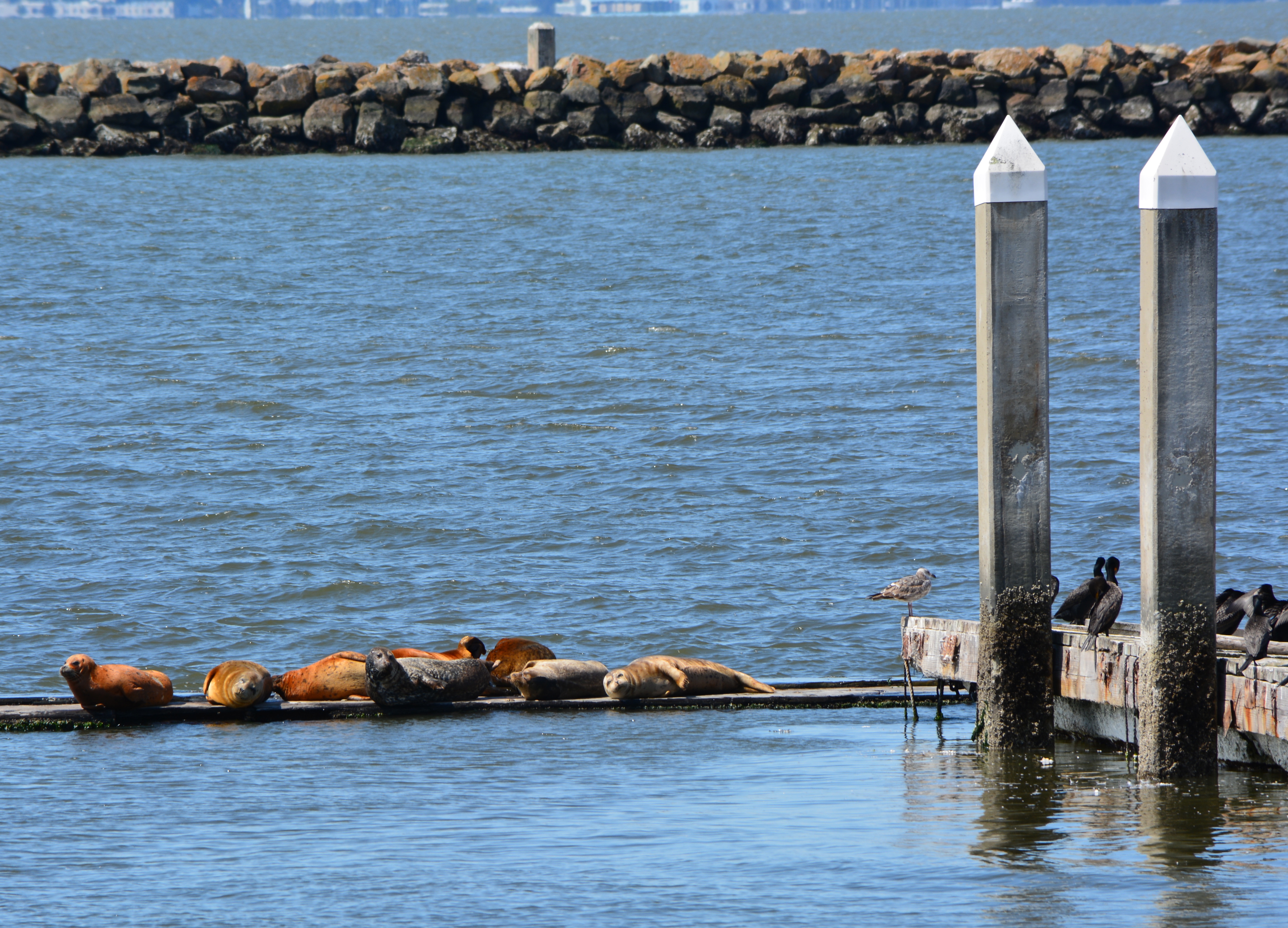
Alameda Point harbor seal float inspires research at New York Aquarium
The harbor seal float at Alameda Point has been wildly successful. It started out as an experiment. Now it’s a model being studied at the New York Aquarium.
In July 2022, the Wildlife Conservation Society’s New York Aquarium installed a float in an exhibit modeled after the float at Alameda Point. The research project was initiated by aquarium keeper Payden Sra as part of her work toward a graduate degree. Studying haul-out behavior of harbor seals in a controlled setting “can better advise conservation actions for the growing wild seal populations managed by local officials on the East Coast,” Sra wrote in the description of her study. “While once a rare sight, it is increasingly common to see seals in New York.”
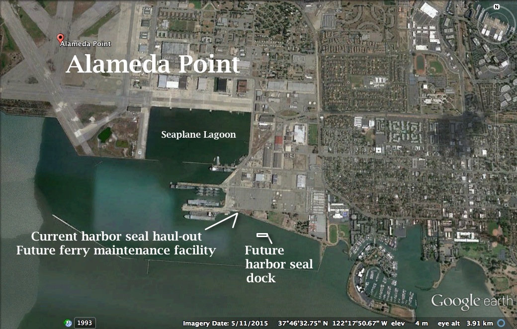
The Water Emergency Transportation Authority (WETA) is aiming for the delivery of a new dock for harbor seals at Alameda Point as early as April, ahead of the start of construction of its new ferry maintenance facility this summer.
Because the maintenance facility’s new berthing dock would displace the seals’ current resting spot, a provision was approved for a new harbor seal dock as a condition for permitting the new facility. WETA, the city council, and the Bay Conservation and Development Commission (BCDC) approved the provision at the urging of community activists.
WETA issued design specifications for its 12-berth maintenance facility and administrative offices to prospective contractors in December. It expects to award the contract on March 31, with work commencing as soon as May 6. The estimated cost is pegged at $45 million, $9 million of which is for design work and the remaining $36 million going for construction, according to Chad Mason, senior planner at WETA. Funding for the project is coming from federal, state, and regional funds.
The facility will include a 70-foot-tall four-story building and is expected to be complete in 2018.
The project will also fund other benefits, among them, a new water line from Main Street, park enhancements, and sand for the least tern nesting area on the airfield.
WETA will construct a shoreline viewing terrace, bicycle parking, interpretive signage, improved lighting and landscaping, and seating on an adjacent half-acre of parkland on West Hornet Avenue.
WETA will also be providing some assistance for the California least terns, an endangered bird species that nests at Alameda Point and dives for fish in surrounding waters. As a mitigation for the impacts of the new ferry traffic on the terns’ foraging waters, WETA will be delivering enough truckloads of sand to the terns’ nesting area on the airfield in February to add a few inches of depth. Erosion of the 9.6-acre beach-like nesting landscape necessitates periodic replenishment.
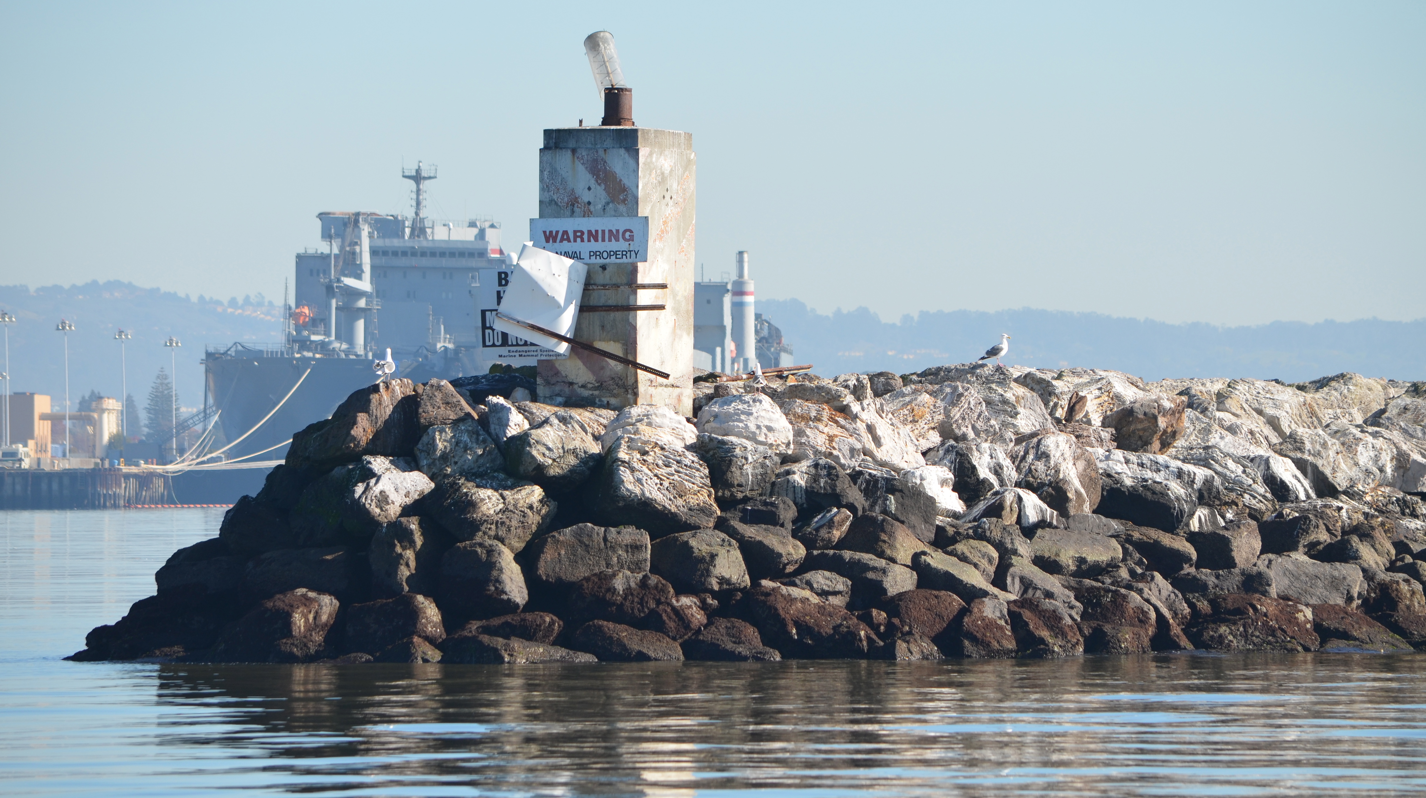
The replacement harbor seal dock, also referred to as a haul-out, will be the first time such a structure has been built on San Francisco Bay specifically to retain or attract harbor seals. It will be located a short distance to the east of the old dock. Time will tell whether this experimental effort is successful.
“Meeting the permitting requirements for the new harbor seal haul-out is underway,” said Mason. BCDC is the state permitting agency for all Bay shoreline and in-water projects. It requires assurances from other agencies that the harbor seal dock does not introduce any unwanted environmental impacts before granting approval.
“With the help of the environmental consulting firm Dudek, the harbor seal haul-out is on a fast-track approval timeline,” said Mason. “The only regulatory delay is due to the herring spawning season. Regulations require that the pilings for the new haul-out be installed after the end of the herring spawning season in late March of 2016.”
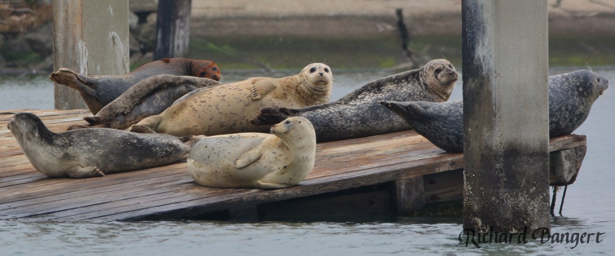
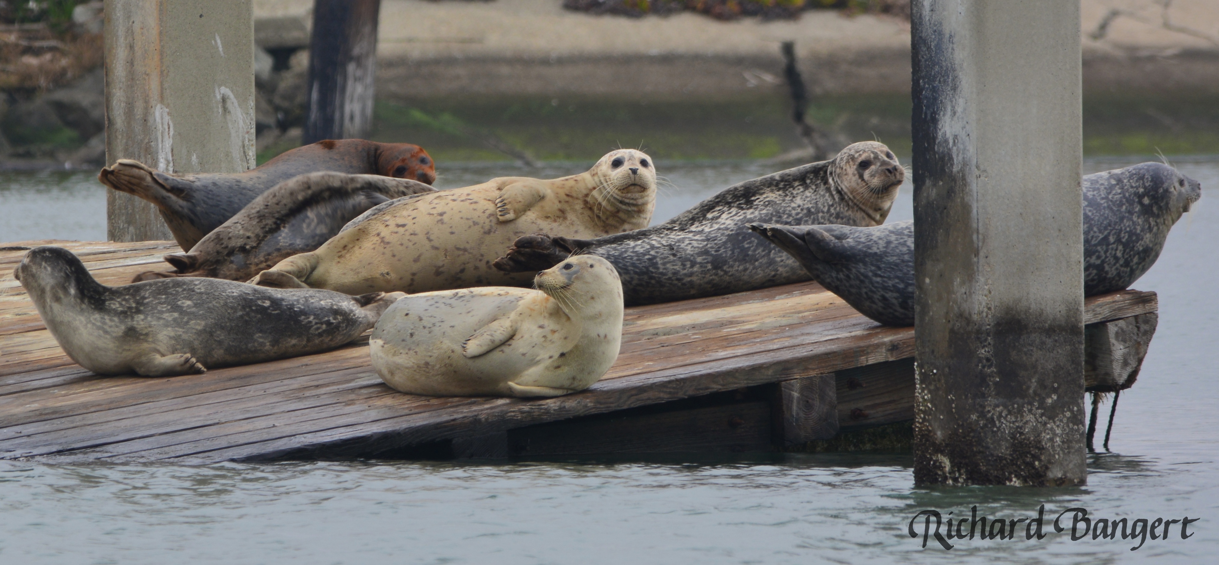
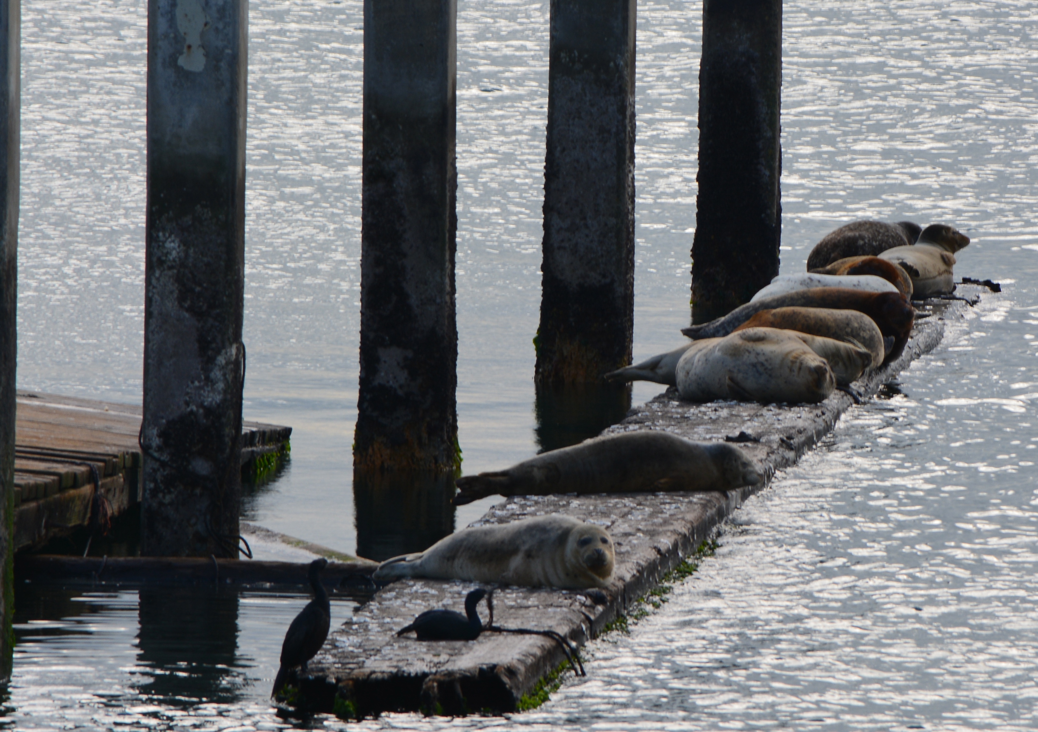
Harbor seals near the old dock in December 2015.
“We are currently reviewing two options for providing the new harbor seal haul-out: Build a new one from scratch, or modify an existing mobile dock if we can find one that meets our needs,” said Mason. “We hope to issue the contract for the haul-out in January.” WETA will be responsible for constructing, maintaining and replacing the harbor seal dock when necessary for the 60-year term of its lease.
WETA has been working with a citizen advisory group of local harbor seal advocates who spearheaded the effort for the new haul-out. The group gained the support of the Sierra Club and the Audubon Society. The location for the new seal dock was chosen with the help of marine mammal expert Dr. Jim Harvey, Director of California State Universities’ Moss Landing Marine Laboratories.
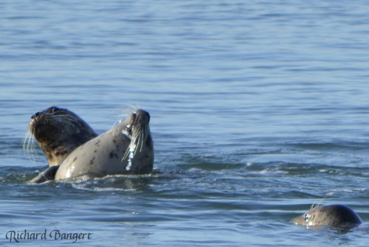
This winter, the seals favor the afternoon for getting out of the water. Their numbers can vary from a dozen to a recent high of over three dozen. It is the only haul-out site in the East Bay between Yerba Buena Island and the marshlands of Fremont and Newark near the Dumbarton Bridge, both of which require watercraft for public viewing access. The seals at Alameda Point can be viewed from the Bay Trail.
The National Marine Fisheries Service (NMFS or Fisheries Service) issued a permit to the Water Emergency Transportation Authority (WETA) on February 25, 2015, for proposed in-water dock construction activities at Alameda Point that may impact resident harbor seals.
In its permit, they brushed off concerns of the Sierra Club, the San Francisco Bay Conservation and Development Commission (BCDC), and many residents that removal of the old dock used by harbor seals as a haul out could cause them to abandon the area.
The Fisheries Service doesn’t seem bothered that the seals might abandon the area. They suggest the harbor seals could use a nearby rocky breakwater or a beach on Yerba Buena Island about four miles away. The Fisheries Service even went as far as belittling the dock structure and location preferred by the harbor seals as being “artificial” and “manmade,” even though examples of artificial wildlife habitat enhancements are widespread, some of them sanctioned by the Fisheries Service.
Western tip of Breakwater Island where Fisheries Service said harbor seals should go. This city-owned property is ill-suited to raising seal pups and not inviting as a resting site, as evidenced by where the seals currently go.
The Fisheries Service stated, “NMFS does not consider building an artificial harbor seal haul-out is a good conservation measure to compensate for the loss of the old floating dock that is being used as a haul-out by 10-20 harbor seals. The floating dock proposed to be removed is a manmade structure that is bound to disappear as it deteriorates and falls apart. To build another new structure without maintenance will likely have the same issue in the near future. Therefore, NMFS considers it better conservation practice not to construct a new structure just to replace the current deteriorating artificial one.”
The one remaining beam moored to old dock – similar to log booms used by harbor seals elsewhere to haul out.
No one suggested that conservation measures come “without maintenance.” Some periodic maintenance would obviously be necessary.
Fisheries Service philosophy out of touch
If “manmade” artificial landscape features were poor conservation measures, then we would have to assume the Fisheries Service would not approve of fish ladders in rivers and streams to aid fish migration. Nor would they have approved of the artificial reef constructed off the coast of Texas using decommissioned and cleaned ships, and decommissioned oil rigs. A thriving marine reef habitat — through artificial means — has been the result.
At Alameda Point, the entire least tern nesting site is artificial, from the imported sand, oyster shells, shelters and fence to the entire land mass underneath it created by filling in a marsh. Likewise, the least tern nesting island in the Hayward Shoreline marsh is artificially constructed and may someday be underwater. Both of these artificial sites are successful in aiding endangered birds by replacing habitat lost due to human development and uses.
The Fisheries Service response to the comments on the impacts of the ferry maintenance facility gives the appearance of being out of touch. Instead of calling for a small mitigation measure in the form of a new haul out by the agency that is altering the ecosystem, they have shifted the burden to the harbor seals. This is backwards. It sets the baseline conditions as “tomorrow” rather than “yesterday” before modern development ruined most of the shoreline habitat in the Bay.
But there is still hope. The Alameda City Council will have an opportunity at its Tuesday, March 3 meeting to rectify the pending lease agreement with WETA that fails to include provisions for the harbor seals. And a few weeks later, BCDC will have an opportunity to ensure that its permit for the project contains harbor seal haul-out requirements.
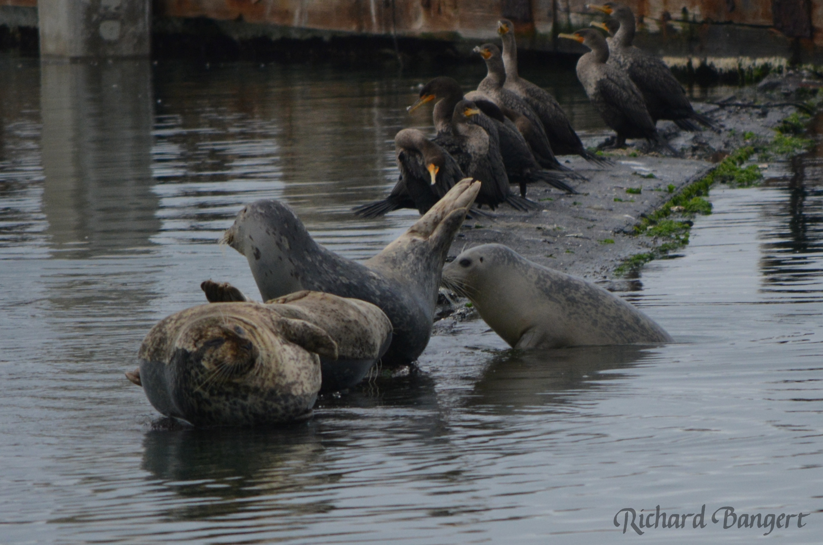
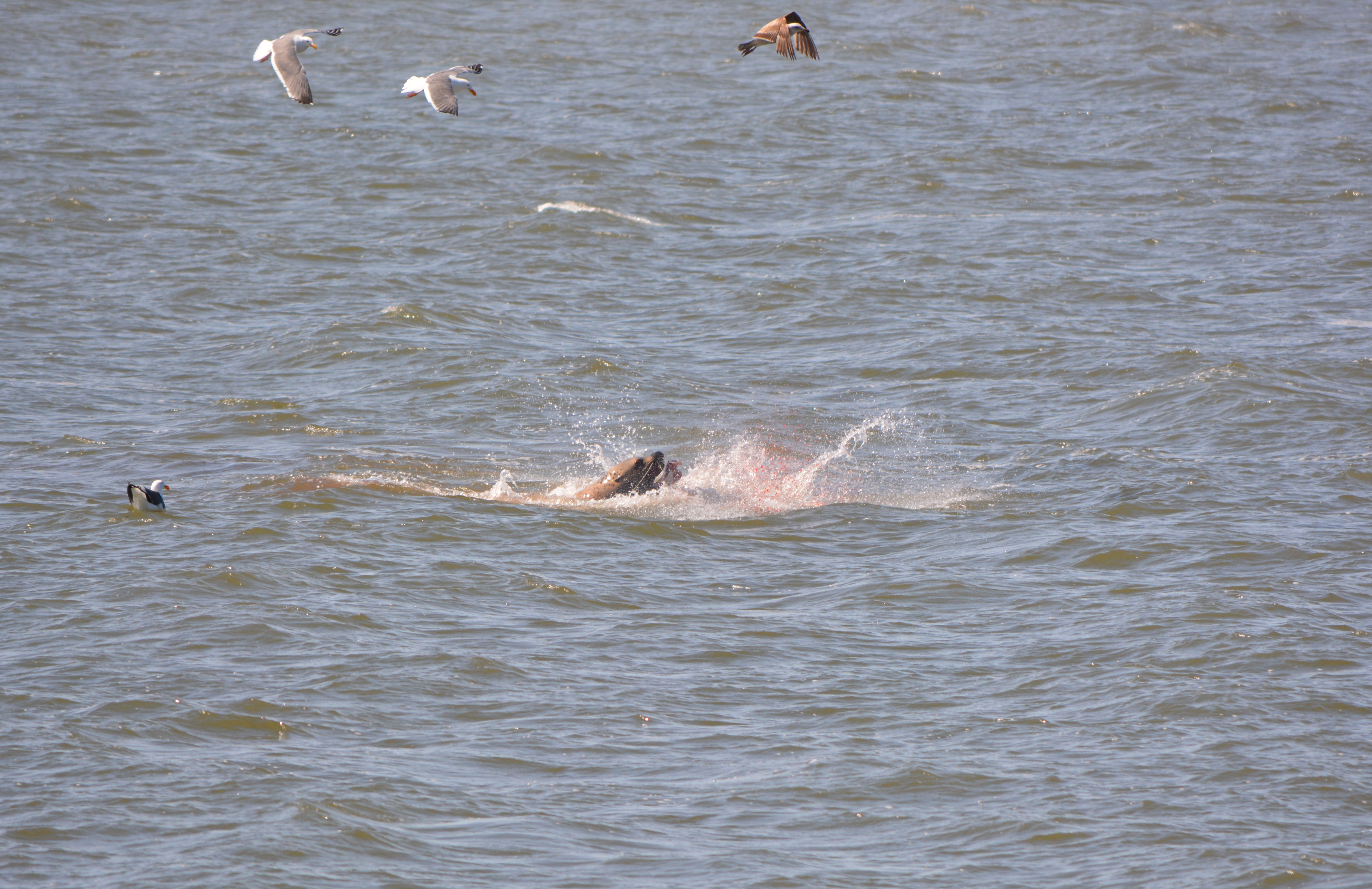
Harbor seal feeding on bat ray in Alameda Point Channel where new haul out could potentially be located.
Breakwater Island landscape that Fisheries Service and city of Alameda say is suitable harbor seal haul-out habitat.
Sierra Club comment letter to Alameda City Council on WETA lease
BCDC comment letter to National Marine Fisheries Service on WETA permit
Sierra Clubcomment letterto National Marine Fisheries Service on WETA permit
The San Francisco Bay Conservation and Development Commission (BCDC) gave its approval for the shoreline access provisions of the Veterans Affairs’ (VA) project at Alameda Point at its January 16, 2014 meeting. The VA submitted plans that include a public road with sidewalk and bike lane leading to the western shoreline, a one-acre parking and observation area at the shoreline, restrooms, drinking fountains, long term maintenance, and a shoreline easement for the city to construct the Bay Trail. The VA’s plan reflects collaboration with BCDC staff and the City of Alameda.
Some of the BCDC commissioners were concerned about the size of the undeveloped buffer area for the California Least Terns that nest on the former airfield, and the lack of public access on the proposed Bay Trail from April 1 to mid-August while the terns are present. Other commissioners were concerned that the VA and the Army Corps of Engineers had not finalized a plan to mitigate wetlands that the VA project will cover up.
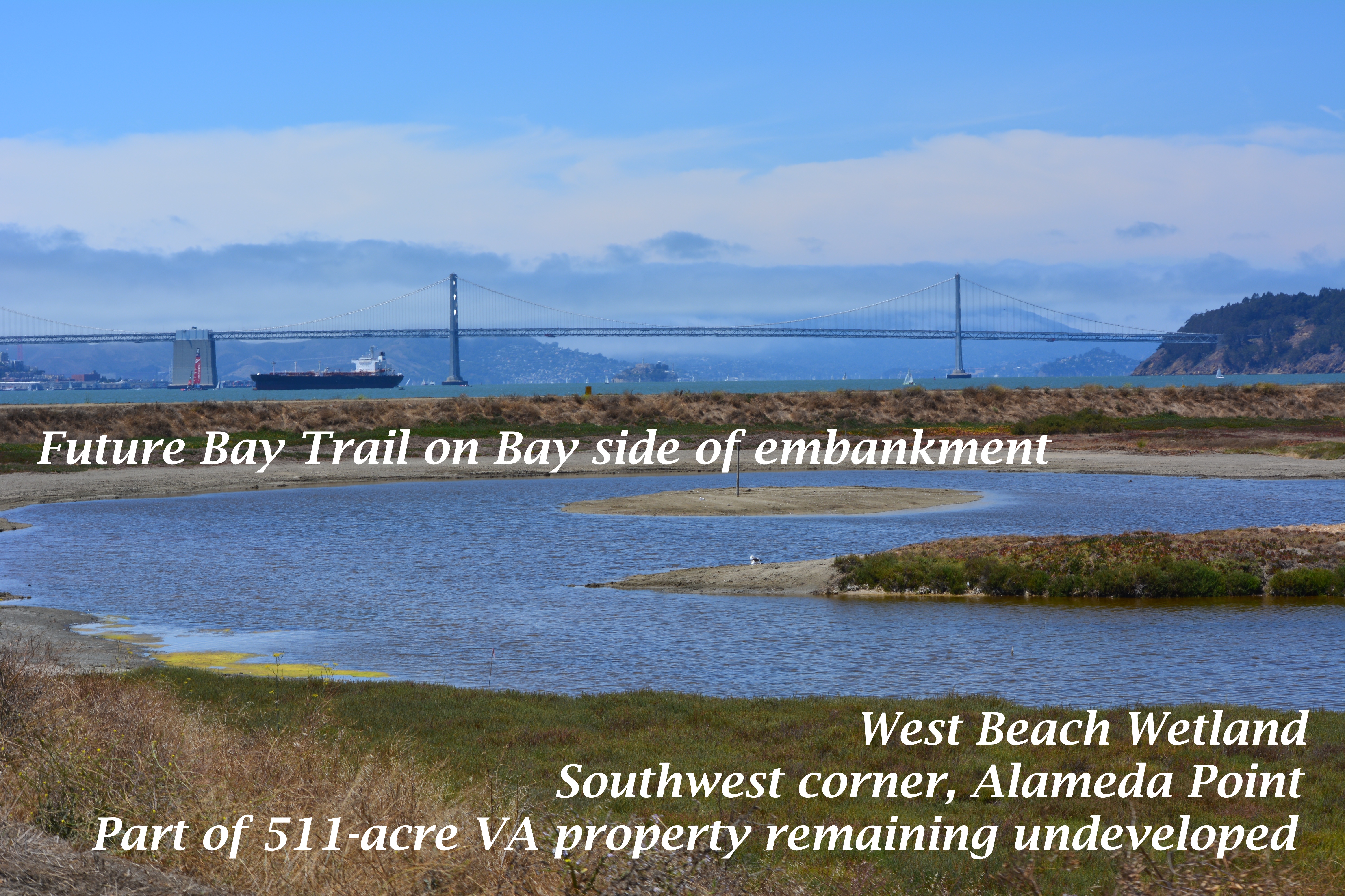
Part of the 511 acres that will be owned by the VA and remain undeveloped. Current restrictions call for prohibiting Bay Trail access to this area from April 1 to mid-August because of potential threats to least terns that nest about a half-mile to the east.
The following excerpts from the 18,000-word meeting minutes for this agenda item offer insight into the long and sometimes contentious effort to construct a VA outpatient clinic, offices, and a new national cemetery at Alameda Point.
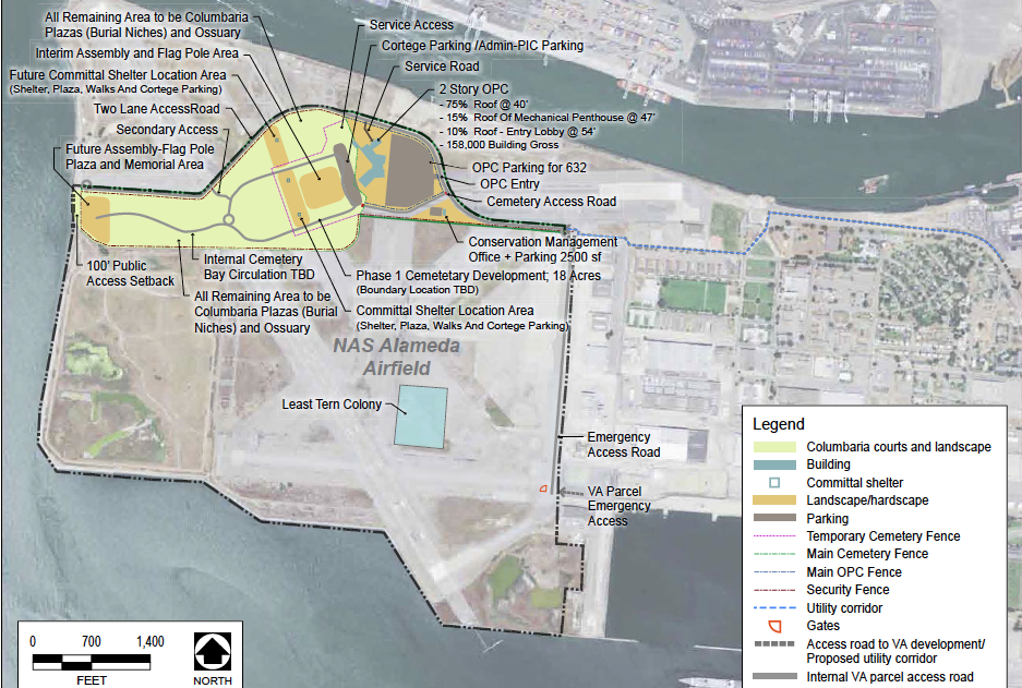
West Beach Wetland area (partially shown in photo above) is on the lower left portion of this map. Click on map to enlarge.
Commissioner Geoffrey Gibbs enquired, “I would like to know from the city of Alameda how these plans are consistent with the city’s hope for a mixed-use development on or near the site.” Alameda Point Chief Operating Officer Jennifer Ott responded, “We’ve been working with the VA for several years and they are consistent with our plans,” Ott said, “and the city has planned over 150 acres of additional park space, passive, open space that by building that road will actually help us bring down the cost of our development of that space to the north. It is a huge help to us to be able to implement additional significant regional open space facilities.”
Commissioner Jim McGrath questioned the VA about the need to prohibit access to the shoreline during the Least Tern breeding season from April 1 to mid-August. McGrath said, “I’m excited that something has been found to work in the long term to manage and preserve the wildlife area. I would love to see it expanded. When I began looking at the maps I said, boy, that Least Tern colony is a long way from the shoreline, over a mile.
“While I absolutely support science-based information that protects nesting areas for endangered species as warranting the highest level of protection, I don’t necessarily see the analytical gap bridged here between the potential for impact, the need for management and the need for, on a long term, restrictions of this nature.
“Some of the research that I’ve seen for the development of habitat areas within the restoration of the South Bay Salt Ponds, the research established that predation from avian species, particularly Western Gull, were the main threats to the Least Tern successful breeding.
“I know from my own experience that there has been successful breeding at fenced sites in southern California at Playa Del Rey and in Orange County; smaller sites on beaches with much less robust buffers.
“It raises in my mind the question of, would we not be better off with some active management of the Least Tern area that is science-based looking at the sources of predation, looks at the actual colony. I don’t want to pick on this project so much as say, if under the consistency review authority which is our single shot at trying to balance wildlife protection and provision of public access, we don’t ask those questions at this stage, we may miss the opportunity to try to achieve a better balance.
“I am a little bit troubled with a mile buffer.”
Mr. Richard Crowe from the VA responded: “We spent several years negotiating with the U.S. Fish and Wildlife Service. From our research, there is no science or an adequate buffer from a development to a colony. There is science on adequate buffer between colony nests. There is a paucity of research in that area.
“The U.S. Fish and Wildlife Service was adamant and we’ve negotiated in good faith and they felt that that quarter mile, 1674 linear feet, was the necessary buffer for the human impacts potential on the Least Tern.
“We’ve negotiated as much as we could and in order to get a favorable biological opinion that those were the final buffers.”
Commissioner McGrath continued the dialogue: “I understand and sympathize with your dilemma but adamancy does not constitute peer-reviewed science. And while we don’t have the U.S. Fish and Wildlife Service here, I guess to some degree I do think of that as the independent analytical role of the staff and the Commission.
“I have no trouble with the provisions and the burden with the VA with the exception of, that may end up being de facto management of this system on a hands-off basis when that, in fact, is not the best thing for either habitat or public access.
“I don’t know what to do with that concern. It certainly bothers me.”
Mr. Crowe responded: “The biological opinion is subject to negotiated modification should any other new science come up or new position by the current managers. The development was going to be below that little bulge but the U.S. Fish and Wildlife Service felt that that was going to jeopardize the Least Tern and they were going to issue a jeopardy opinion, which would kill the project. We negotiated very well and successfully with the city of Alameda to move that development up and that satisfied the U.S. Fish and Wildlife Service and all parties agreed to that and I think that was our way forward.”
This photo shows part of the area on the VA property that was recently zoned Nature Reserve by the city of Alameda. The Bay Trail will pass through this area. The fenced-in 10-acre Least Tern nesting site is nearby to the right. The adult terns roost on pavement near where this photo was taken, which is outside the fenced nesting area. Pedestrians and cyclists coming this close to roosting terns would cause them to flush, which is the reason for the trail closure during the nesting season. How close is too close has yet to be scientifically determined.
Jennifer Ott added, “From the City’s perspective we would have much rather have had a year-round trail. I can imagine the City approaching the VA at a future time, once things have settled, bringing this up again as an issue.”
Wetland Mitigation
The VA’s project will entail filling in about 11 acres of wetland. The VA will be required to mitigate the loss of wetland, but those plans have not yet been agreed to and approved by the U.S. Army Corps of Engineers. Some commissioners wanted to postpone the vote to approve the VA plans until they could see the wetland plans, even though the wetlands are outside BCDC’s jurisdiction.
Runway Wetland in foreground is the best area in which to add additional wetland as mitigation for losses in the VA developed area to the far right on the airfield (outside of view).
Commissioner Kathrin Sears said, “We look at the Least Tern in a different way because the birds fly. Wetlands can become connected to the Bay and have a broader impact on areas in our jurisdiction as sea level rises. I think there are different issues there that might make it appropriate for us to look at the wetlands.
Commission Chair R. Zachary Wasserman said, “Coming back to the issue of the wetlands that are outside of our jurisdiction, that are within the Corps’ jurisdiction; the issue being raised is, will the Least Terns – we are legitimately taking that into consideration because they’re migratory, they use the Bay, they use our jurisdiction. The question that has been posed is for the wetland that is outside our jurisdiction, which theoretically is used by shore birds; is that sufficient then to bring it within our consideration just as the Least Tern issue is?”
The VA’s Doug Roaldson commented: “We appreciate the [U.S. Army] Corps [of Engineers] and we have had numerous talks with you. We are clearly interested in those wetlands. We’ve had numerous discussions about a strategy. We’re still evaluating that strategy. We don’t know what’s happening and this is outside of your jurisdictional discussion right now. What’s the VA going to do? We’re going to take care of those wetlands. We’re either going to move them and we’ve got two very high quality wetlands on the property and they are very easy to mitigate into. We’ve had these discussions with the Corps.
“We’ve had a discussion, if we mitigate do we mitigate by phase or do we mitigate the entire site?”
The last comment offers insight into why the VA and Corps of Engineers have not yet agreed on a plan. The Corps wants the entire 11 acres of wetland mitigated at the beginning of the project, even though some of those acres won’t be impacted for decades when more of the columbarium is built out. The VA, on the other hand, wants to pay for the mitigation when the wetlands are actually filled in.
Whether the wetlands are mitigated in phases or all at once, the plan will have to be agreed upon when the VA begins their project. BCDC’s approval contains special conditions that require Corps of Engineers approval of a wetland plan at the project’s commencement.
BCDC staff member Jaime Michaels said, “I just want to point out given the conversation we’ve been having [about wetland mitigation], there is also a condition and it’s Special Condition II.C that talks about the need for the VA to get other local, federal and state approvals before they begin their work. That would include the Corps of Engineers’ approval.”
A motion was made and seconded to approve the VA’s project as being consistent with state law, in this case the San Francisco Bay Plan, as required under the federal Coastal Zone Management Act. On a roll call vote, the motion passed with 13-Yes, 2-No, and 4-Abstain.
The property is slated to be transferred from the Navy to the Department of Veterans Affairs in 2014.
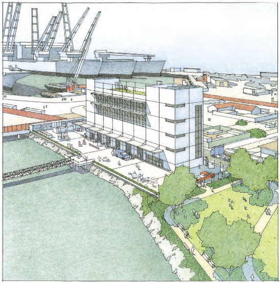
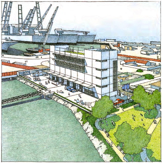
A public hearing is scheduled for January 6, 2014 in San Francisco to take comments on the proposed facility for Bay ferries at Alameda Point. It is the Bay Conservation and Development Commission (BCDC) Design Review Board’s first hearing to determine if the project complies with guidelines for ensuring maximum public shoreline access, preserving scenic views, and enhancing the shoreline visual experience through appropriate design appearance.
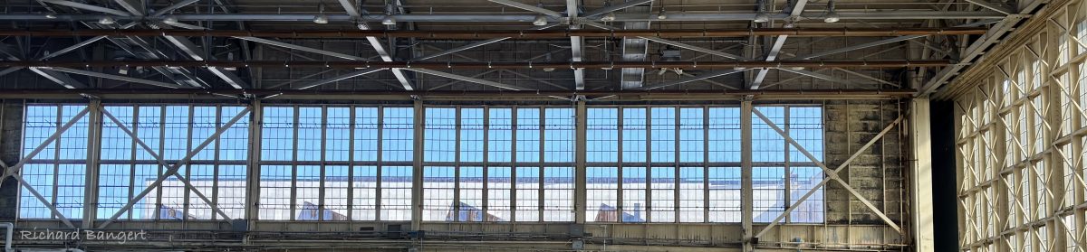
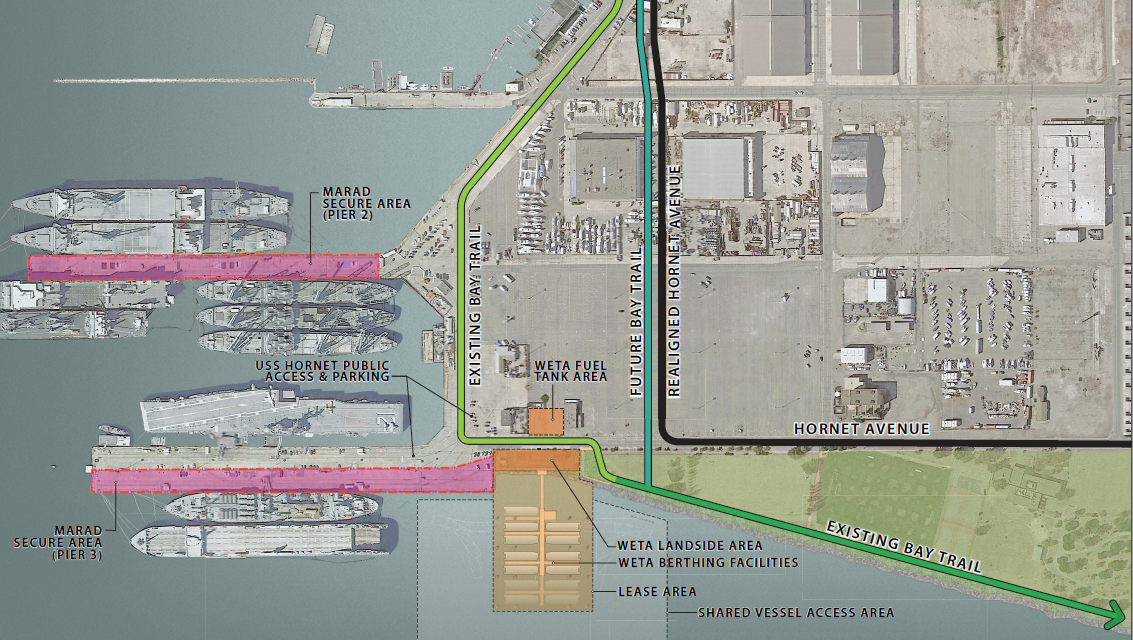
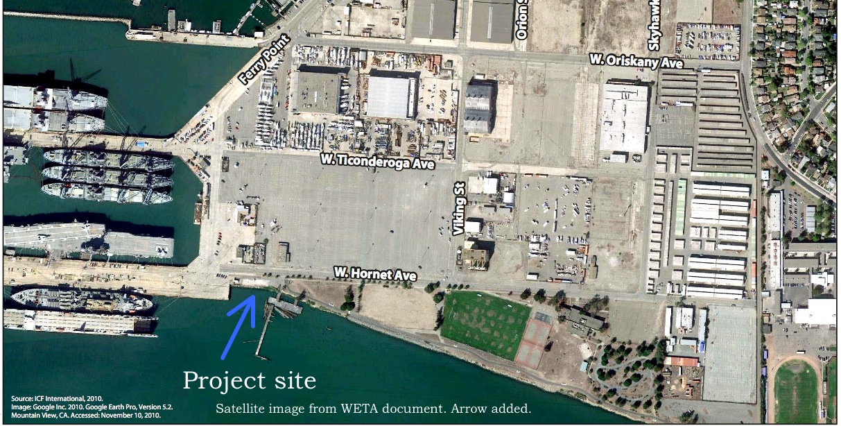
Located on Hornet Avenue at Ferry Point Road near the U.S.S. Hornet on a four-acre site to be leased from the City of Alameda, the facility will service and maintain ferries owned by the Water Emergency Transit Authority (WETA) operating in the Central Bay. The project will include a 70-foot-tall four story building for maintenance, dispatch, and administrative tasks, a service yard, and floating berthing facilities for 12 vessels. Demolition of the old recreational dock and retaining wall, and dredging of the berthing area is scheduled to begin in the summer of 2014.
Click on image to enlarge.
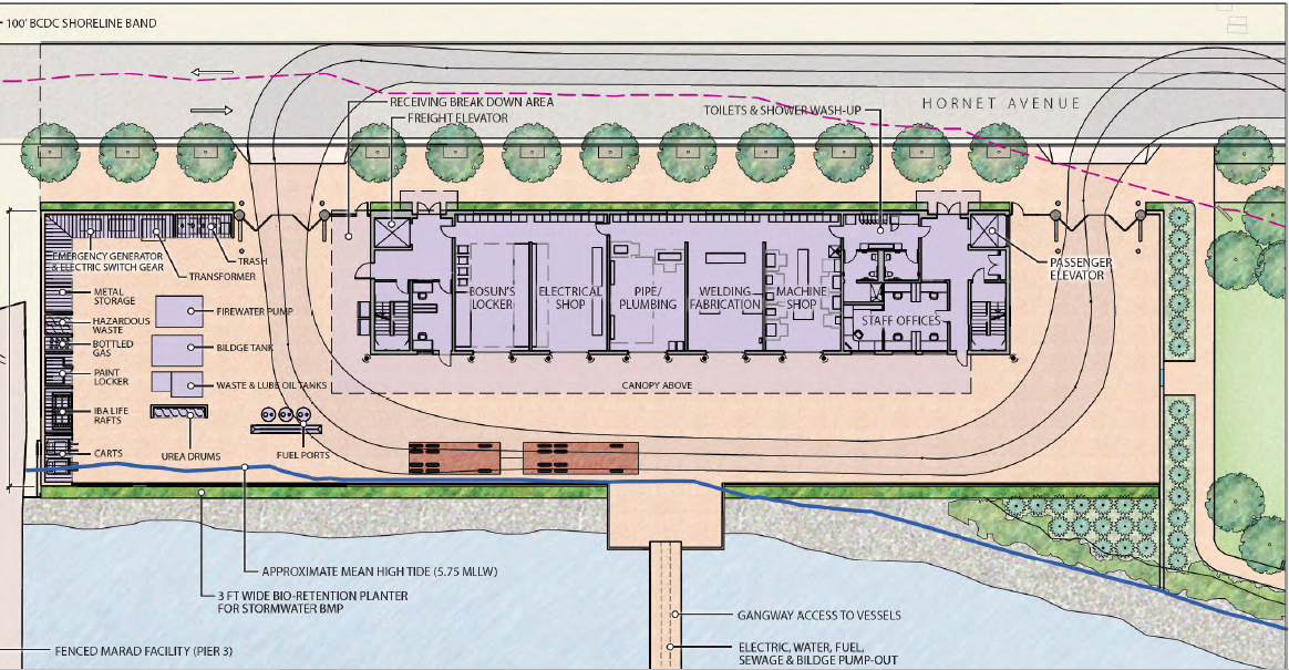
A variety of activities will take place at the facility, including refueling ferries from new underground fuel tanks, bilge and sewer pump-out, fluid replenishment, repair and replacement of vessel equipment, trash disposal, cleaning and painting of vessels, and storage and replenishment of concessionary items for passengers.
Click on image to enlarge.
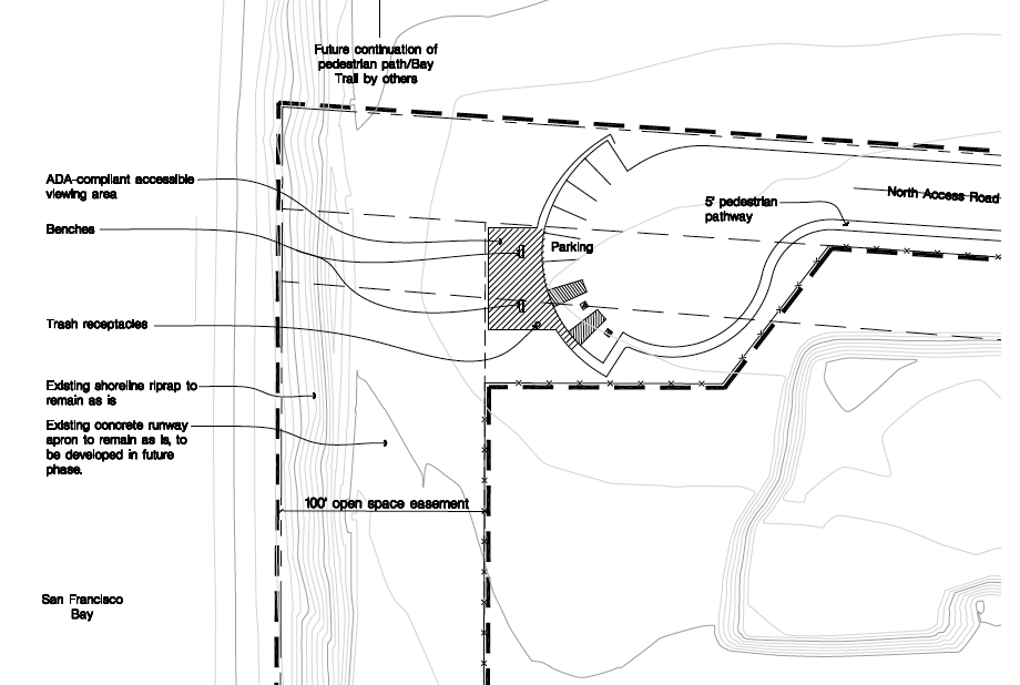
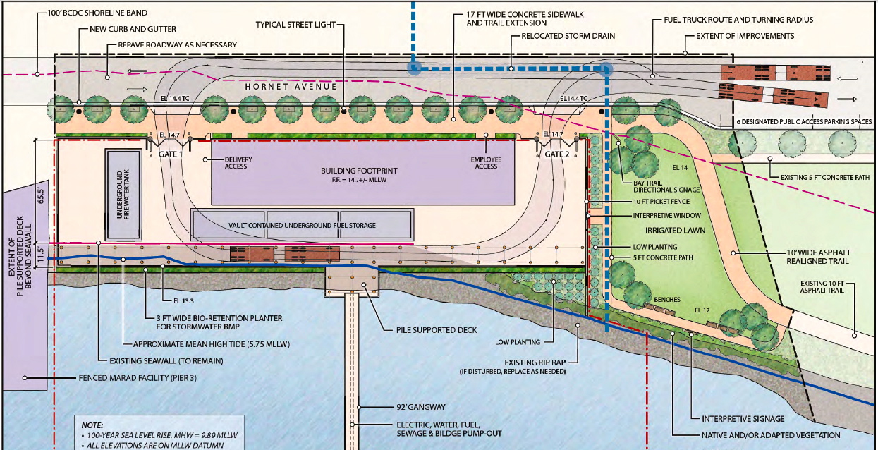
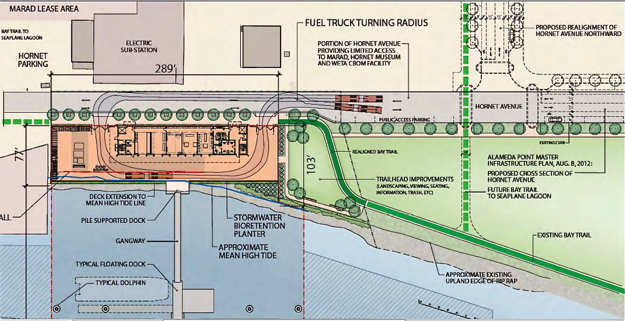
WETA, in consultation with BCDC staff, proposes enhancements to the adjacent park area owned by the city. The proposal that BCDC is seeking comment on would realign and extend the existing Bay Trail so that it better serves as a connection to the U.S.S. Hornet Museum and the existing public access areas through the maritime ship site to the Seaplane Lagoon. Approximately 100 feet of the existing trail and path would be removed and replaced with approximately 145 feet of new 10-foot wide trail and path.
According to the BCDC staff report, “In addition, a new 17-foot-wide extension of the Bay Trail would be constructed along the 289-foot northern length of the project site along Hornet Avenue. This portion of the trail would include a two-foot-wide landscaped area adjacent to the project site, 12 new street trees in three-foot by six-foot tree wells adjacent to a six-inch curb and an 11.5-foot-wide pedestrian and bicycle trail. Beyond this area and through the Hornet and MARAD [maritime ship] site, signage would indicate the route for pedestrians and bicyclists.”
Click on image to enlarge.
The BCDC report continues by saying, “Approximately 6,850 square feet of the park would be landscaped between the realigned trail and the project site, including irrigated turf and low lush planting with a break in the landscaping provided to create ‘windows’ into the work yard. Interpretive signage would describe the unique working waterfront activities. Nine trees in three clusters are proposed to better define the spatial qualities of the setting and to provide shade and visual interest. In addition, six benches are planned along the shoreline. Opposite the benches will be an interpretive sign describing the role and function of the WETA berthing facilities.”
Click on image to enlarge.
One impact not accounted for in WETA’s state and federal environmental reviews is the displacement of harbor seals when WETA removes the old dock that is used as a haul out. Constructing an anchored floating platform nearby for harbor seals and birds would make up for the old dock that has served as a wildlife resting site since base closure 16 years ago. WETA should add a wildlife platform to its budget. Wildlife and the visiting public will greatly appreciate it.
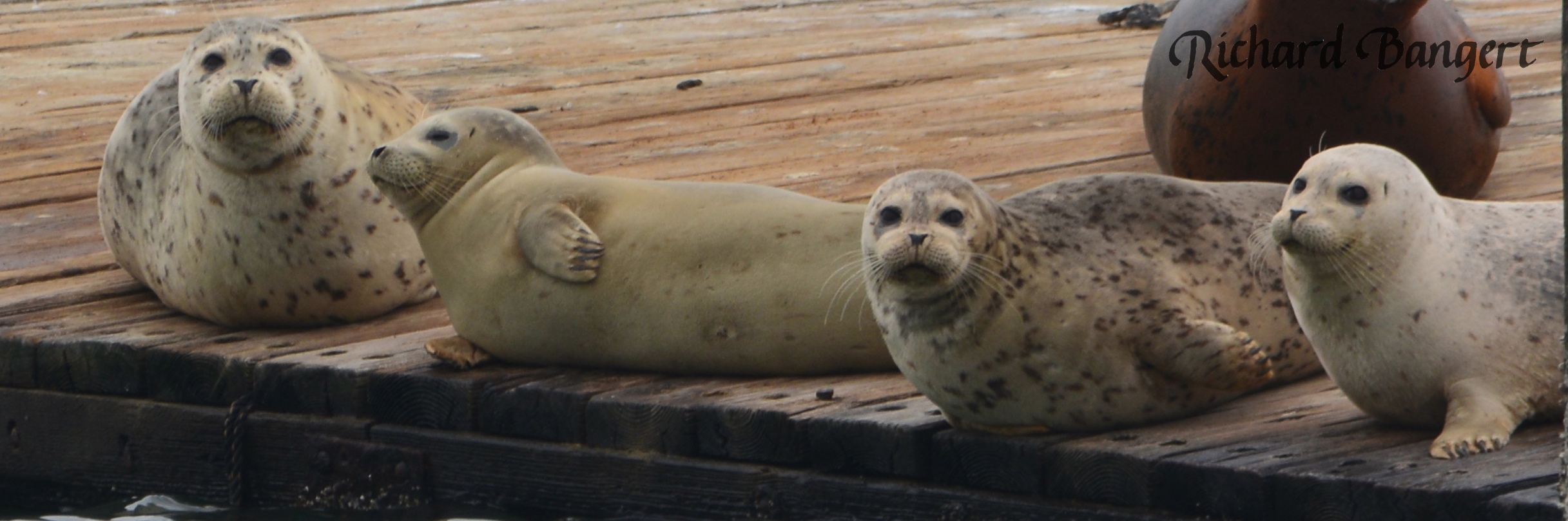
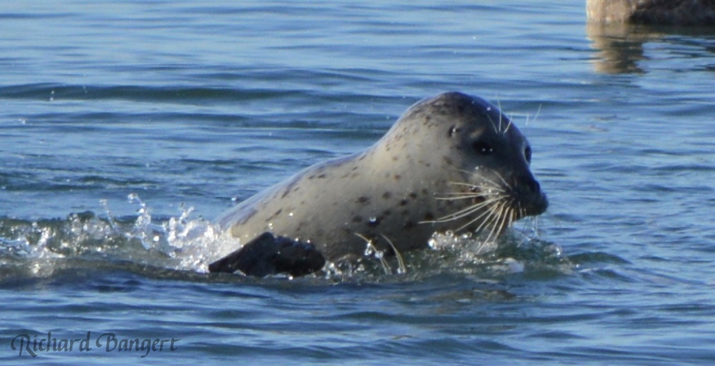
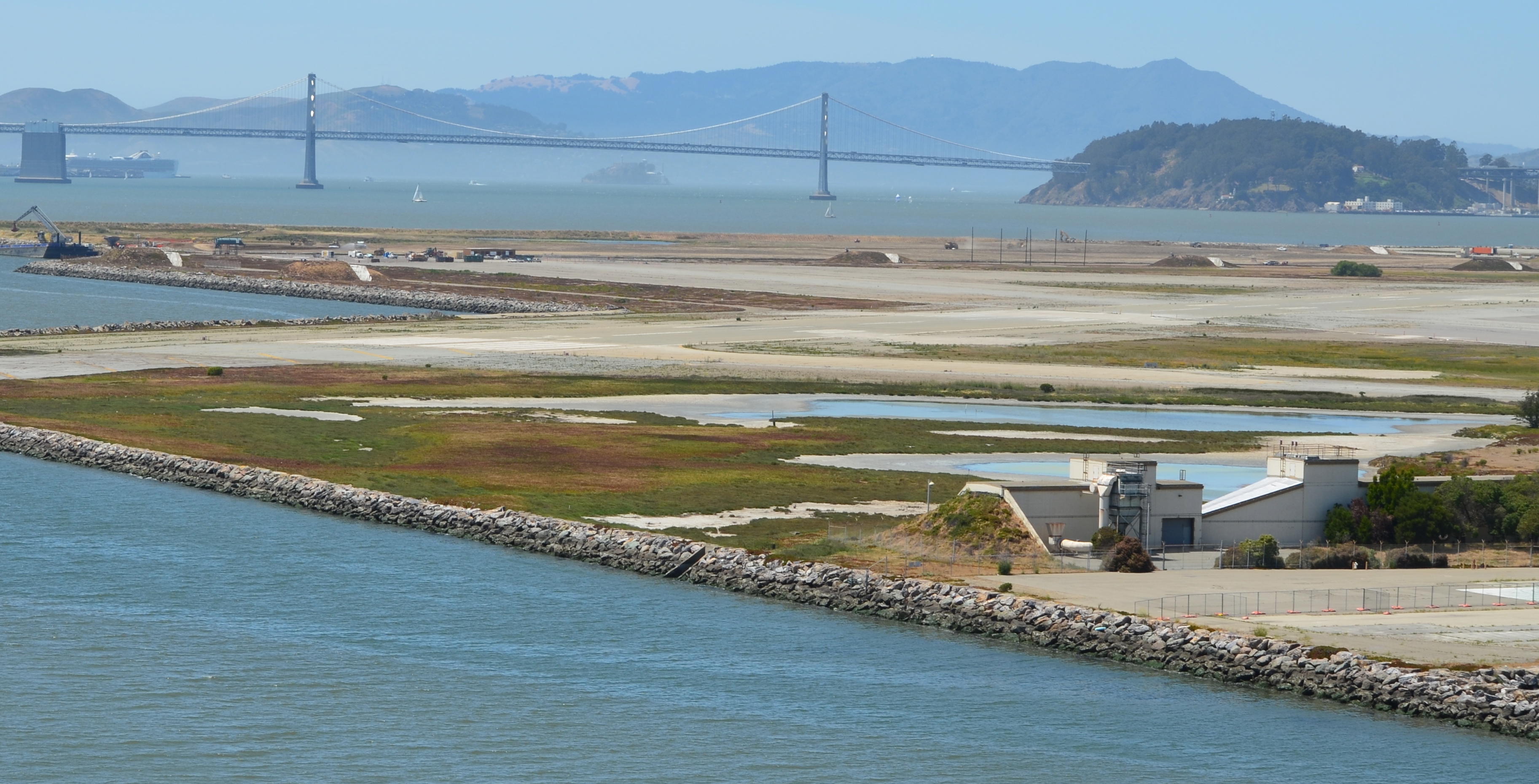
Harbor Seals on Alameda Point dock in the Spring of 2013. Located on Alameda Point’s south side in the Inner Harbor, the dock will be demolished to build the new ferry maintenance facility. San Francisco Bay is in the background beyond the breakwater. Copyrighted photo by Richard Bangert.
The Monday, January 6, 2014 hearing will be held at the BCDC McAteer-Petris Conference Room, 455 Golden Gate Avenue, Suite 10600, San Francisco. The hearing begins at 6:30 pm. For information about the meeting, the public is directed to contact Ellen Miramontes at (415) 352-3643 orellenm@bcdc.ca.gov.
Looking north across Site 2 with Port of Oakland and Bay Bridge in background. Area to the left of landfill embankment will be covered with clean soil. Unlined industrial waste disposal pits lie underground.
The environmental remediation work plan for the Site 2 waste disposal area was finally introduced for public comment in early May after a decade on the Superfund list. During the 60-day public comment period that ended July 9, numerous agencies, groups, and individuals offered their critique of the Navy’s plans to install a suitable soil cover over the substandard soil cover that currently overlays the waste. Digging up the waste and hauling it away was ruled out in 2010 because of the $900 million price tag. Exclusionary security fencing, soil gas vents, wetlands, and geological/seismic stability due to close proximity to the Bay are issues receiving attention.
Taking samples of Site 2 landfill contents in 2005. Navy contractor photo.
The Navy’s industrial waste dump on Alameda Point’s southwestern corner has been the subject of environmental concern since the 1980s when the Water Board ordered the dump closed. The mid-1980s were a little more than a decade after passage of the federal Clean Water Act and the emerging environmental awareness and new regulations requiring underground waste sites to be lined. The Alameda Point dump is composed of various unlined cells, or pits, where all manner of aircraft parts and maintenance chemicals and debris were dumped, along with waste material from the luminescent dial and marker painting that used radium-226.
Exclusionary fencing
The Navy’s work plan includes a security fence and tall PVC pipes to vent methane gas. Golden Gate University’s Center on Urban Environmental Law (CUEL) has been following open space planning at Alameda Point and offered comments on the proposed security fence and the 10-foot tall soil gas vents. With collaboration from UCLA’s Landscape Architecture Department they created two composite drawings illustrating the stigmatizing effect that a fence would have on this wild open space with the Bay and San Francisco skyline in the background. The Navy has proposed the fence, even though the newly seeded clean soil cap will be safe to walk on. Protection of the soil, gas vents, and monitoring equipment was the reason given for the fence.
Composite drawing illustrating fence and 10-foot tall soil gas vents at Site 2 when Navy completes work. Image simulations produced for Center on Urban Environmental Law by Janet Wolsborn and Natural Resource Planning and Design.
Image simulation of Site 2 without security fence. Showing two-foot gas vents, trail, and soil cover and embankment seeded with native grasses and wildflowers. Produced for Center on Urban Environmental Law by Janet Wolsborn and Natural Resource Planning and Design.
The law group also secured the help of Pangea Environmental Services to investigate the necessity of the security fence and obtrusive gas vents. Pangea interviewed city employees and other personnel responsible for oversight of four closed Bay Area landfills that have been converted to open space and recreational uses: Shoreline Park in the City of Mountain View; Sunnyvale Landfill in Sunnyvale; Oyster Point Park in San Leandro; and Cesar Chavez Park in Berkeley. Only the Sunnyvale site has a fence, but the gates are open during the day and allow free access. “The interviewees all reported that they could not recall encountering any vandalism or other damage associated with public use to either monitoring wells/vapor probes, landfill cover materials or landfill gas venting systems during the periods (generally exceeding a decade) for which they had roles in managing the landfills.”
Pangea goes on to say, “[T]he proposed post-construction installation of permanent exclusionary fencing surrounding Site 2 is considered to contradict the ‘open space and recreational use’ land use restriction proposed in the RAWP (Remedial Action Work Plan), since a closed fenced area cannot be considered open space or be used for recreation. [T]here appears to be no technical basis for installation of a permanent exclusionary fence restricting public access to Site 2.”
The City of Alameda pointed to the Record of Decision for Site 2 that specifies certain land use restrictions such as “land disturbing activities,” which would prohibit digging, disturbing monitoring equipment, or building construction. Referring to the proposed fence, the city said that these restrictions “explicitly do not prohibit recreational uses.”
Site 2 (outlined in yellow on map above), comprising 110 acres, lies within the larger 549-acre parcel commonly known as the wildlife refuge in the runway area of the former Naval Air Station. The refuge is home to a nesting site for the endangered California Least Tern, which lies a few hundred yards east of Site 2. The US Fish & Wildlife Service currently manages the refuge and the tern colony. Continuing management of the refuge to protect the terns and their nesting area will mean that a fence and gates will always be necessary around the greater refuge boundaries to limit the introduction of mammals such as raccoons, opossums, skunks, and feral cats that could pose a threat to the terns during nesting season. The perimeter fence will also serve to control human access. Thus, a secondary fence within the refuge would be redundant in controlling access.
Both the US Environmental Protection Agency (EPA) and the Regional Water Quality Control Board (Water Board) called on the Navy to look for alternatives to the fence. The Water Board stated, “Although protection of human health and the environment is our primary goal, we request that alternatives be evaluated for the fence line and methane gas venting so that public concerns and environmental health might more naturally coexist with the other beneficial uses that are planned for the area.”
Landfill gas venting
PVC piping will be installed to vent methane gas created by decay of organic matter. Thirty of the proposed vents will be 10 feet high. However, since the predominant waste is industrial and not organic, the amount of methane produced is minimal. And after more than 25 years, methane production would be expected to be near the end of its life. The Navy’s project manager recently said that the current methane out-gassing is so low that it wouldn’t keep a flame lit if there was a flaring system, calling into question the number of vents required and their height.
The Water Board questioned the gas vents saying, “[I]t is unclear why the methane vents need to be so high.” The EPA, Pangea, and the City of Alameda echoed this concern suggesting that the methane gas venting system could be reengineered into a lower profile system.
The Bay Conservation and Development Commission (BCDC) had similar concerns about shoreline access and the visual experience of future trail users. They also called for more specifics on the overall design, including how the shoreline is suited to withstand sea level rise impacts, and specifics about drainage and other impacts on the wetlands from the new soil cover.
Wetlands connection to Bay
Western shore of Alameda Point looking south with San Francisco Bay on right. Site 2 begins where beach ends. Culvert connecting wetlands is in rip rap shore levee further south.
When the Navy extended the size of the base over 50 years ago to create the landfill site, they installed an underground 36” metal culvert that connects the North Pond on Site 2 to San Francisco Bay. Because the aging culvert does not enter the landfill portion of the site, the Navy is not addressing the soundness of the culvert, even though they are addressing wetlands issues at the site. The Navy’s presumed argument is that culvert improvements would be a “land improvement” that is outside the scope of environmental remediation requirements.
Both the Water Board and the EPA are arguing for the Navy to address the culvert issue. The Water Board stated, “We are very concerned about the age and integrity of the culvert that is the sole source of Bay water to the tidal wetlands. It is our understanding that the aged culvert is in very poor shape and may collapse any time. The value of this culvert became painfully apparent a year ago when some driftwood or other material clogged it up and impeded all tidal flow of brackish water to the wetland. In a matter of days the tidal wetland started drying up. Should that culvert collapse, the delays in rebuilding, from getting contracts to actual physical work, could be devastating and even fatal to the wetland flora and fauna.”
Partial view of Site 2 wetlands. Navy contractor photo.
The EPA said, “[T]here is no evaluation of the culvert to demonstrate that the culvert is appropriately sized or constructed to minimize the potential for future blockages, nor is there any provision for the periodic inspection and maintenance.” EPA went on to say, “Either the connection to the Bay needs to be reconstructed to reduce the potential for blockage or an obligation to periodically inspect the culvert and clear blockages needs to be included in the Operations and Maintenance plan. The details for the inspection and maintenance should be reviewed with BCDC as part of the Navy’s compliance with the substantive provisions of Bay Plan.”
Further addressing wetlands issues, the Water Board questioned, “Will there be an adequate number of wells effectively placed to monitor landfill leachate concentrations that might adversely affect the adjacent wetland species?”
Seismic stability
The hazardous waste pits on the south end of the site come within a few dozen yards of the Bay. The two longstanding concerns about proximity to the Bay have been chemical leaching into the water table, and failure of the seawall during an earthquake along the Hayward Fault. Well monitoring over the past 16 years shows that toxic chemical leaching is not a problem. However, the EPA is questioning the stability of the seawall and the earthen berm that surrounds the landfill containment area.
The EPA said, “It should be noted that based on the presented analyses the seawall along the southern coastal margin which is founded on liquefiable hydraulic fill and coarse-grained Young Bay Mud is prone to edge failure and lateral spreading.” They go on to say, “No remedial actions are proposed in the [Work Plan] to address these issues,” and they continue by saying, “[I]f the seawall is prone to failure and lateral spreading, it is unclear how further lateral spreading will be localized and will not distort the cover and result in depressions, drainage reversals or similar effects. Please address potential edge failure on spreading on southern coastal margin.” They also point out that the soil make-up of the berm around the landfill has not been characterized, leaving another question mark about seismic stability.
Site 2 geology cross section depicting western shoreline with features similar to southern shoreline addressed in EPA comments. 1 of 2 images. Navy illustration from 2007.
Illustration of geologic features looking north along western shoreline showing features similar to southern shoreline that raised concerns with EPA over seismic readiness. Navy illustration from 2007.
The EPA mentions reinforcement options such as “cement deep soil mixing and jet-grouting,” and calls on the Navy to clarify whether they think perimeter slope failure in an earthquake is an acceptable long term risk, in lieu of underground seismic reinforcements. They also point out that the work plan does not analyze consequences of future expected sea level rise.
The Navy has until August 24 to respond to comments and incorporate changes or additions to the plan in their final draft. The regulators and the Navy will meet periodically prior to the August 24 deadline. A 30-day final review by the Navy and regulatory agencies will follow. Work on the site is scheduled to begin on October 1 and be completed by summer of 2013. Completion could be delayed if the seeding of the soil cover cannot be accomplished during the rainy season.
Below is a photo gallery of Palo Alto’s Byxbee Park, which is built over a landfill waste site at the edge of San Francisco Bay. No exclusionary fencing.
“The Navy provided a more current explanation of the future redevelopment of IR Site 2, indicating that even under Department of Veterans Affairs (VA) ownership that IR Site 2 would be a wildlife refuge.”
“[T]he purpose of the multilayer soil cover is to control specific site risk through the prevention of direct contact by either humans or ecological receptors (e.g., burrowing animals).”
January 15, 2008, Minutes from regulatory agency and Navy “Resolution Meeting” on the Feasibility Study for Site 2