
The environmental remediation work plan for the Site 2 waste disposal area was finally introduced for public comment in early May after a decade on the Superfund list. During the 60-day public comment period that ended July 9, numerous agencies, groups, and individuals offered their critique of the Navy’s plans to install a suitable soil cover over the substandard soil cover that currently overlays the waste. Digging up the waste and hauling it away was ruled out in 2010 because of the $900 million price tag. Exclusionary security fencing, soil gas vents, wetlands, and geological/seismic stability due to close proximity to the Bay are issues receiving attention.

The Navy’s industrial waste dump on Alameda Point’s southwestern corner has been the subject of environmental concern since the 1980s when the Water Board ordered the dump closed. The mid-1980s were a little more than a decade after passage of the federal Clean Water Act and the emerging environmental awareness and new regulations requiring underground waste sites to be lined. The Alameda Point dump is composed of various unlined cells, or pits, where all manner of aircraft parts and maintenance chemicals and debris were dumped, along with waste material from the luminescent dial and marker painting that used radium-226.
Exclusionary fencing
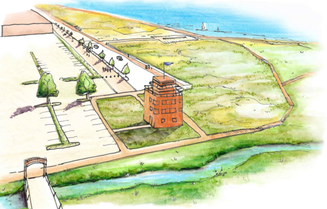
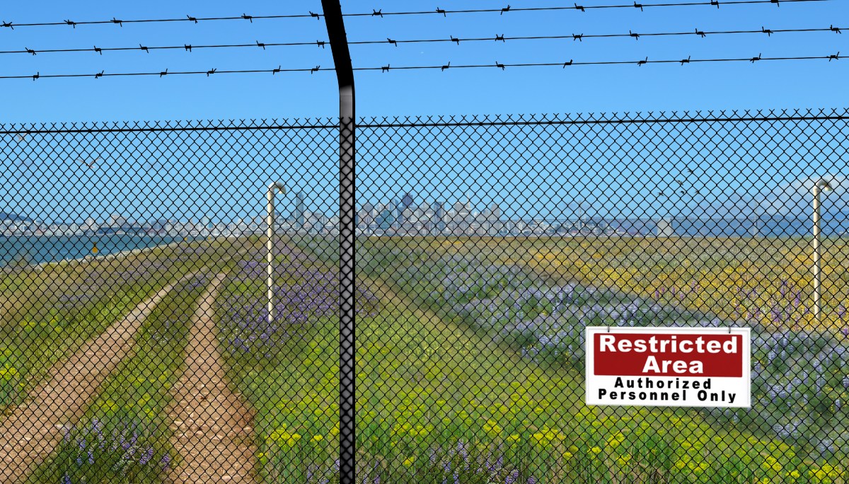
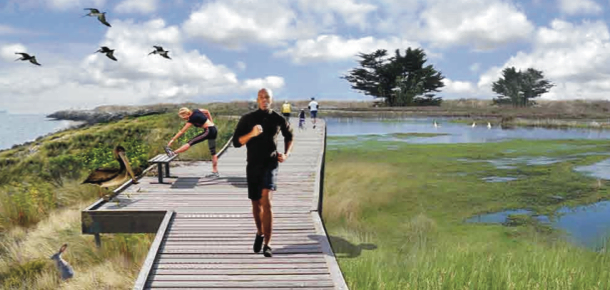
The Navy’s work plan includes a security fence and tall PVC pipes to vent methane gas. Golden Gate University’s Center on Urban Environmental Law (CUEL) has been following open space planning at Alameda Point and offered comments on the proposed security fence and the 10-foot tall soil gas vents. With collaboration from UCLA’s Landscape Architecture Department they created two composite drawings illustrating the stigmatizing effect that a fence would have on this wild open space with the Bay and San Francisco skyline in the background. The Navy has proposed the fence, even though the newly seeded clean soil cap will be safe to walk on. Protection of the soil, gas vents, and monitoring equipment was the reason given for the fence.


The law group also secured the help of Pangea Environmental Services to investigate the necessity of the security fence and obtrusive gas vents. Pangea interviewed city employees and other personnel responsible for oversight of four closed Bay Area landfills that have been converted to open space and recreational uses: Shoreline Park in the City of Mountain View; Sunnyvale Landfill in Sunnyvale; Oyster Point Park in San Leandro; and Cesar Chavez Park in Berkeley. Only the Sunnyvale site has a fence, but the gates are open during the day and allow free access. “The interviewees all reported that they could not recall encountering any vandalism or other damage associated with public use to either monitoring wells/vapor probes, landfill cover materials or landfill gas venting systems during the periods (generally exceeding a decade) for which they had roles in managing the landfills.”
Pangea goes on to say, “[T]he proposed post-construction installation of permanent exclusionary fencing surrounding Site 2 is considered to contradict the ‘open space and recreational use’ land use restriction proposed in the RAWP (Remedial Action Work Plan), since a closed fenced area cannot be considered open space or be used for recreation. [T]here appears to be no technical basis for installation of a permanent exclusionary fence restricting public access to Site 2.”
The City of Alameda pointed to the Record of Decision for Site 2 that specifies certain land use restrictions such as “land disturbing activities,” which would prohibit digging, disturbing monitoring equipment, or building construction. Referring to the proposed fence, the city said that these restrictions “explicitly do not prohibit recreational uses.”
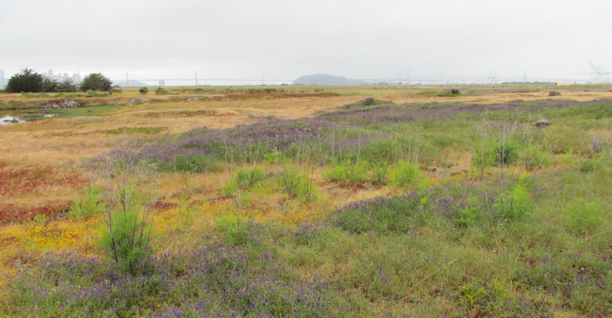
Site 2 (outlined in yellow on map above), comprising 110 acres, lies within the larger 549-acre parcel commonly known as the wildlife refuge in the runway area of the former Naval Air Station. The refuge is home to a nesting site for the endangered California Least Tern, which lies a few hundred yards east of Site 2. The US Fish & Wildlife Service currently manages the refuge and the tern colony. Continuing management of the refuge to protect the terns and their nesting area will mean that a fence and gates will always be necessary around the greater refuge boundaries to limit the introduction of mammals such as raccoons, opossums, skunks, and feral cats that could pose a threat to the terns during nesting season. The perimeter fence will also serve to control human access. Thus, a secondary fence within the refuge would be redundant in controlling access.
Both the US Environmental Protection Agency (EPA) and the Regional Water Quality Control Board (Water Board) called on the Navy to look for alternatives to the fence. The Water Board stated, “Although protection of human health and the environment is our primary goal, we request that alternatives be evaluated for the fence line and methane gas venting so that public concerns and environmental health might more naturally coexist with the other beneficial uses that are planned for the area.”
Landfill gas venting
PVC piping will be installed to vent methane gas created by decay of organic matter. Thirty of the proposed vents will be 10 feet high. However, since the predominant waste is industrial and not organic, the amount of methane produced is minimal. And after more than 25 years, methane production would be expected to be near the end of its life. The Navy’s project manager recently said that the current methane out-gassing is so low that it wouldn’t keep a flame lit if there was a flaring system, calling into question the number of vents required and their height.
The Water Board questioned the gas vents saying, “[I]t is unclear why the methane vents need to be so high.” The EPA, Pangea, and the City of Alameda echoed this concern suggesting that the methane gas venting system could be reengineered into a lower profile system.
The Bay Conservation and Development Commission (BCDC) had similar concerns about shoreline access and the visual experience of future trail users. They also called for more specifics on the overall design, including how the shoreline is suited to withstand sea level rise impacts, and specifics about drainage and other impacts on the wetlands from the new soil cover.
Wetlands connection to Bay

When the Navy extended the size of the base over 50 years ago to create the landfill site, they installed an underground 36” metal culvert that connects the North Pond on Site 2 to San Francisco Bay. Because the aging culvert does not enter the landfill portion of the site, the Navy is not addressing the soundness of the culvert, even though they are addressing wetlands issues at the site. The Navy’s presumed argument is that culvert improvements would be a “land improvement” that is outside the scope of environmental remediation requirements.
Both the Water Board and the EPA are arguing for the Navy to address the culvert issue. The Water Board stated, “We are very concerned about the age and integrity of the culvert that is the sole source of Bay water to the tidal wetlands. It is our understanding that the aged culvert is in very poor shape and may collapse any time. The value of this culvert became painfully apparent a year ago when some driftwood or other material clogged it up and impeded all tidal flow of brackish water to the wetland. In a matter of days the tidal wetland started drying up. Should that culvert collapse, the delays in rebuilding, from getting contracts to actual physical work, could be devastating and even fatal to the wetland flora and fauna.”

The EPA said, “[T]here is no evaluation of the culvert to demonstrate that the culvert is appropriately sized or constructed to minimize the potential for future blockages, nor is there any provision for the periodic inspection and maintenance.” EPA went on to say, “Either the connection to the Bay needs to be reconstructed to reduce the potential for blockage or an obligation to periodically inspect the culvert and clear blockages needs to be included in the Operations and Maintenance plan. The details for the inspection and maintenance should be reviewed with BCDC as part of the Navy’s compliance with the substantive provisions of Bay Plan.”
Further addressing wetlands issues, the Water Board questioned, “Will there be an adequate number of wells effectively placed to monitor landfill leachate concentrations that might adversely affect the adjacent wetland species?”
Seismic stability
The hazardous waste pits on the south end of the site come within a few dozen yards of the Bay. The two longstanding concerns about proximity to the Bay have been chemical leaching into the water table, and failure of the seawall during an earthquake along the Hayward Fault. Well monitoring over the past 16 years shows that toxic chemical leaching is not a problem. However, the EPA is questioning the stability of the seawall and the earthen berm that surrounds the landfill containment area.
The EPA said, “It should be noted that based on the presented analyses the seawall along the southern coastal margin which is founded on liquefiable hydraulic fill and coarse-grained Young Bay Mud is prone to edge failure and lateral spreading.” They go on to say, “No remedial actions are proposed in the [Work Plan] to address these issues,” and they continue by saying, “[I]f the seawall is prone to failure and lateral spreading, it is unclear how further lateral spreading will be localized and will not distort the cover and result in depressions, drainage reversals or similar effects. Please address potential edge failure on spreading on southern coastal margin.” They also point out that the soil make-up of the berm around the landfill has not been characterized, leaving another question mark about seismic stability.


The EPA mentions reinforcement options such as “cement deep soil mixing and jet-grouting,” and calls on the Navy to clarify whether they think perimeter slope failure in an earthquake is an acceptable long term risk, in lieu of underground seismic reinforcements. They also point out that the work plan does not analyze consequences of future expected sea level rise.
The Navy has until August 24 to respond to comments and incorporate changes or additions to the plan in their final draft. The regulators and the Navy will meet periodically prior to the August 24 deadline. A 30-day final review by the Navy and regulatory agencies will follow. Work on the site is scheduled to begin on October 1 and be completed by summer of 2013. Completion could be delayed if the seeding of the soil cover cannot be accomplished during the rainy season.
Below is a photo gallery of Palo Alto’s Byxbee Park, which is built over a landfill waste site at the edge of San Francisco Bay. No exclusionary fencing.
 |
| Byxbee Park on Palo Alto, CA landfill |
Links below about Site 2 on Alameda Point Environmental Report
Previous story on Navy plans for Site 2.
Story on wetlands at Site 2.
_______________________________________________________________________________

 through park")