Ospreys nesting at Alameda Point interrupted again in 2014

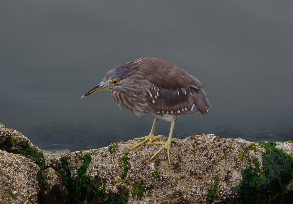
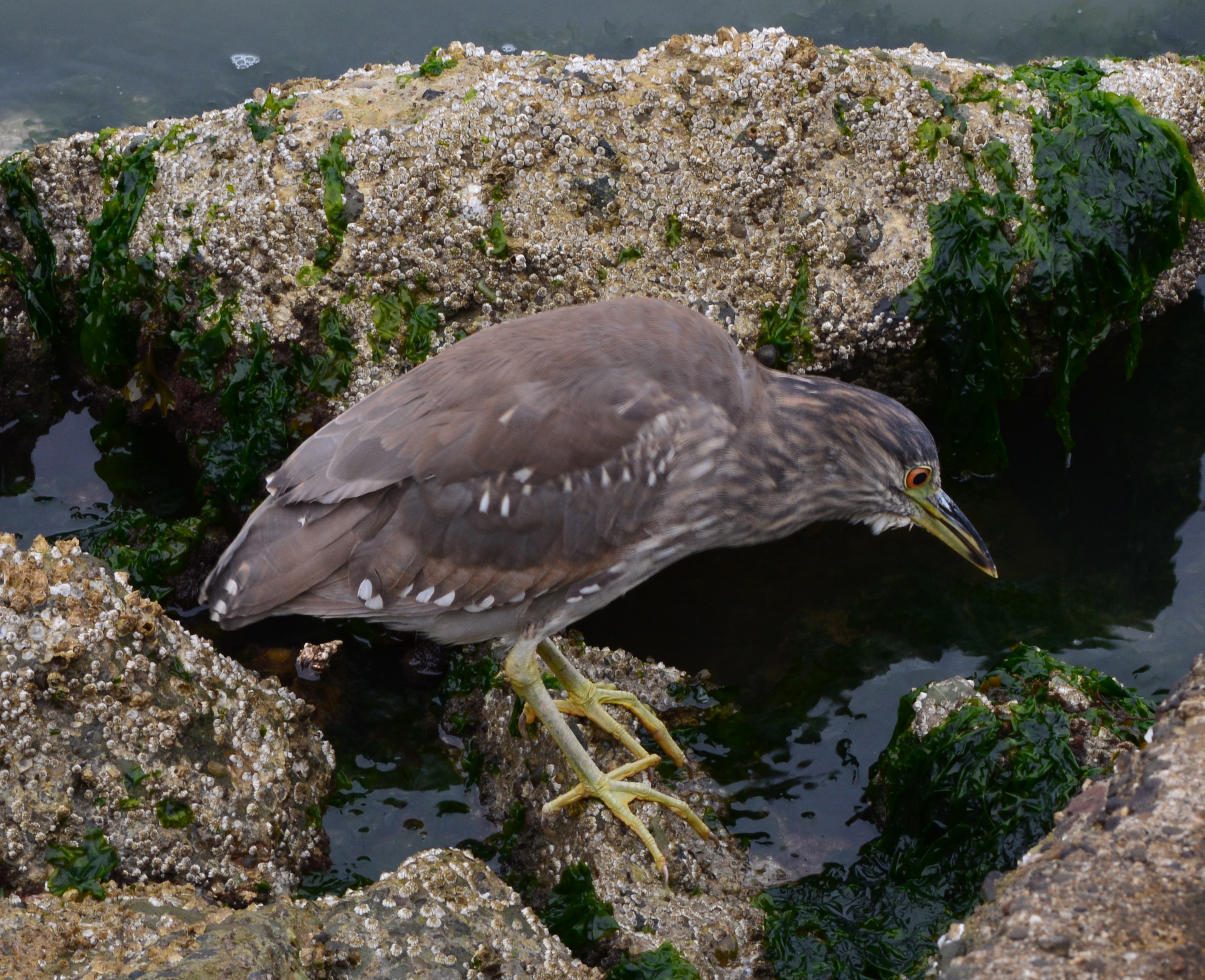
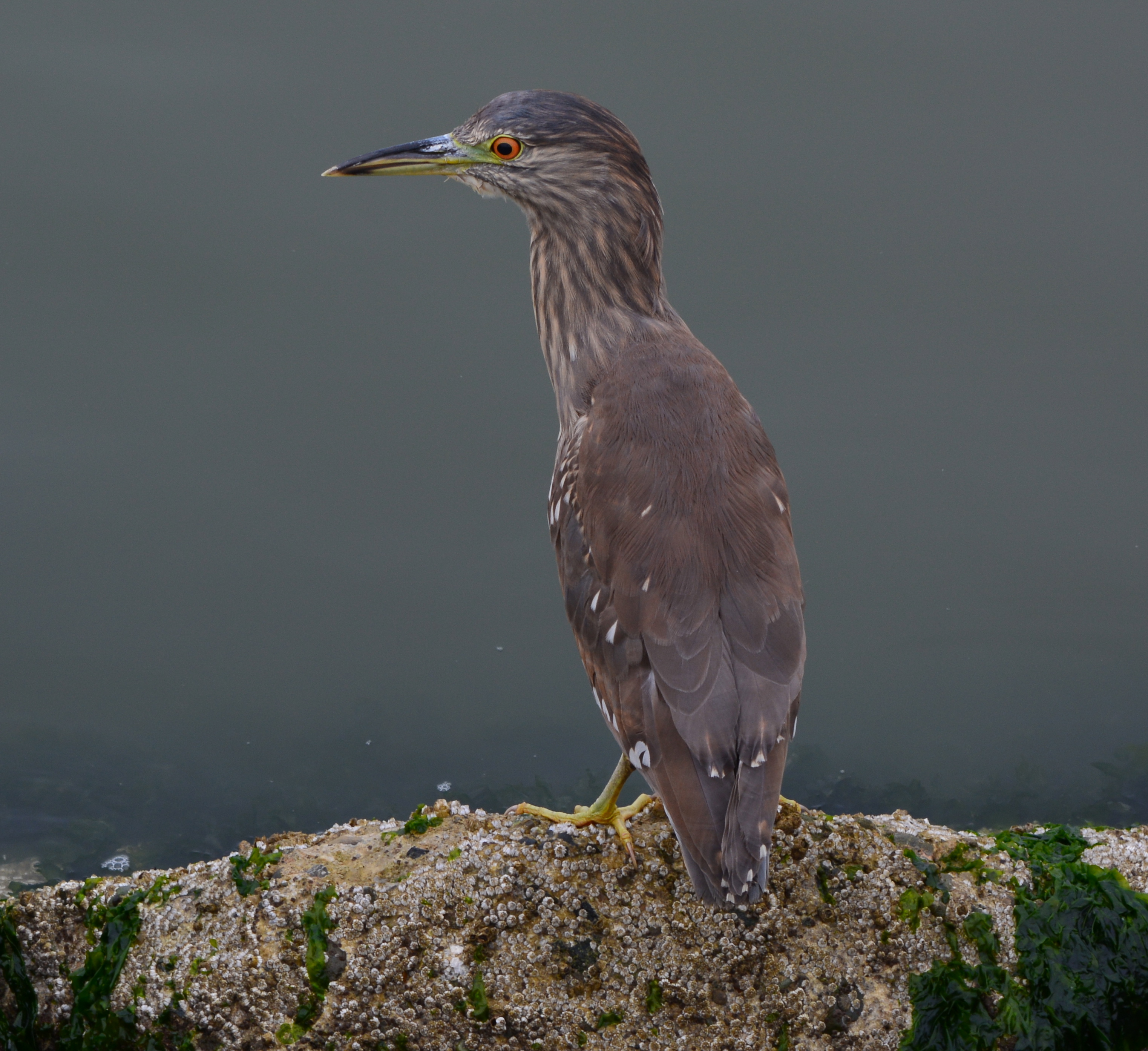
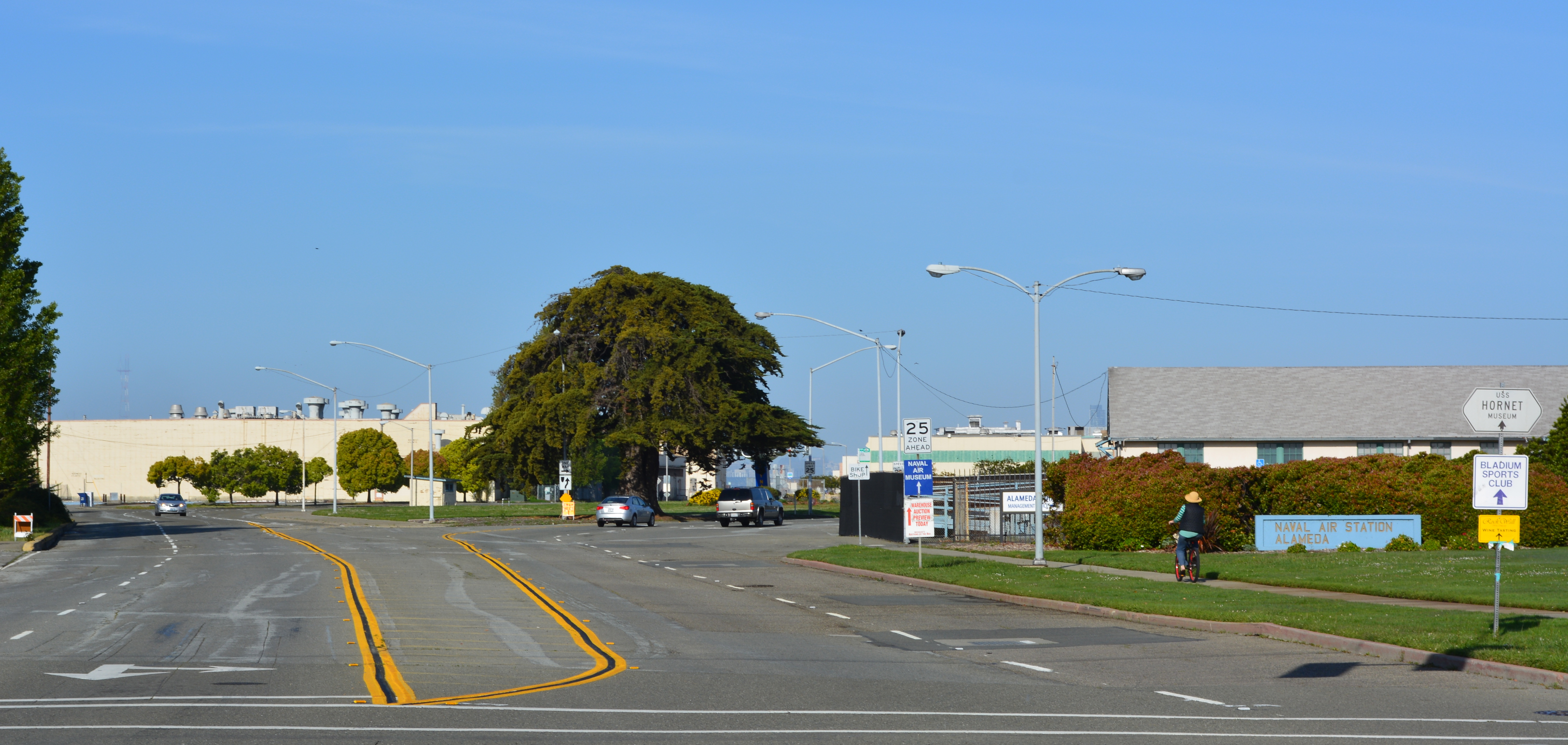
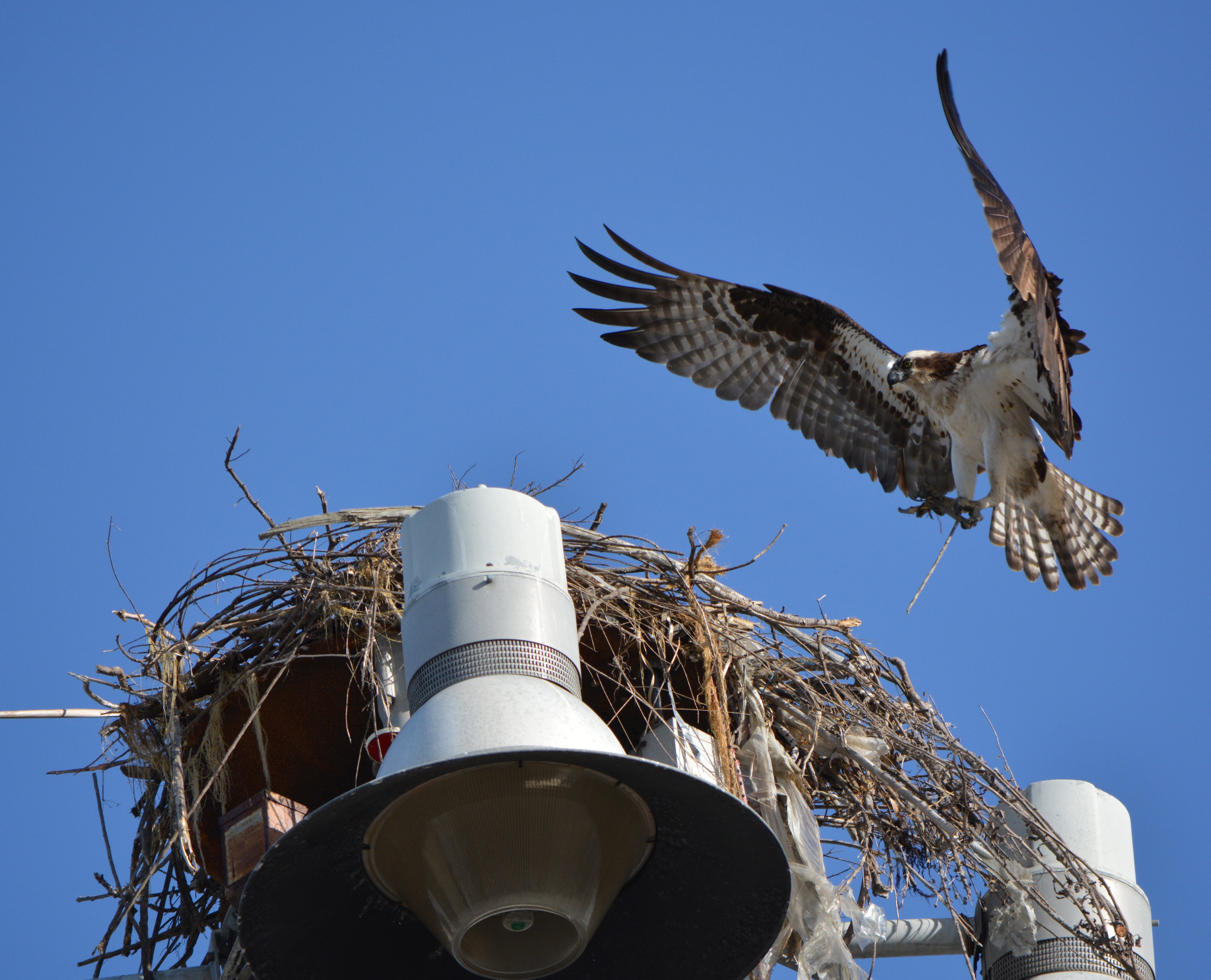
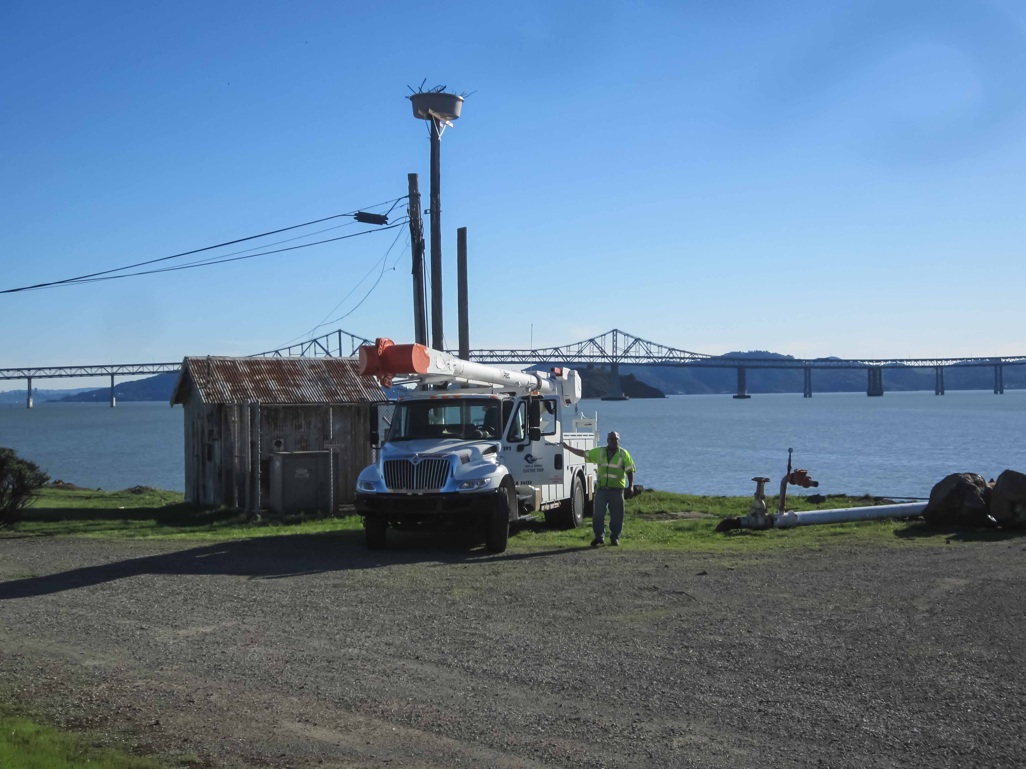
In early June a pair of returning ospreys looked ready for the day in their newly made nest atop a parking lot light pole at Alameda Point, but they had no chicks to attend to. The pair’s first nest this season — on a nearby ship — had been removed during construction.  Their second attempt faced interference from another osprey.  By June, hopes for fledglings this year had faded.  An ad hoc group of osprey watchers is hoping a dedicated osprey platform can be erected at Alameda Point in a spot where competing interests and annoyances of daily commotion don’t intrude into the reproductive efforts of the ospreys.

Male osprey bringing nesting material to light pole near maritime ships at Alameda Point with female looking on.

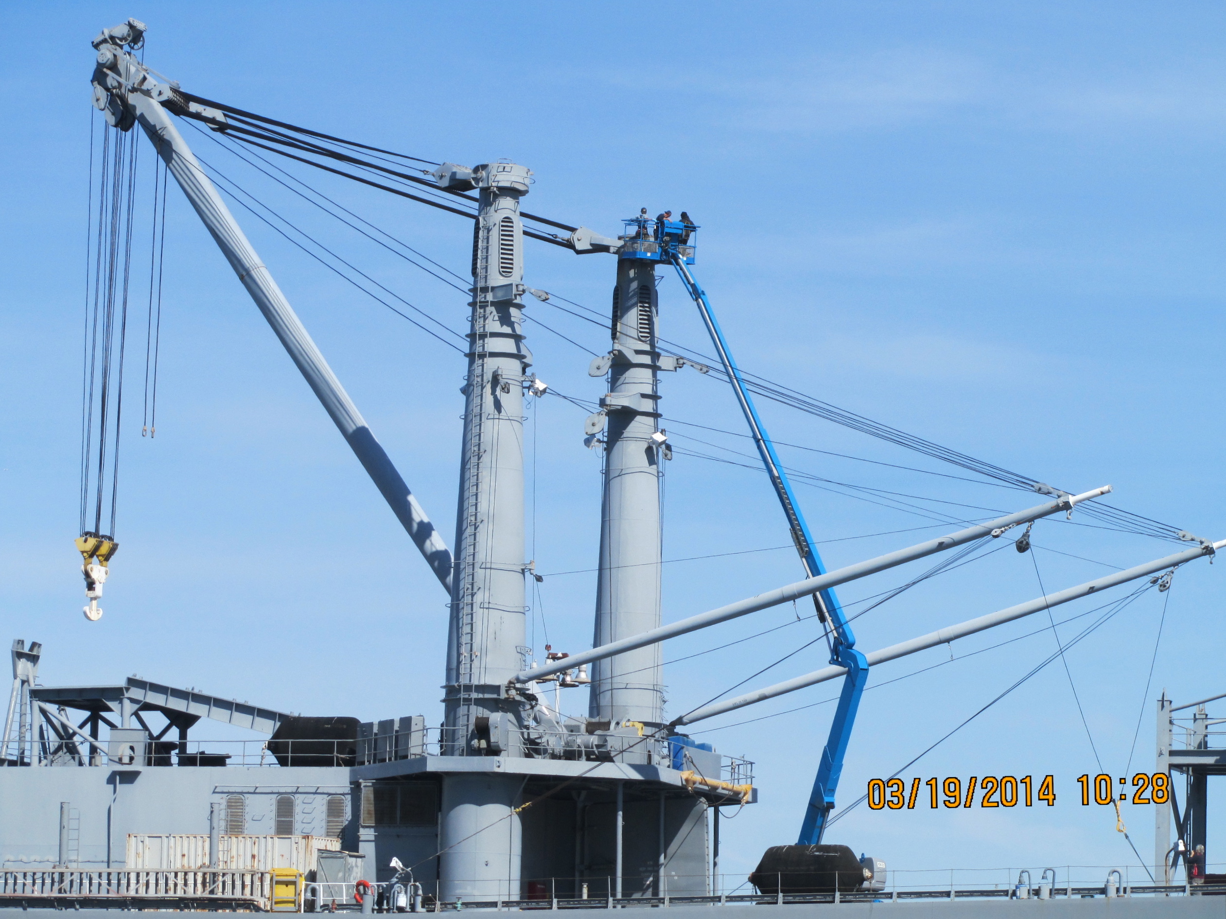
In early March the osprey pair began building their first nest this year where they had nested last year — on a kingpost high atop the maritime ship Admiral Callaghan. The ship’s owner, the Maritime Administration (MARAD), had removed last year’s nest. This year MARAD moved quickly to stop the nest building to avoid potential delay to relocate a nest if ordered into service. “The Maritime Administration worked closely with the California Department of Fish and Wildlife on dismantling the nest and installing deterrence devices on March 19 prior to any eggs being laid,” said Alameda resident Harvey Wilson, who has been monitoring the ospreys at Alameda Point.

Crew removing osprey nesting material from kingpost on Admiral Callaghan maritime ship at Alameda Point, March 2014.
Crew removing osprey nesting material from kingpost on Admiral Callaghan maritime ship at Alameda Point, March 2014.  Photo by Harvey Wilson.

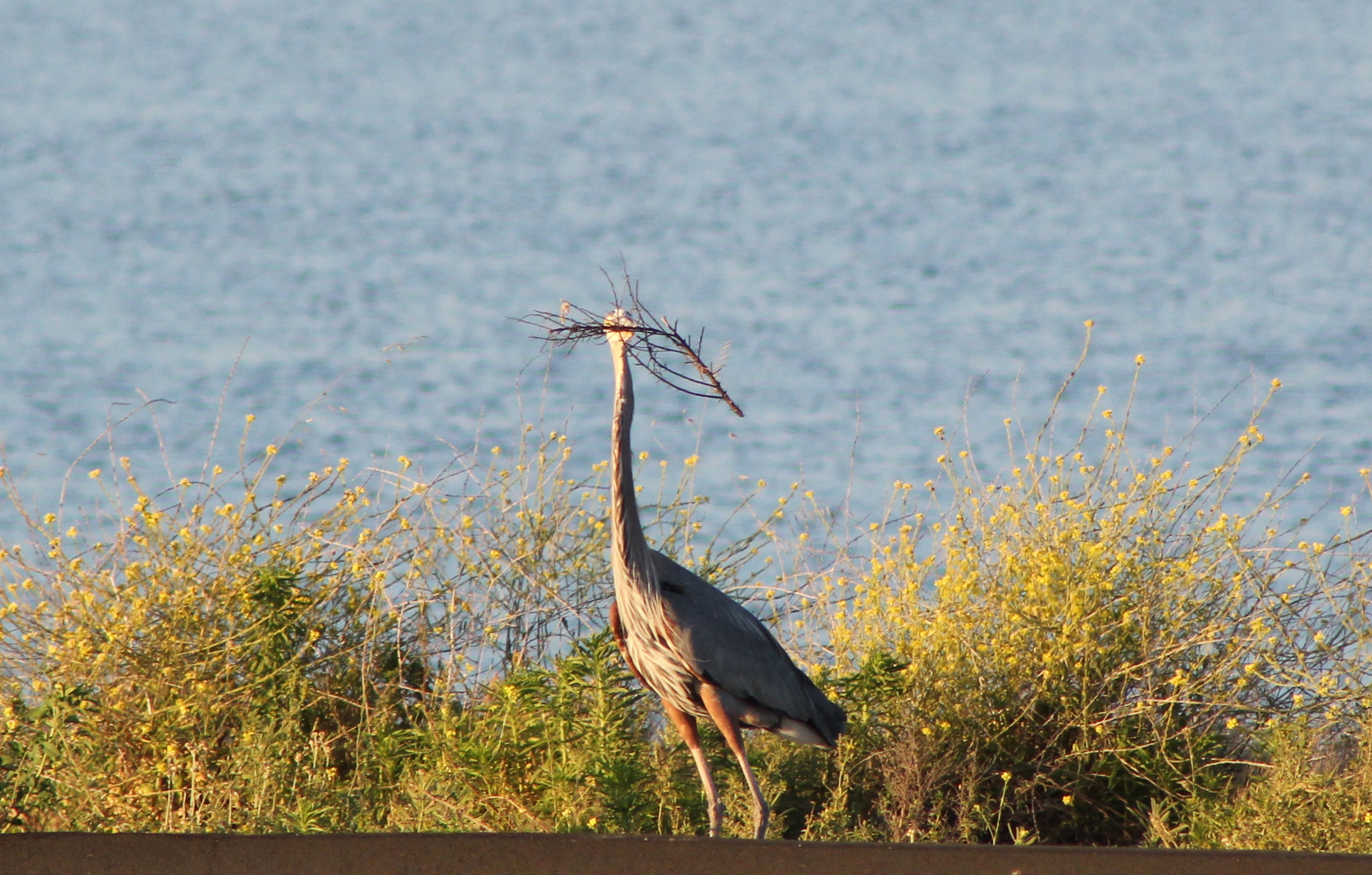
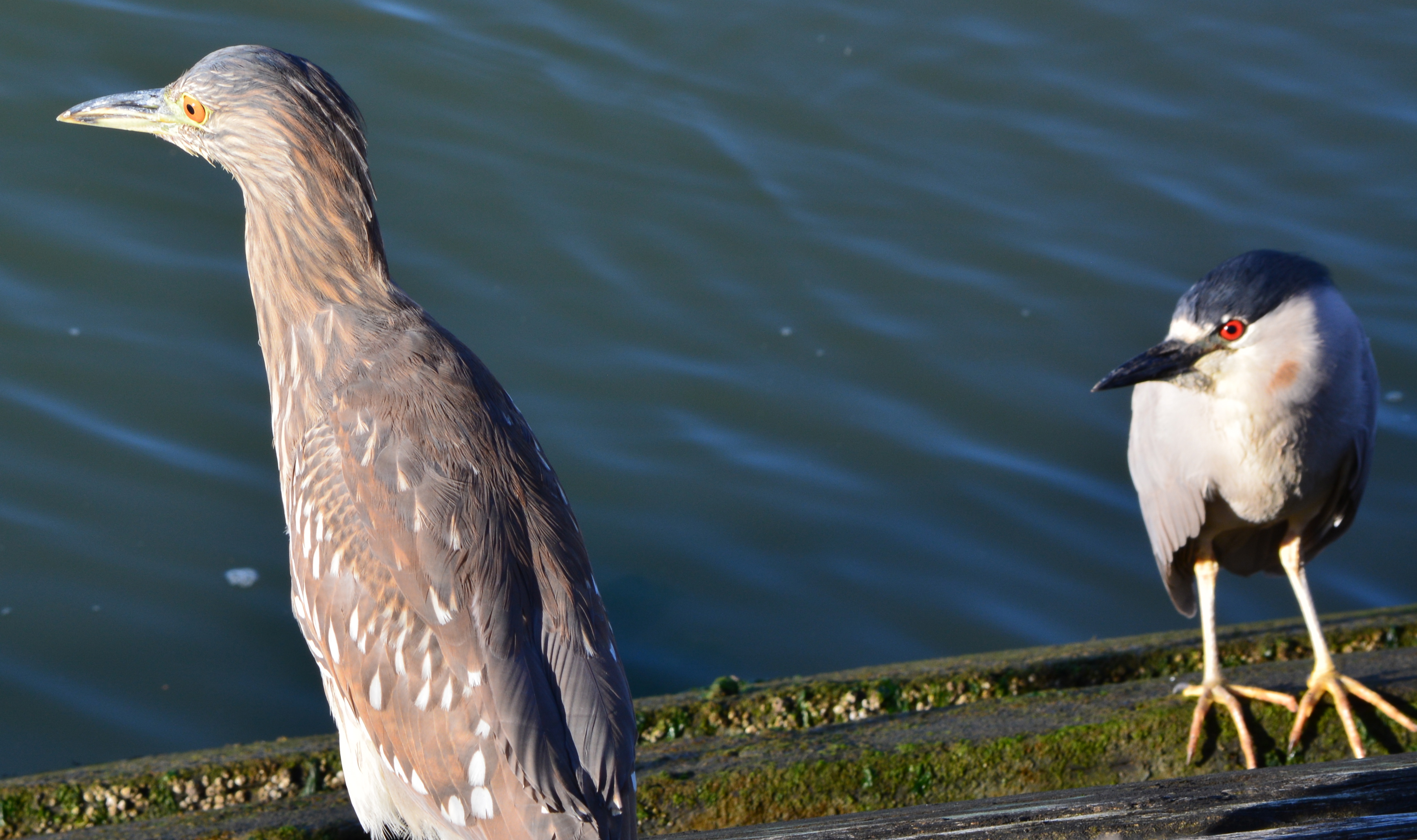
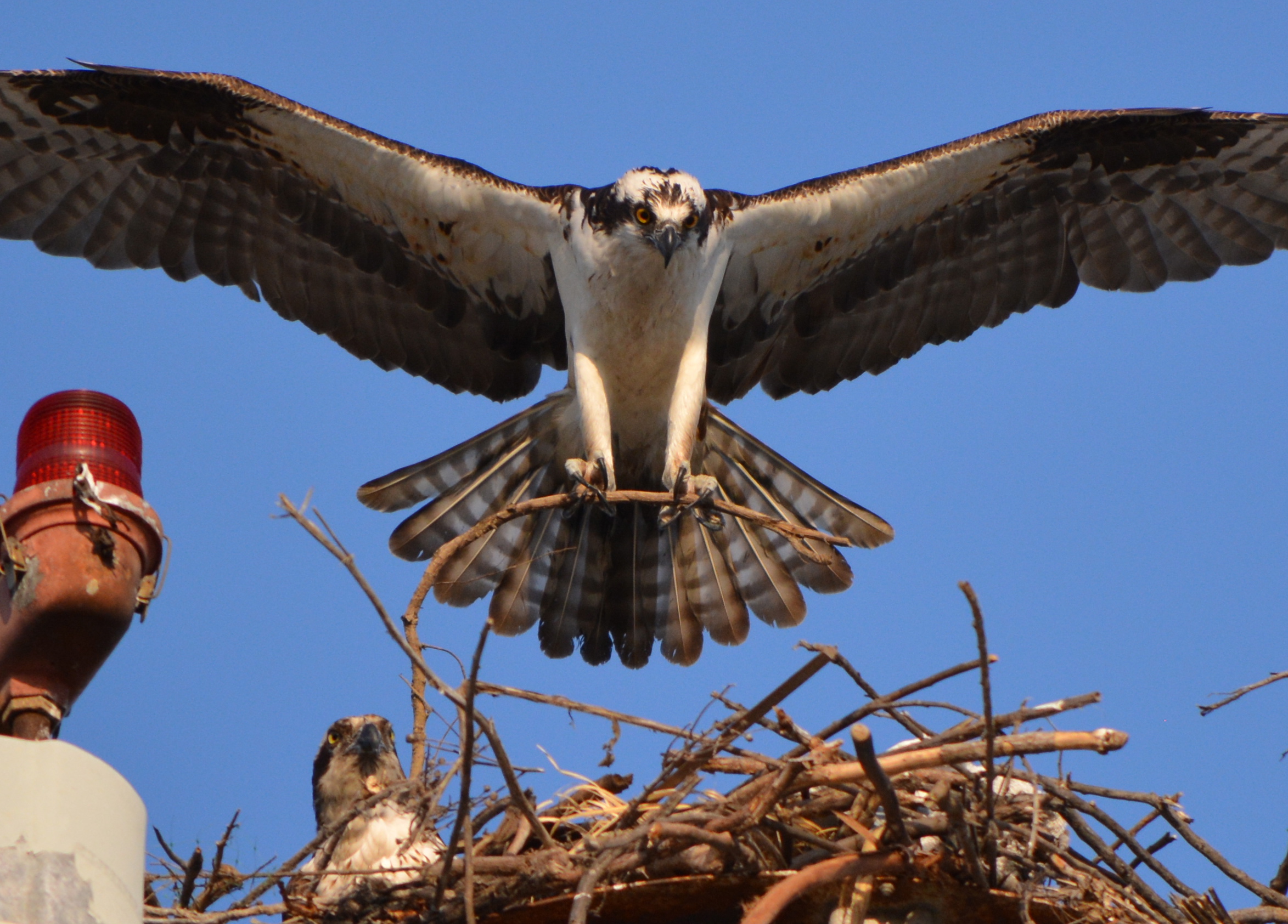
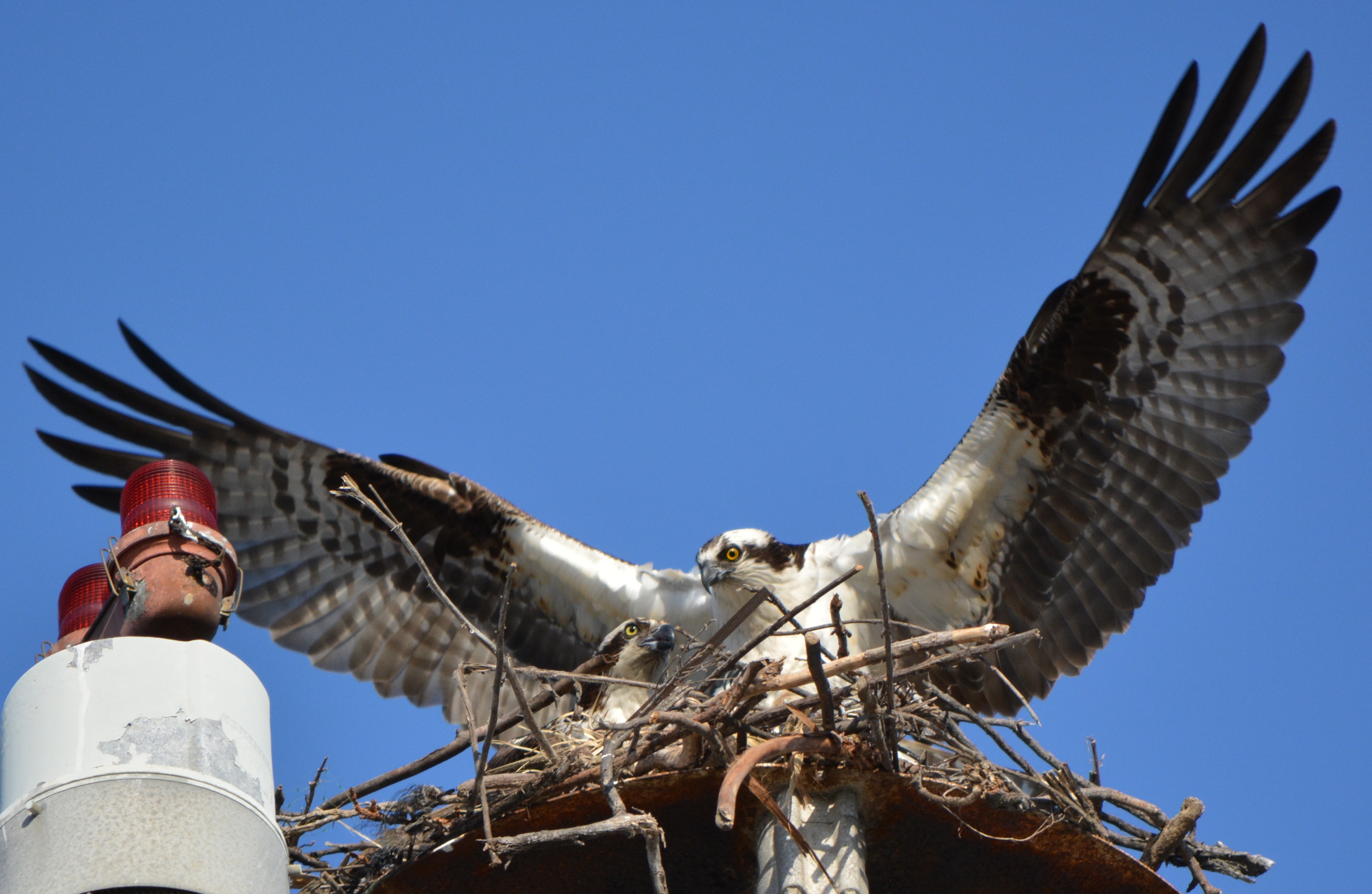
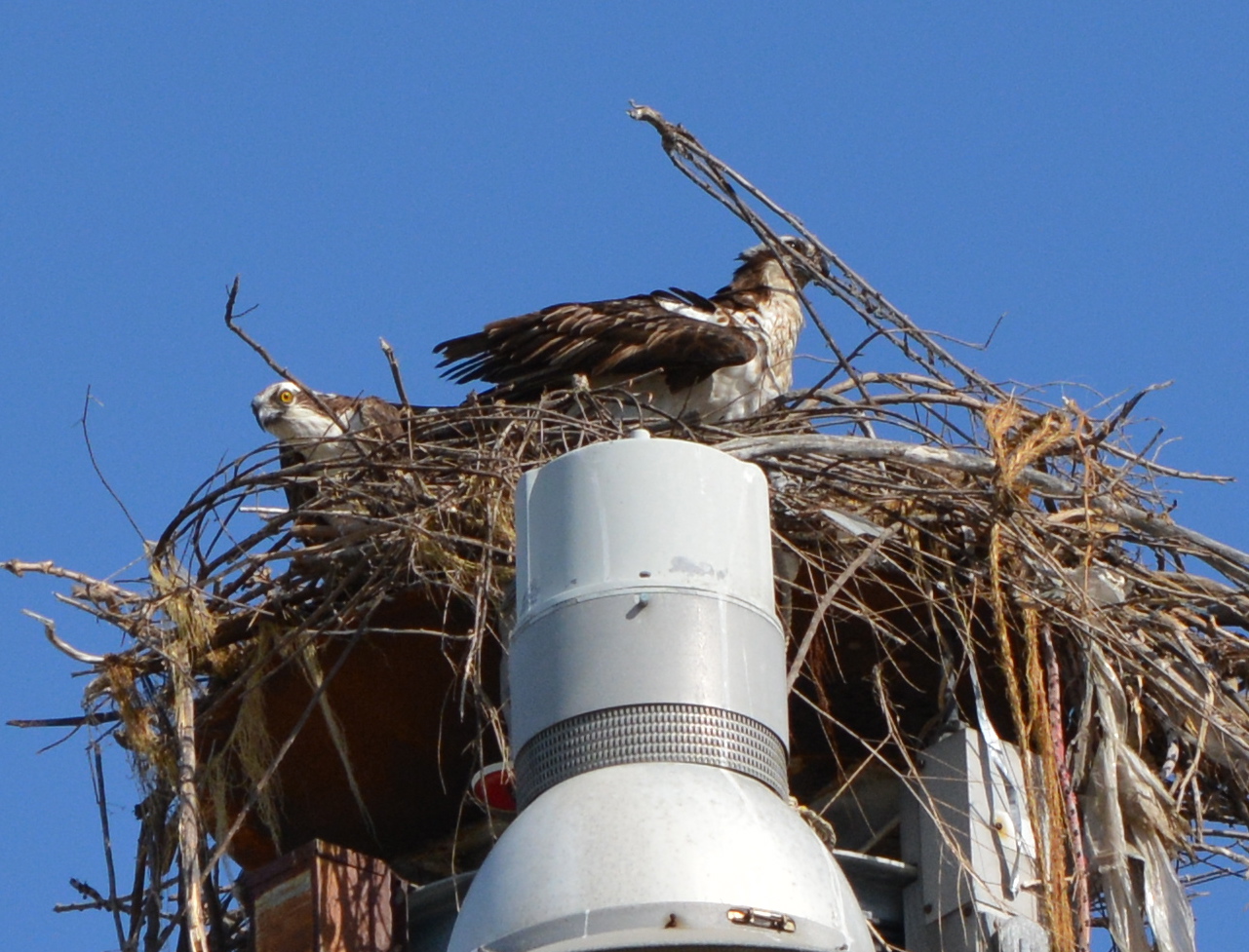
But that removal didn’t end the ospreys’ interest in the ship, at least not for the male osprey. He soon started bringing sticks to a lower-level hoisting post on the ship. The female, on the other hand, took a liking to a light pole in the parking lot next to the wharf. After weeks of back and forth episodes of mating and nest building at both sites, the female won, and nest building started ramping up on the light pole. At one point, it appeared that the female was hunkering down in the nest, a sign that eggs had been laid and incubation had started. But soon another female osprey appeared, trying to lure the male from his duties and disturbing the composure of the female.  

Female osprey bringing nesting material to nest on parking lot light pole near maritime ships at Alameda Point - May 2014.
Female osprey bringing nesting material to nest on parking lot light pole near maritime ships at Alameda Point – May 2014.

The third osprey now seems to have moved on, and the original pair has continued to visit the nest, but the lateness of the season offers little hope that eggs will be laid again, if they ever were, this year.

Osprey with striped bass in early June 2014 near maritime ships at Alameda Point.

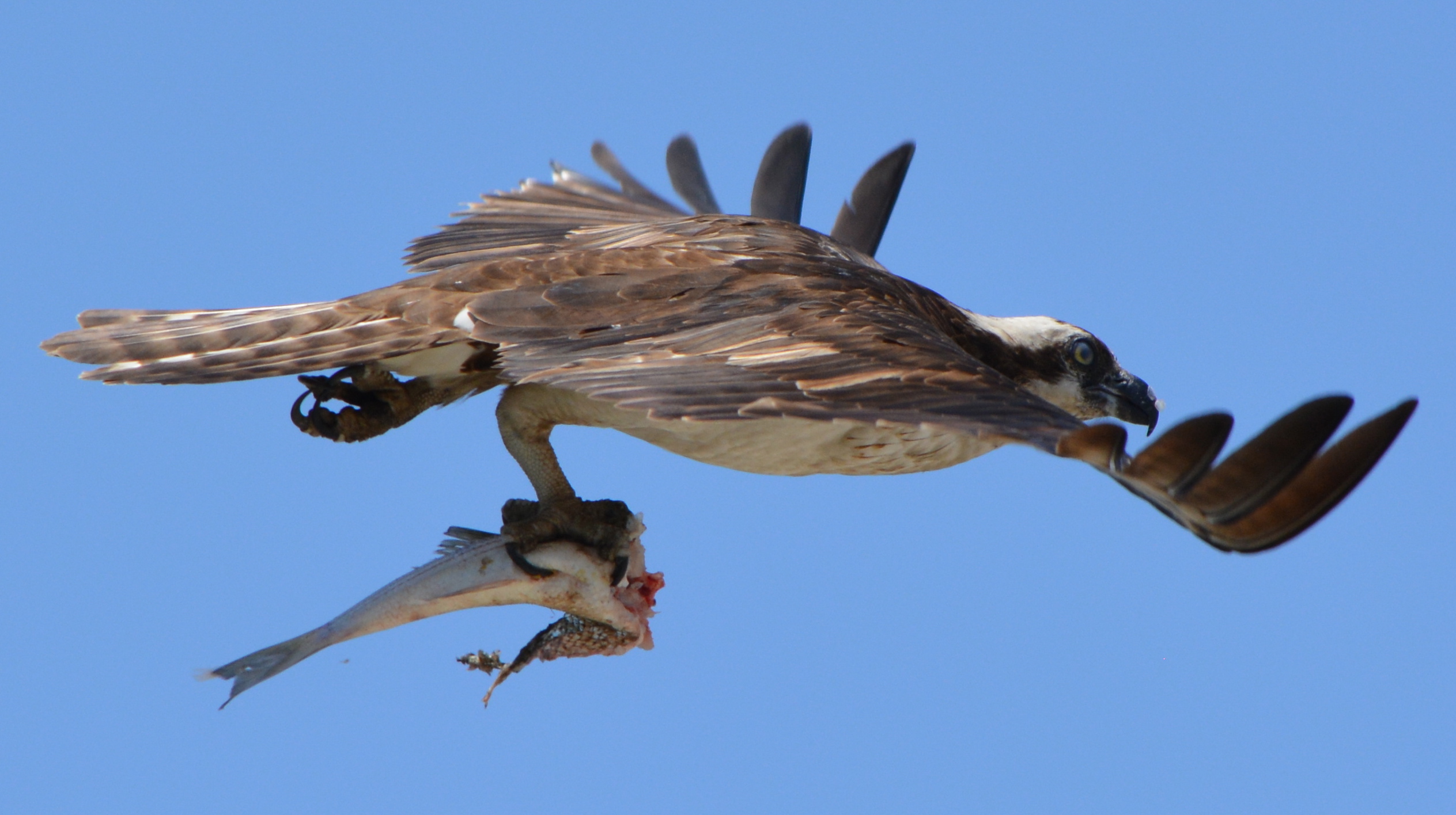
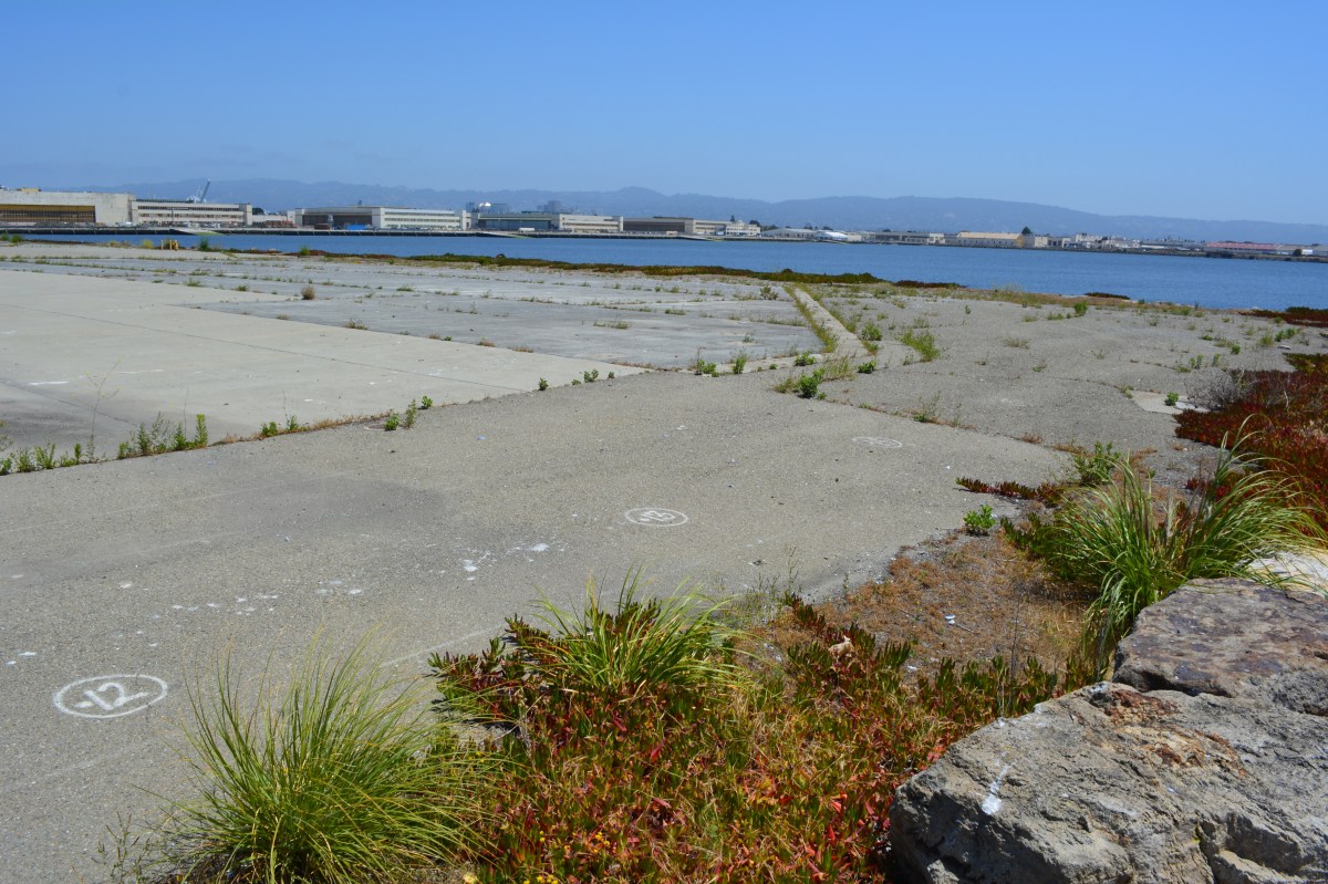
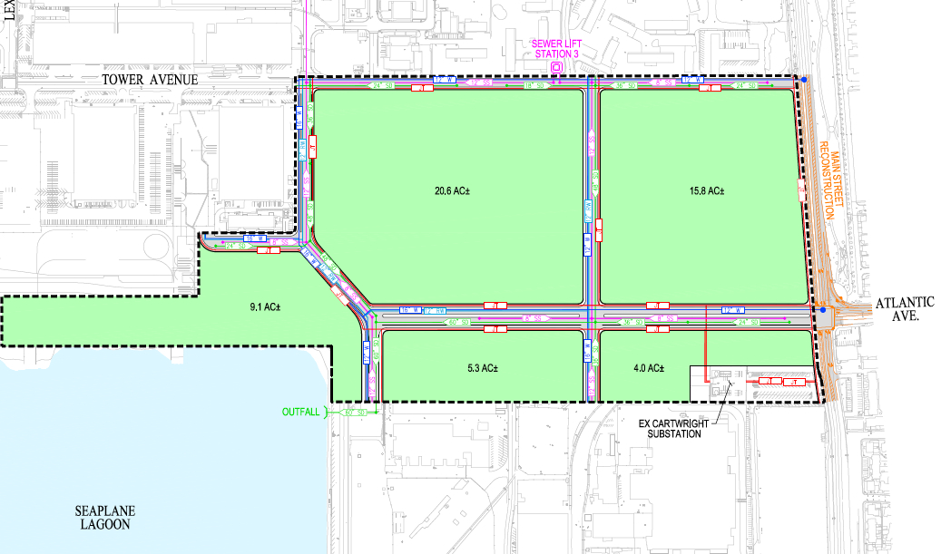
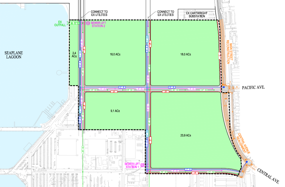
The appearance of ospreys at Alameda Point, first documented in 2010, is part of larger Bay Area phenomenon of ospreys beginning to nest on the shores of San Francisco Bay. Osprey first began nesting in the San Francisco Bay Area in the year 2000, having moved their nesting range further south. There are currently 24 active nests on San Francisco Bay. One theory for the ospreys’ Bayside nesting interest is a reduction of silt in the Bay, making it easier for osprey to catch fish, their primary food source. The high silt levels are a legacy of the gold mining era during which streambeds emptying into the Sacramento River were blasted with water canons to expose gold particles. Ospreys normally return to the same nest every year, but the Alameda Point pair has now used three different sites. In 2012 they successfully raised their lone chick on an old light stand on the western jetty of the Seaplane Lagoon, their regular nest for three years.   For unknown reasons, they chose the heights of a maritime ship in 2013, and in 2014 a parking lot light pole.

Osprey pair on their light pole nest April 18, 2014 as nest building continued.

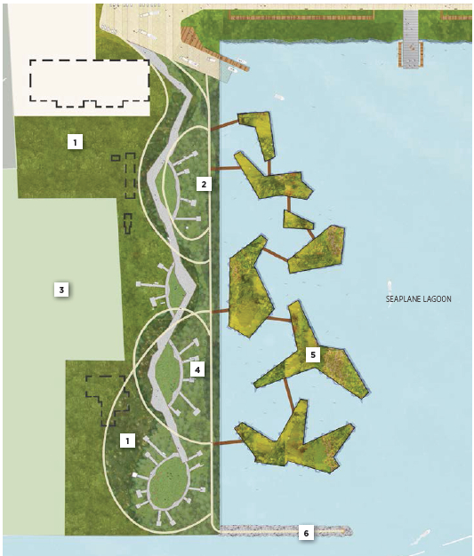
An ad hoc group of osprey watchers that includes members of the Golden Gate Audubon Society have been discussing with the city the possibility of erecting a permanent osprey nesting platform on the western side of the Seaplane Lagoon. “City staff has been and is willing to continue to work with interested members of the local community to potentially establish an osprey platform at Alameda Point,” said Jennifer Ott, Chief Operating Officer for Alameda Point.  “The identification of an appropriate location for this platform will depend on a number of factors, including approval by the United States Fish and Wildlife Service.” In March of this year, the city of Richmond’s Public Works Department assisted with the installation of an osprey platform at Pt. Molate, which helped divert nesting efforts from a utility pole with live wires. PG&E, with extensive raptor nesting diversion experience throughout California, has offered to install a pole and nesting tub at Alameda Point for free.

City of Richmond public works employee after installation of nesting tub at Pt. Molate.
City of Richmond public works employee after installation of nesting tub at Pt. Molate – March 2014.  This photo and three below are by Tony Brake.

“It is difficult to know what the ospreys feel or how they respond or what their capacity is for all the activity that goes on around them, but this season certainly challenged them,” said Alameda wildlife biologist Leora Feeney.  “Providing safe platforms for them out of busy corridors would serve everyone better.”

Female osprey arranging nesting material with male looking on.

Published on the Golden Gate Audubon Society’s blog Golden Gate Birder.

See also:

Shoreline grassland, wetland: An opportunity now at Alameda Point

The city’s west side of the Seaplane Lagoon at Alameda Point is mostly pavement – acres of it – with a few old buildings abutting a wetland on the federal property. The city claims its long-range plan for this area features a conversion to a wetland habitat, but their only commitment is to continue leasing the buildings to generate revenue while allowing a sea of unnecessary pavement to remain as an environmental blight.

Seaplane Lagoon west side, looking south.  Seaplane Lagoon on left, Alameda Point Channel and SF Bay in background.
Seaplane Lagoon west side, looking south. Seaplane Lagoon on left, Alameda Point Channel and SF Bay in background.  Temporary fence to be removed by end of 2014.

Opportunities for implementing ecosystem enhancement, both short and long term, have yet to be explored for this area. We need to start moving in a direction now that benefits the environment by reducing climate impacts, improves the atmosphere around nearby businesses, adds to public enjoyment, and increases wildlife habitat.

Proposal for ecosystem enhancement

Short-term plan – Remove all pavement not required for commercial tenants. Recycle the pavement at the VA’s Alameda Point project site where they will be raising elevation and need base rock and fill. Once the pavement is removed and the soil exposed, native vegetation could be planted. Native vegetation will absorb CO2, produce oxygen, eliminate the heat island effect of the former pavement, add wildlife habitat, improve the aesthetic appearance of the property, and make it attractive as a hiking, jogging, and cycling destination.

          Step 1 – Set aside money from lease revenue generated on the west side of the Seaplane Lagoon for pavement removal and introduction of native plant vegetation.

          Step 2 – Explore recycling pavement at Alameda Point.

          Step 3 – Explore grant sources for conversion of paved areas to native vegetation, i.e., state air quality board, EPA, State Lands Commission, etc.

West side of Seaplane Lagoon, looking north.  Seaplane Lagoon on right.  Buildings 29 and 25 on left.  Most of this area could be covered with native grasses with no negative effects on commercial leasing.
West side of Seaplane Lagoon, looking north. Seaplane Lagoon on right. Buildings 29 and 25 on left. Most of this area could be covered with native grasses with no negative effects on commercial leasing.

Long-term plan – Establish an Alameda Point Wetland Mitigation Bank, which would incorporate the west Seaplane Lagoon acreage along with 50 acres on the northwest side of Alameda Point (Northwest Territories). Investment money would provide the capital for wetland creation, with money being recouped when mitigation credits are sold to developers elsewhere in the Bay watershed to offset their project’s impacts. As a general rule, a tidal wetland is worth at least as much as it would cost to create it. That’s why businesses exist that specialize in mitigation banks. In theory at least, the wetland project could be self-funding.

          Step 1 – Commission a study on wetland mitigation bank formation using lease revenue from Buildings 25 and 29.

Information about wetland mitigation banking:

Report To The Legislature – California Wetland Mitigation Banking – Jan. 2012 

U.S. Wetland Banking – Market Features and Rules

Forbes wetland article 4/25/2014 from BCDC

West side of Seaplane Lagoon looking south, with channel and Breakwater Island in background.
West side of Seaplane Lagoon, looking northeast from shoreline riprap, with lagoon and hangars in background.
West side of Seaplane Lagoon, looking northeast from shoreline riprap, with lagoon and hangars in background.  Pavement here will serve no commercial purpose under current low-impact guidelines.
Great Blue Heron gathering nesting material on western edge of Seaplane Lagoon for nearby nest.  Increased vegetation will bring more birds along shoreline.
Great Blue Heron gathering nesting material on western edge of Seaplane Lagoon for nearby nest. Increased vegetation will bring more birds along shoreline.
CA Least Terns engaged in courtship ritual of exchanging a fish on jetty adjacent to west side of Seaplane Lagoon - May 2014.
CA Least Terns (center of photo) engaged in courtship ritual of exchanging a fish on jetty adjacent to west side of Seaplane Lagoon – May 2014.
Barn Swallow on fence on west side of Seaplane Lagoon.  Common to the area, often seen flying low over the water looking for flying insects,  nesting almost exclusively on man-made structures, possibly Building 29.
Barn Swallow on fence on west side of Seaplane Lagoon. Common to the area, often seen flying low over the water looking for flying insects, nesting almost exclusively on man-made structures, possibly Building 29.
Breakwater Island viewed from shoreline on west side of Seaplane Lagoon.  Breakwater Island is a roosting site for CA Brown Pelicans and other birds.  Island owned by city of Alameda.
Breakwater Island viewed from shoreline on west side of Seaplane Lagoon. Breakwater Island is a roosting site for CA Brown Pelicans and other birds. Island owned by city of Alameda.
Landscape plan from 2013 showing no buildings on west (left) side of Seaplane Lagoon.  Buildings are now being recommended to stay.  Floating wetlands are a very long-range option if funding is available.
Landscape plan from 2013 showing no buildings on west (left) side of Seaplane Lagoon. Buildings are now being recommended to stay. Floating wetlands are a very long-range option if funding is available.
2014 plans for west side of Seaplane Lagoon show buildings in dashed lines.  Active leasing of buildings currently underway suggests buildings should be in solid lines and wetland in gray.
2014 plans for west side of Seaplane Lagoon show buildings in dashed lines. Active leasing of buildings currently underway suggests buildings should be in solid lines and wetland in gray.
Looking west from west side of Seaplane Lagoon.  Bay/Channel on left.  Building 29 on right.  City property extends beyond fence to far edge of Building 29 property line.
Looking west from west side of Seaplane Lagoon. Bay/Channel on left. Building 29 on right. City property extends beyond fence to far edge of Building 29 property line.
Runway Wetland area on federal property adjacent to Building s 25 and 29 on city property at west side of Seaplane Lagoon.  A naturalized west shoreline of Seaplane Lagoon, with public access, would enhance the greater wildlife habitat in this area.
Runway Wetland area on federal property adjacent to Buildings 25 and 29 on city property at west side of Seaplane Lagoon. A naturalized west shoreline of Seaplane Lagoon, with public access, would enhance the greater wildlife habitat in this area.

Take the plunge!  Remove pavement on the west side of the Seaplane Lagoon and improve our environment.

Gosling ready to plunge onto rocks below, on west side of Seaplane Lagoon, to get to parents in the Alameda Point Channel.
Gosling ready to plunge onto rocks below, on west side of Seaplane Lagoon, to get to parents in the Alameda Point Channel.  It was successful.

Black-crowned Night Heron Juvenile – Gallery and Video – Spring 2014

A Black-crowned Night Heron adult and its juvenile offspring were spotted along the south shoreline of Alameda Point during May and June of this year.  The juvenile was seen foraging for food on the shoreline, as well as using the old dock for a resting area.  Use of the old dock by a wide variety of birds, as well as a family of harbor seals, illustrates the habitat value of the waterfront and the wisdom of providing a new wildlife water platform when the Water Emergency Transit Authority removes the old dock for their new maintenance facility this year.

Black-crowned Night Heron juvenile and left and adult on right.  Perched on remnants of old Navy recreational dock in Alameda Point's Inner Harbor on south side.
Black-crowned Night Heron juvenile and left and adult on right. Perched on remnants of old Navy recreational dock in Alameda Point’s Inner Harbor on south side.
Black-crowned Night Heron juvenile foraging on Alameda Point shoreline.

Black-crowned Night Heron juvenile Alameda Point

Black-crowned Night Heron juvenile June 2014

Black-crowned Night Heron juvenile close-up

Black-crowned Nigh Heron juvenile hanging out on dock with other wildlife.
Shoreline area where Black-crowned Night Heron juvenile and adult were viewed next to old dock at blue arrow.
Shoreline area where Black-crowned Night Heron juvenile and adult were viewed next to old dock at blue arrow.  Part of old dock in image has sunk.

Groundwater solvent cleanup will use cheese whey and veggie oil to feed natural bacteria

Cleanup Operating Unit 2B at east entry to proposed Town Center - Alameda Point.    Graphics by Alameda Point Environmental Report.
Cleanup Operating Unit 2B at east entry to proposed Town Center – Alameda Point. Graphics by Alameda Point Environmental Report.

A Navy contractor will be cleaning up groundwater in part of the Town Center area next to the Seaplane Lagoon by injecting a solution of cheese whey, emulsified vegetable oil and water into nearly 200 wells that go down between 30 and 40 feet. The whey and vegetable oil will cause natural bacteria to flourish that will feed on the toxic trichloroethene (TCE) solvent causing it to break down.

According to the Navy, this type of food-stimulated bacterial bioremediation is common. The cheese whey is similar to the powdered whey products found in grocery stores. It will be delivered to the site already diluted in water. A hose will be connected to a fire hydrant and hooked to a metering device that will mix the whey and oil solution with municipal water as it is pumped into the wellheads.

The work is expected to begin in 2015, with periodic visits and testing until 2020. The first year of operation the contractor will make two visits of 35 days each. During each of these work periods they will inject 246,000 gallons of whey, oil, and water solution into the ground, allowing gravity to disperse the liquid.

The goal of the cleanup is to minimize the potential for hazardous vapors entering buildings, and chemicals migrating into the Seaplane Lagoon. TCE is an industrial solvent used to degrease metal parts. It was heavily used at aircraft and ship engine repair facilities on the site. A leak from a rail car is believed to be one of the major sources of the plume.

The 33-acre cleanup area is immediately to the south of the Navy jet on West Atlantic Avenue at the east entry to Alameda Point near Main Street. It is within the 150 acres of the Town Center that the city is seeking to develop in the near future.  In April, the city council sent out requests seeking qualified developers interested in residential and commercial projects. The cheese and veggie oil cleanup area will not be transferred to the city until at least 2020 when cleanup has been certified to have met its goals.

Cleanup of fuel in groundwater ended about four years ago at an old fuel distribution point on the north side of the jet monument.

Below is an audio and image presentation from the Alameda Point Restoration Advisory Board meeting on May 8, 2014.

voice graphic w:text

Slide01

Slide02

Slide03

Slide04

Slide05

Slide06

Slide07

Slide08

Slide09

Slide10

Slide11

Slide12

One of the high contamination "hot spots" that will get extra treatment to cleanup trichlorethene solvent in groundwater 30 to 40 feet deep.
One of the high contamination “hot spots” that will get extra treatment to cleanup trichloroethene solvent in groundwater 30 to 40 feet deep.
Fenced area is where testing was conducted.  This is one of the hot spot areas that will get extra attention to clean up trichloroethene in groundwater.
Fenced area is where testing was conducted. This is one of the hot spot areas that will get extra attention to clean up trichloroethene in groundwater.
Groundwater cleanup area on OU-2B.  Cleanup will not be completed until 2020.  Looking west with maritime ships in background in Seaplane Lagoon.
Groundwater cleanup area on OU-2B. Cleanup will not be completed until 2020. Looking west with maritime ships in background in Seaplane Lagoon.

Phony green shoreline park plans for Seaplane Lagoon at Alameda Point

The drawing and images for the so-called “De-Pave Park” on the western side of the Seaplane Lagoon would be something to cheer about if the park had any chance of ever being created. The text of the city’s recently released Town Center and Waterfront Plan, however, allows existing industrial buildings along the western edge of De-Pave Park to remain “if needed.”

Proposed De-Pave Park location w:buildings

Such a caveat sets the framework for never moving forward with the plans. If the buildings are being leased, the buildings will be “needed.” If the buildings are needed, then the pavement around them will also be needed. The city is continuing to market these buildings to tenants and, thus, there’s not likely to come a day when we try to secure grant money to develop the park.

Building 29 blight

This is a change from the first presentation of De-Pave Park in 2013 when the Town Center and Waterfront Plan was rolled out. The existing structures were not shown in that drawing.  The community was led to believe that all structures would be removed to provide a natural wetland-oriented transition to the existing Runway Wetland on federal property. Not so anymore. The structures can stay.

Conceptual plan presented in 2013 did not indicate that any buildings would remain between De-Pave Park and the Runway Wetland on the federal property.
2014 De-Pave Park plan shows dashed lines indicating existing structures that will be allowed to remain "if needed."
2014 De-Pave Park plan shows dashed lines indicating existing structures that will be allowed to remain “if needed.”  Floating wetlands do not exist right now, and probably never will.

The infrastructure plan now has a levee protecting the 55-foot tall “Building 25” from sea level rise. There would be no reason to protect this eyesore if it was slated for permanent removal. Furthermore, the building is part of the mixed-use commercial and residential waterfront zone where even a hotel is permitted.

55-foot tall "Building 25" that will be protected by a levee, and remind campers that they are on an old military industrial site, as they gaze at the night stars.
55-foot tall “Building 25” that will be protected by a levee, and remind campers that they are on an old military industrial site, as they gaze at the night stars.

The plan’s conceptual drawing and photo collage showing campers, hikers, and grasslands does not include a view to the west, and with good reason.  It would show the industrial legacy that will interrupt the potentially expansive views toward the west. It’s deceptive advertising.

Looking toward the Seaplane Lagoon in conceptual drawing for De-Pave Park.  No drawings are offered to inform viewers that directly behind this vantage point are old industrial buildings that will be allowed to stay "if needed."  There is currently no plan to remove the industrial buildings.
Looking toward the Seaplane Lagoon in conceptual drawing for De-Pave Park. No drawings are offered to inform viewers that directly behind this vantage point are old industrial buildings that will be allowed to stay “if needed.” There is currently no plan to remove the industrial buildings.

Parks, as we’ve learned during the new zoning designations for Alameda Point, are zoned Open Space. This “park” is not zoned Open Space. It’s another indication that the so-called “De-Pave Park” is phony.

Changing the western shoreline of the Seaplane Lagoon to a wetland-grassland landscape connected to the Runway Wetland would implement climate change adaptation goals and carbon sequestration goals. Without a commitment by the city to implement De-Pave Park in the Town Center and Waterfront Plan – including removal of all buildings on the western side of the Seaplane Lagoon – a great opportunity to help rebalance the San Francisco Bay ecosystem will fall through the loopholes.

City Hall is requesting comments on the draft plans for the Town Center and Waterfront Plan by May 15, in preparation for a June 9 Planning Board meeting. The plan will be the guiding document on how, where, and what gets built around the Seaplane Lagoon. The city council is expected to approve the plan in July. Comments can be submitted to city planner Andrew Thomas at athomas@alamedaca.gov for forwarding to the Planning Board.

Red line indicates levee that will protect "Building 25."
Red line indicates levee that will protect “Building 25.”
Western side of the Seaplane Lagoon with potential for a major rebalancing of the Bay ecosystem.
Western side of the Seaplane Lagoon with potential for major improvements to the Bay ecosystem.
Seaplane Lagoon looking west, with blighted viewscape that will allowed to remain.  San Francisco is in background.  "Building 25" is the large building on the right that will be saved by a levee.
Seaplane Lagoon looking west, with blighted viewscape that will be allowed to remain. San Francisco is in background. “Building 25” is the large building on the right that will be saved by a levee.


Reference:  Open Space, Landscape, and Sustainability sectionDraft Town Center and Waterfront Precise Plan for Alameda Point.

Least tern nesting area refurbished and ready for 2014 at Alameda Point

The 9.7-acre nesting area for the endangered California least terns at Alameda Point received a new layer of sand this year. Sixty dump truck loads of sand were delivered to the site on the old Navy airfield in March, paid for by the U.S. Fish & Wildlife Service (USFWS).

Fresh layer of sand on Alameda Point least tern nesting site.  Looking south, with ships in San Francisco Bay in background.
Fresh layer of sand on Alameda Point least tern nesting site. Looking south, with ships in San Francisco Bay in background.

After the sand was moved into place, USFWS and volunteers set up a numbered cinderblock grid system used for recording behavior and also distributed chick shelters and oyster shells for the chicks to use as protection from the elements and predators.

On Sunday, April 13 a dozen volunteers showed up for the last work party prior to nesting. The task of the day was distributing oyster shells around the site, which provide a nominal amount of sun protection for chicks and, in theory, helps make it more difficult for avian predators like red-tailed hawks and peregrine falcons to spot the chicks amongst all the white shells.

Distributing oyster shells at tern colony

From now until the end of the nesting season in mid-August, volunteers will be participating in another program called the Tern Watch Program. Participants monitor behavior and watch for predators from their vehicles outside the nesting area.

Throughout the nesting season a USFWS biologist makes periodic walks through the site and places numbered plaster markers next to nests so that the number of eggs and success rates can be accurately recorded. If there are three eggs in a nest one week, for example, and one egg the next week with no chicks, it’s an indication that predators have grabbed the eggs.

Each year following the end of the nesting season in August, volunteers at monthly work parties gather up the oyster shells, the wooden A-frames, drain tiles, grid markers, and the hundreds of numbered markers used to identify nests. Clearing the site makes it easier to remove weeds and grade the sand, which can erode during rains. The volunteers pull weeds from inside and around the perimeter of the fenced-in site. The volunteer program during the non-nesting season is organized by the Golden Gate Audubon Society’s Friends of the Alameda Wildlife Reserve committee, in conjunction with the USFWS biologist in charge of the Alameda Point tern colony.

The effort to protect the least terns was begun by the Navy when nesting activities were first noticed in the 1980s. The likely reason for the terns choosing such an unlikely place to nest was the absence of people who might trample on the nests. The nesting site was chosen by the terns, not by the Navy or USFWS, and has been expanded to its current size as the colony expanded. The sandy substrate that approximates the traditional beach nesting habitat for terns is on top of old airfield pavement. Due to erosion caused by wind and rain, the sand has to be periodically replaced, as it was in 2009 and 2011.

Training sessions for this year’s Tern Watch Program will be held at the USFWS office at Alameda Point on April 26, April 30, May 28, and May 31. Volunteers do not have to be a bird expert, just be very interested in observing and reporting about them. Participants are required to attend one training session and commit to signing up for a minimum of three of the 3-hour shifts. Also required are binoculars, cell phone, and personal vehicle. Reservations for the training sessions can be made by calling Susan Euing at 510 521-9717 or by emailing susan_euing@yahoo.com. Directions and registration materials will be sent by email.

The annual Return of the Terns bus tour to the nesting area will be held on June 14 this year. The tour departs from the Crab Cove Visitor Center in Alameda. Registration required through the East Bay Regional Park District’s website or at the visitor center.

Reprinted on the Golden Gate Audubon Society’s Golden Gate Birder blog.

Adult least tern with chicks next to oyster shells at Alameda Point, June 15, 2013, during the Return of the Terns tour.  Plaster marker with number on reverse side is to the right.
Adult least tern with chicks next to oyster shells at Alameda Point, June 15, 2013, during the Return of the Terns tour. Plaster marker with number on reverse side is to the right.
April 13, 2014 work party, with Port of Oakland in background.
April 13, 2014 work party, looking north, with Port of Oakland in background.
Killdeer sitting on four eggs in the least tern nesting area on April 13, 2014.  It is not uncommon for a few killdeer to nest among the terns.  Killdeer lay their eggs about a month before the terns lay eggs.
Killdeer sitting on four eggs in the least tern nesting area on April 13, 2014. It is not uncommon for a few killdeer to nest among the terns. Killdeer lay their eggs about a month before the terns lay eggs.

Developers being sought for 150-acre gateway to Alameda Point

The city council will consider a staff proposal on April 15 to begin a major construction effort at the eastern entryway to Alameda Point, formerly known as the East Gate. The proposal seeks approval to solicit qualified developers for two parcels totaling 150 acres that would bring 800 new homes and a major sales tax generator.

West Atlantic Avenue on Alameda Point, looking west toward San Francisco.

The quest for developers is being proposed “in order to facilitate new residential and commercial mixed-use projects that are of a sufficient scale to support major infrastructure investment,” said Jennifer Ott, Chief Operating Officer for Alameda Point. “It will create a catalyst for additional new development and investment elsewhere” at Alameda Point.

The proposal seeks a single developer for an entire 68-acre parcel, dubbed Site A, which extends along West Atlantic Avenue from Main Street to the Seaplane Lagoon. It would feature a mixed-use, 800-home development that is consistent with the recently approved Town Center Waterfront Plan. The plan requires ground-floor retail along certain blocks and public plazas and amenities at the heart of the area.  Hotels and office development will also be highly encouraged.

Site B is composed of 82 acres in southeastern Alameda Point. Part of the site is within the commercial Enterprise Zone and part is within the Town Center Waterfront Plan area. Unlike Site A, the proposal for Site B will entertain multiple developers. “This approach allows the city to potentially attract interest from a large corporate user or retail outlet operator, who may not be interested in the entire area,” says the staff report. Preference will be given to developers who furnish letters of interest from a corporate user or retail outlet operator.

Area A, Area B - development areas

The staff report notes that significant early phases of development can commence around a 33-acre area that is undergoing environmental cleanup by the Navy. The groundwater cleanup area is not scheduled for transfer to the city until 2020. One of the early defining phases of development will be the realignment of West Atlantic Avenue so that Ralph Appezzato Parkway continues in a straight line to Ferry Point Road.

The staff proposal outlines an aggressive schedule, which calls for bringing a short list of developer candidates to the city council by September. In November, the council will be asked to approve exclusive negotiating agreements with developers. By the spring of 2015, the staff hopes to produce development contracts and development plans, with developers beginning their detailed site-specific infrastructure designs. By the end of 2015, the schedule calls for beginning infrastructure construction and drafting the building designs, according to Ott. By the spring and summer of 2016, the city hopes to see vertical construction.

West Atlantic Avenue Gateway to Alameda Point.  Area B begins at far side of lawn area where all new construction is proposed.   Looking south.
West Atlantic Avenue Gateway to Alameda Point. Area B begins at far side of lawn area where all new construction is proposed. Looking south.

Developers will be required to submit a project description, but will be expressly prohibited from submitting site plans or any design renderings of any proposed development. “The selection of the developers/users will be solely based on the qualifications of the developers/users and the quality of their submittal, including past projects, not on the quality of any design drawings purporting to show the future of Alameda Point,” says the staff report. “Submission of a site plan or renderings at this stage of the process will result in disqualification of the responding entity.”

“City staff also receives significant interest in, and is actively pursuing, other long-term investment opportunities, such as the recently approved Google lease, in the other areas of the base, especially in the Historic District,” said Ott.

Current plans call for 1,425 housing units at complete build-out of Alameda Point, 25% of which are required to be affordable.

The Tuesday, April 15 city council meeting will be held at 7 PM at City Hall, 2263 Santa Clara Avenue, Council Chambers, 3rd Floor.  

The city staff report and agenda exhibits can be found here.

Proposed development areas A and B outlined on Navy land conveyance schedule map.
Area A new street grid.  See legend below.  Click on image to enlarge.
Area A new street grid. See legend below. Click on image to enlarge.
Proposed development Area B street grid.  See legend below.
Proposed development Area B street grid. See legend below.
Infrastructure legend for Areas A and B.