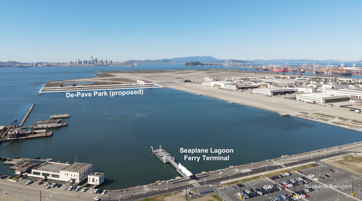
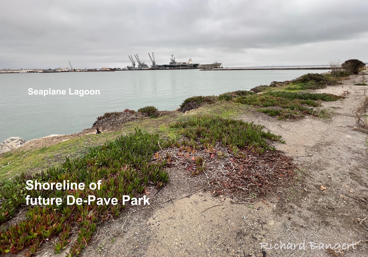
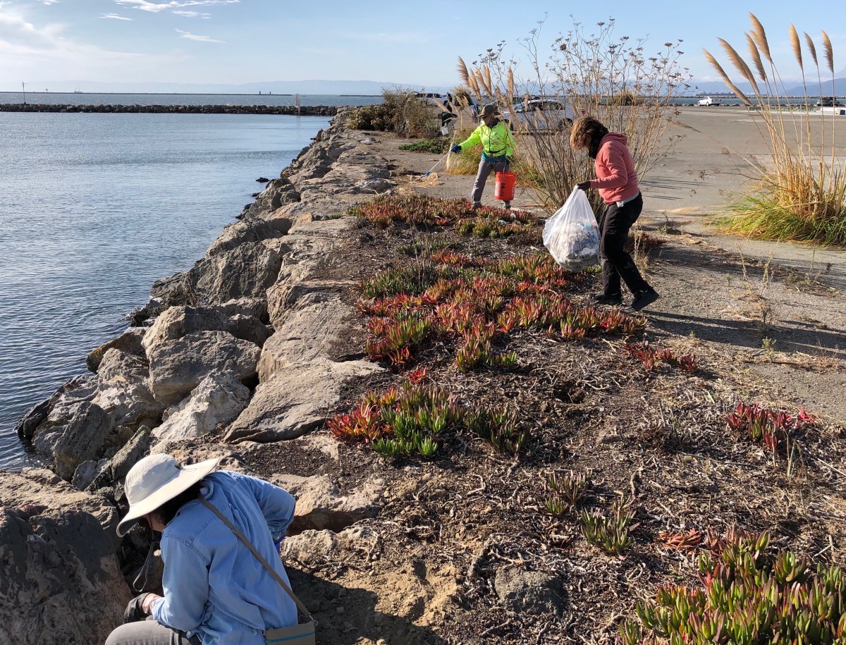
De-Pave Park master plan kick-off meeting April 15th

If participating in creating a wetland ecological park in Alameda is of interest to you, mark your calendar for this upcoming outdoor event.

The master planning process for De-Pave Park on the west side of Alameda Point’s Seaplane Lagoon begins with an in-person workshop on Saturday, April 15, from 3:00 to 5:00 p.m.

Continue reading “De-Pave Park master plan kick-off meeting April 15th”

De-Pave Park slated to receive planning grant

Alameda’s proposed De-Pave Park project has made the short list for this year’s grant funding from the San Francisco Bay Restoration Authority.  The Restoration Authority Board will hear staff recommendations and provide input at its February 25, 2022, meeting, with authorization coming at its April meeting. 

Of this year’s 18 applicants, six have been selected for funding.  The recommended award for De-Pave Park is $800,000.  This amount is expected to cover the cost of developing a master plan, as well as the first level of construction drawings. 

Continue reading “De-Pave Park slated to receive planning grant”

Security Firm Is Failing Alameda Point

Despite the city’s attempts to curb large unauthorized car events on the west side of the Seaplane Lagoon at Alameda Point, wimpy gates and lax security have not stopped abuses or muscle-car madness.

On October 19, 2021, the City Council voted to block off most of the auto traffic at the future De-Pave Park area.  In November, yellow-painted concrete blocks were placed around the area next to the Seaplane Lagoon shoreline, which is intended for the quiet enjoyment of cyclists and walkers. 

Continue reading “Security Firm Is Failing Alameda Point”

Volunteers clean up trash on shoreline of future De-Pave Park

It was an unsightly mess that motivated concerned residents to spring into action. 

About 20 volunteers showed up on Sunday morning, October 17, to pick up the blanket of litter along the western shoreline of the Seaplane Lagoon at Alameda Point.  This area is a popular destination for recreational visitors, many of whom leave their trash on the ground.  The city recently took steps to stop side-show activity there.

Continue reading “Volunteers clean up trash on shoreline of future De-Pave Park”

City blocks car access to Alameda Point waterfront

On Sunday, April 19, Vice Mayor Frank Matarrese drove to the shoreline on the west side of the Seaplane Lagoon, and within minutes of arrival he was ordered to leave the area by Alameda Point security. He was not alone. Anyone visiting the area, which is designated as a future naturalized park on planning maps, was subject to the same experience.

Alameda Vice Mayor Frank Matarrese being ordered to leave the shoreline of Alameda Point by Alameda Point security on Sunday, April 19, 2015.

The Navy temporarily restricted public access to the area over the last few years because of environmental cleanup, but removed its fencing in mid-March allowing the public to once again visit the waterfront.

Nanette Mocanu, the city’s Economic Development Division Manager, explained that the city immediately re-established the no public access rule because of a case of illegal dumping and evidence of car “side show” activity. “We will be installing our own fencing that will prevent car traffic to the area, except for the tenants,” said Mocanu.  “There will be a pedestrian gate to allow people to walk along the waterfront area.”  

Car tire tracks at Seaplane LagoonAn investigation of the tarmac area revealed a few tire tracks, but otherwise it was clean. Similar displays of tire tracks from “side show” activities appear prominently throughout Alameda Point. Illegal dumping has been a problem at the former Naval Air Station since its closure, concentrated mainly in abandoned housing areas, not on the tarmac.  

Most visitors to the area have one destination in mind, the southern shoreline facing San Francisco Bay. They are usually there for only short periods of time. Under the city’s car restrictions, visitors arriving in cars will have to walk four tenths of a mile across a paved landscape to arrive at the Bay shoreline. Access will be limited to those with the desire and mobility to make the trek out to the shoreline vista point.

Car visitors to shoreline

Matarrese was not pleased with the city’s plan to restrict the area. “I do think there is a better way, like opening and closing the gate at sunrise and sunset, since the guard is out there anyway,” said Matarrese. “I’d even be able to live with the stated restrictions if it meant a concerted effort, with a plan and a timeline, to build the park described in the waterfront plan adopted last year.”

The Town Center and Waterfront Precise Plan, approved by the city council in July 2014, calls for the western side of the Seaplane Lagoon to become “a park for visitors to enjoy nature and appreciate ecologically rich constructed habitat areas.” Referred to as De-Pave Park, it “combines a proactive ecological agenda with a compelling visitor experience by placing a picnic, camping and interpretive program within a large scale sustainable landscape,” states the plan. “The landscape strategy is to transform this vast paved area into a thriving ecology by removing the paving and nurturing ecological succession.”

Published in the Alameda Sun.

Waterfront plan showing proposed natural park on west side (left) of Seaplane Lagoon.

The distance to walk to the Bay shoreline from the gate, at the west side of Seaplane Lagoon, looking south.

Family bicycling to the shoreline on west side of Seaplane Lagoon.

Cyclists on the shoreline

Mother and son cycling on west side of Seaplane Lagoon.

Two visitors to west side of Seaplane Lagoon shoreline being ordered to leave by security.

Security guard telling car driver and his friend they had to leave.

This driver was approached by security shortly after photo was taken as he was leaving.

Vista Point

Find the wetland near Building 25 at Alameda Point

(Hint: It’s behind Building 25 and was temporarily enlarged on Thursday.)

Rain on Thursday, December 11, led to flooding on three sides of Building 25 at 1951 Monarch Street, as well as on the south side of the Control Tower.  Building 25 is adjacent to the wetland on federal VA property called Runway Wetland.   

Flooding next to Building 25 (behind camera), looking toward Control Tower and Port of Oakland.  VA federal property on the left.
Flooding next to Building 25 (behind camera), looking toward Control Tower and Port of Oakland. VA federal property on the left.

Building 25 was slated for removal in the original Waterfront Town Center conceptual drawing to make way for a wetland park called De-pave Park.  By early 2014, city staff decided instead to lease the building, convincing the city council to follow.  The plan now calls for protecting the building with a levee, which could be decades away.   Continue reading “Find the wetland near Building 25 at Alameda Point”

Phony green shoreline park plans for Seaplane Lagoon at Alameda Point

The drawing and images for the so-called “De-Pave Park” on the western side of the Seaplane Lagoon would be something to cheer about if the park had any chance of ever being created. The text of the city’s recently released Town Center and Waterfront Plan, however, allows existing industrial buildings along the western edge of De-Pave Park to remain “if needed.”

Proposed De-Pave Park location w:buildings

Such a caveat sets the framework for never moving forward with the plans. If the buildings are being leased, the buildings will be “needed.” If the buildings are needed, then the pavement around them will also be needed. The city is continuing to market these buildings to tenants and, thus, there’s not likely to come a day when we try to secure grant money to develop the park.

Building 29 blight

This is a change from the first presentation of De-Pave Park in 2013 when the Town Center and Waterfront Plan was rolled out. The existing structures were not shown in that drawing.  The community was led to believe that all structures would be removed to provide a natural wetland-oriented transition to the existing Runway Wetland on federal property. Not so anymore. The structures can stay.

Conceptual plan presented in 2013 did not indicate that any buildings would remain between De-Pave Park and the Runway Wetland on the federal property.

2014 De-Pave Park plan shows dashed lines indicating existing structures that will be allowed to remain "if needed."
2014 De-Pave Park plan shows dashed lines indicating existing structures that will be allowed to remain “if needed.”  Floating wetlands do not exist right now, and probably never will.

The infrastructure plan now has a levee protecting the 55-foot tall “Building 25” from sea level rise. There would be no reason to protect this eyesore if it was slated for permanent removal. Furthermore, the building is part of the mixed-use commercial and residential waterfront zone where even a hotel is permitted.

55-foot tall "Building 25" that will be protected by a levee, and remind campers that they are on an old military industrial site, as they gaze at the night stars.
55-foot tall “Building 25” that will be protected by a levee, and remind campers that they are on an old military industrial site, as they gaze at the night stars.

The plan’s conceptual drawing and photo collage showing campers, hikers, and grasslands does not include a view to the west, and with good reason.  It would show the industrial legacy that will interrupt the potentially expansive views toward the west. It’s deceptive advertising.

Looking toward the Seaplane Lagoon in conceptual drawing for De-Pave Park.  No drawings are offered to inform viewers that directly behind this vantage point are old industrial buildings that will be allowed to stay "if needed."  There is currently no plan to remove the industrial buildings.
Looking toward the Seaplane Lagoon in conceptual drawing for De-Pave Park. No drawings are offered to inform viewers that directly behind this vantage point are old industrial buildings that will be allowed to stay “if needed.” There is currently no plan to remove the industrial buildings.

Parks, as we’ve learned during the new zoning designations for Alameda Point, are zoned Open Space. This “park” is not zoned Open Space. It’s another indication that the so-called “De-Pave Park” is phony.

Changing the western shoreline of the Seaplane Lagoon to a wetland-grassland landscape connected to the Runway Wetland would implement climate change adaptation goals and carbon sequestration goals. Without a commitment by the city to implement De-Pave Park in the Town Center and Waterfront Plan – including removal of all buildings on the western side of the Seaplane Lagoon – a great opportunity to help rebalance the San Francisco Bay ecosystem will fall through the loopholes.

City Hall is requesting comments on the draft plans for the Town Center and Waterfront Plan by May 15, in preparation for a June 9 Planning Board meeting. The plan will be the guiding document on how, where, and what gets built around the Seaplane Lagoon. The city council is expected to approve the plan in July. Comments can be submitted to city planner Andrew Thomas at athomas@alamedaca.gov for forwarding to the Planning Board.

Red line indicates levee that will protect "Building 25."
Red line indicates levee that will protect “Building 25.”

Western side of the Seaplane Lagoon with potential for a major rebalancing of the Bay ecosystem.
Western side of the Seaplane Lagoon with potential for major improvements to the Bay ecosystem.

Seaplane Lagoon looking west, with blighted viewscape that will allowed to remain.  San Francisco is in background.  "Building 25" is the large building on the right that will be saved by a levee.
Seaplane Lagoon looking west, with blighted viewscape that will be allowed to remain. San Francisco is in background. “Building 25” is the large building on the right that will be saved by a levee.


Reference:  Open Space, Landscape, and Sustainability sectionDraft Town Center and Waterfront Precise Plan for Alameda Point.