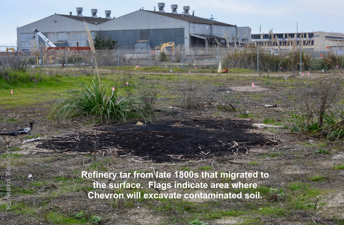
De-Pave Park master plan kick-off meeting April 15th

If participating in creating a wetland ecological park in Alameda is of interest to you, mark your calendar for this upcoming outdoor event.

The master planning process for De-Pave Park on the west side of Alameda Point’s Seaplane Lagoon begins with an in-person workshop on Saturday, April 15, from 3:00 to 5:00 p.m.

Continue reading “De-Pave Park master plan kick-off meeting April 15th”

Opening of park at Seaplane Lagoon highlights climate change

On April 9, 2022, the first phase of the terraced Alameda Point Seaplane Lagoon waterfront park officially opened with cultural performances.  One of the groups christening the new three-acre park was Fog Beast, in collaboration with the Shawl Anderson Youth Ensemble.  Their performances captured the nature of the park, highlighting climate change and sea level rise.

Continue reading “Opening of park at Seaplane Lagoon highlights climate change”

Developer proposes changes that would cheapen waterfront area

On Monday, December 9, 2019, the Planning Board will consider approving changes to the Waterfront Park and Block 11 at Site A at Alameda Point that were previously approved in 2016 “in an effort to reduce escalating construction costs and long term maintenance costs for both the building and the park.”  The City has already granted numerous modifications to the development agreement, with good reasons.  The current request does not merit approval because it would cheapen the waterfront focal point. Continue reading “Developer proposes changes that would cheapen waterfront area”

Unexpected Environmental Review of VA Project

The City of Alameda announced on February 22 that it will be preparing an environmental impact report (EIR) on the Department of Veterans Affairs (VA) project for a health clinic and columbarium cemetery at Alameda Point. The VA completed its environmental review for the project in 2013. The deadline for commenting on what the city should evaluate is March 22.

The belated environmental review was triggered by California regulations requiring a state EIR in order for the Regional Water Quality Control Board to approve the VA’s wetland mitigation plan.

An EIR is also required for City of Alameda approvals. “Although construction of federal facilities by federal agencies is typically exempt from local land use regulations and review,” said city planner Andrew Thomas, “in this case, the VA plans to construct an access utility/road on approximately 6-acres of city land to the east of the VA Transfer Parcel and two new storm drains across city-owned land to the north of the VA property, which will require approval of easements from the city, which are discretionary actions subject to CEQA [California Environmental Quality Act].”

Revisiting the project’s environmental impacts six years after the VA completed its review presents an opportunity to evaluate the potential environmental benefits of locating the medical clinic and benefits offices in the business “Enterprise District” rather than in the open space on the former airfield. Continue reading “Unexpected Environmental Review of VA Project”

City misses chance to embrace wetlands at Alameda Point

The city and its consultant recently released a report outlining what will be included in the new climate action plan for Alameda.  What it reveals, unfortunately, is their resistance to thinking big.

The process for updating Alameda’s climate action plan began as a promising effort for a comprehensive look at what it means to adapt our entire environment to climate change.  It is winding up with a narrow focus on protecting local real estate, which they refer to as “vulnerable assets.”

The city has rejected a broader scope of action that would include “opportunity assets,” as in opportunities to improve the natural environment, not just the built environment.  Areas at Alameda Point not slated for development must be viewed as an opportunity asset that can be re-purposed for the good of the environment. Continue reading “City misses chance to embrace wetlands at Alameda Point”

VA project adds to legacy of letdowns on airfield

A legacy of disappointment continues on the aircraft runway area at Alameda Point.  In the nearly 20 years since the Navy ended operations there, the community has lost 74 acres of open space that was once slated to become city property.  The community has also lost the possibility for a 550-acre national wildlife refuge and a state-of-the-art community hospital to be run jointly with Alameda Healthcare District to serve veterans and non-veterans. 

There is still no groundbreaking scheduled for the veterans’ clinic and columbarium.

U.S. Department of Veterans Affairs (VA) plans for outpatient clinic, medical and benefits offices, and a national cemetery at Alameda Point. San Francisco in background.

The only recent expenditures on the 624 acres of federal property, now owned by the Department of Veterans Affairs (VA), have been to fund landscaping over an underground dump and the management of the endangered least terns that nest on 10 acres, which includes the widespread application of herbicides and vegetation removal on 300 acres of pavement at the direction of the U.S. Fish and Wildlife Service. 

Mitigating the loss of wetlands appears to be the only planning underway. Continue reading “VA project adds to legacy of letdowns on airfield”

Waterfront Park plans – Public comment welcomed

The Planning Board and the Recreation and Park Commission will be making comments this week on the first phase of a waterfront park being planned for the north side of the Seaplane Lagoon at Alameda Point.  The public is invited to offer comments.

AP Waterfront Plans

The Planning Board meeting is on Monday at 7 PM at City Hall.  The Recreation and Park Commission meeting is on Thursday at 7 PM at City Hall.

Below are excerpts from the city staff report, along with a series of images in an easy-to-examine format excerpted from the complete design proposal.  Click on any image to enlarge.

“Alameda Point Partners (APP) has been working with their design consultants, park planners, a Planning Board Subcommittee and City staff to prepare detailed designs for the individual buildings and parks within Site A.  APP has submitted an application for design review for a 2.63-acre Phase 1 of the waterfront park along the northern edge of the Seaplane Lagoon that is intended to be constructed concurrent with Block 11.”

“Phase 1 Waterfront Park is designed to provide a variety of public spaces for passive recreation and opportunities for the public to enjoy the waterfront location and special events, and appreciate the views of the San Francisco skyline and the historic row of seaplane hangar buildings at the entrance to the Historic District, along the northern edge of the Seaplane Lagoon.”

AP Waterfront Plans

“The 2.63-acre Phase 1 Waterfront Park is designed to create three primary sub-areas (i.e., the Overlook, the Promenade & Terraces, and the Taxiway).”

AP Waterfront Plans

The Overlook includes a pavilion for a café with outdoor seating and restrooms, as well as an elevated salvaged or reclaimed wood outdoor area for overlooking the promenade at the water’s edge, as well as portions of the promenade adjacent to the water.  The Overlook also accommodates flexible event and programmable space.”

AP Waterfront Plans

The Promenade and Terraces consists of a series of terraces and promenade spaces leading down to the water’s edge that provide for a variety of more passive spaces for enjoying and experiencing the waterfront.  Access to the waterfront promenade allows for universal design through slightly sloped walkways and seating elements that provide for a variety of all age groups and needs.”

AP Waterfront Plans

The Taxiway area is intended to pay homage and respect to the historic elements of the former NAS Alameda by engraving a timeline along the major east west gathering area into the concrete to remind and educate the public about the history of the site and the Historic District, and by minimizing tree plantings and planted areas to preserve the ‘openness’ of the historic taxiways consistent with the Historic District guidelines.  This area includes open and unobstructed areas planned for special events and food trucks and future retail buildings as conceived in the Site A Development Plan and a temporary multi-purpose lawn for active recreation uses until future phases of the Waterfront Park are constructed and this area is designed consistent with the areas to the north.”

AP Waterfront Plans

Address Sea-Level Rise.  With anticipated sea level rise, the existing taxiways will flood.  Consistent with the approved MIP and San Francisco Bay Conservation and Development Commission (BCDC) policies, the Phase 1 Waterfront Park is designed to address 24-inches of sea level rise and additional sea level rise in future years beyond 24 inches through adaptive management strategies.”

“The Phase 1 Waterfront Park design maintains the “horizontality” of the space and minimizes the use of walls in order to respect the cultural landscape guidelines for the Historic District.

“Additionally, the sea level rise strategy is designed around a series of short terraces spread over a larger space to minimize the impression of changes in elevation.  This approach also allows for the preservation of the existing bulkhead, which is a character defining feature of the Historic District.   During storm events and “King Tides” (unusually high tides), the bulkhead and adjacent promenade will flood occasionally as the sea level rises over time, but major portions of the public park and Bay Trail will remain above the flooded areas behind the stepped terraces.  As such, the design balances the competing needs to address sea-level rise, preserve the bulkhead, and maintain the horizontality of the site.”

AP Waterfront Plans

AP Waterfront Plans

AP Waterfront Plans

AP Waterfront Plans

AP Waterfront Plans

AP Waterfront Plans

AP Waterfront Plans


AP Waterfront Plans

AP Waterfront Plans

Later phase. Not part of Phase 1.

AP Waterfront Plans

AP Waterfront Plans

Click on any image to enlarge.

AP Waterfront Plans

AP Waterfront Plans

AP Waterfront Plans

AP Waterfront Plans

AP Waterfront Plans

AP Waterfront Plans

AP Waterfront Plans

AP Waterfront Plans

AP Waterfront Plans

AP Waterfront Plans

AP Waterfront Plans

AP Waterfront Plans

AP Waterfront Plans

AP Waterfront Plans

AP Waterfront Plans

AP Waterfront Plans

AP Waterfront Plans

AP Waterfront Plans

AP Waterfront Plans

AP Waterfront Plans

Click on image to enlarge.

AP Waterfront Plans

AP Waterfront Plans

AP Waterfront Plans

AP Waterfront Plans

AP Waterfront Plans

AP Waterfront Plans

AP Waterfront Plans

AP Waterfront Plans

AP Waterfront Plans

AP Waterfront Plans

AP Waterfront Plans