Conservation of wildlife isn’t just important at Crab Cove
Visitors flock to Crab Cove, a State Marine Conservation Area, to learn about and experience the Bay’s sea dwellers. The educational lessons at the Crab Cove Visitor Center are equally relevant throughout the waterway south of the USS Hornet at Alameda Point where even more creatures thrive in relative obscurity.
The area encompasses an interconnected web of vegetation, birds, seals, fish, mollusks, crustaceans and worms. Ghost shrimp, bat rays, leopard sharks, striped crabs, mussels, California sea hares and fish with light-emitting diodes are just a sampling. A 36-foot-wide rock wall, known as a breakwater and built by the Navy in 1945, forms the mile-long southern boundary.
Ghost shrimp at Breakwater Beach, Alameda Point. Red spots on shrimp are baby shrimp. Click on photo to enlarge.
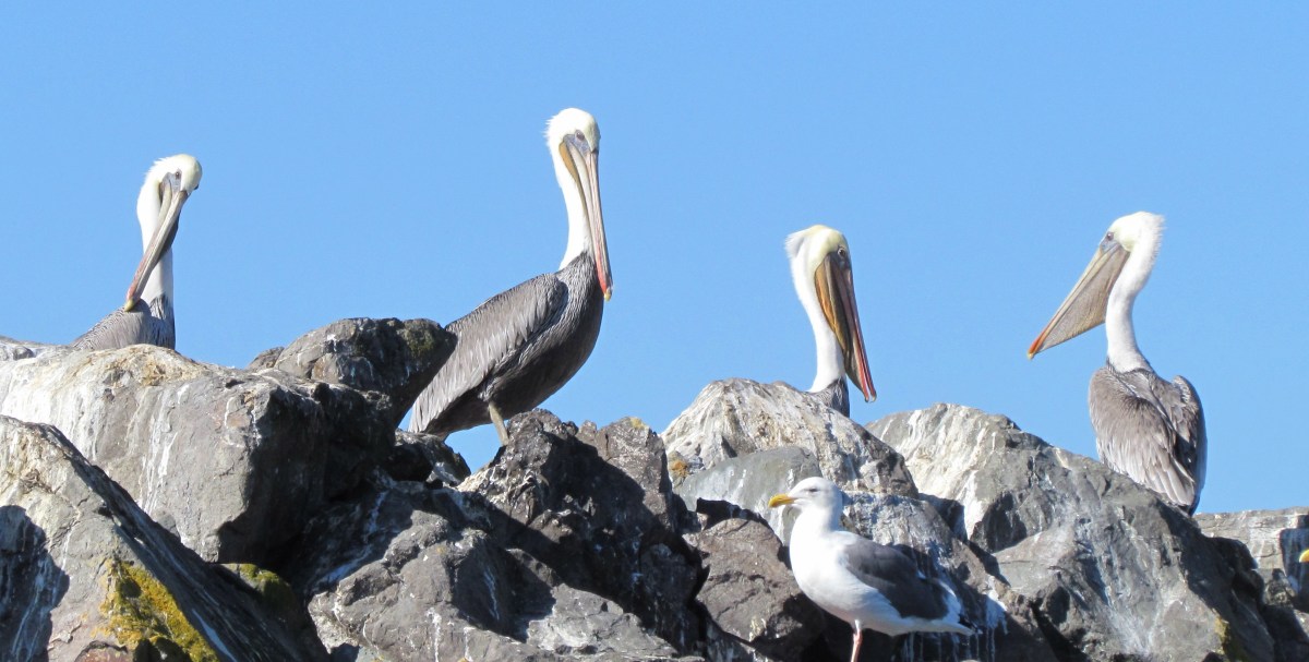
L-shaped Breakwater Island – largest brown pelican roosting site in San Francisco Bay – with San Francisco in background. Breakwater rocks in foreground extend back to Encinal Boat Ramp. Former Naval Air Station is located to the right.
The successful recovery effort for the once endangered California brown pelican is evident every summer through fall on Breakwater Island, an area which forms the beginning of the Alameda Point Channel leading to the ship docks and Seaplane Lagoon. The breakwater is a wall of boulders built up from the Bay floor to reduce wave action in the harbor.
California brown pelicans were listed as an endangered species in 1970. The pesticide DDT was identified as the cause of their decline. It caused reproductive harm, and altered the birds’ calcium absorption, which led to thin eggshells that would break under the parents’ weight. Use of DDT was banned in the United States 1972.
A recovery effort was launched in the 1970s on Channel Islands National Park off the coast of Santa Barbara. The only breeding colonies of California brown pelicans in the western United States are within Channel Islands National Park on West Anacapa and Santa Barbara islands.
California brown pelican preening on Breakwater Island.
In the summer and fall, the brown pelicans can range from nesting colonies in Mexico and the Channel Islands all the way up to British Columbia. Alameda Point’s Breakwater Island is the largest roosting site in San Francisco Bay. A safe, secure roosting area is essential for pelicans to rest, preen, dry their feathers, maintain body temperature, and socialize.
When the Naval Air Station was still active, the Navy enforced restrictions against boats landing on the Island and posted signs that warn against disturbing the birds. Since the base closed, there has been no one to enforce regulations against disturbing the pelicans.
California brown pelicans relaxing on Breakwater Island on sunny fall day. Their mouth sack is the largest of any bird and is used to scoop fish when they plunge into the water.
The California Brown Pelican was removed from the Endangered Species List in 2009 after an almost 40-year recovery. There is currently no plan to look out for the welfare of these magnificent birds after the base is transferred out of Navy ownership. One way to ensure adequate protection and provide public education and appreciation of this unique ecological asset is to have it be part of an “Alameda Point Wildlife Conservation Area.” The East Bay Regional Park District would be an excellent agency to manage it; they already have a marine conservation area at nearby Crab Cove.
Young California brown pelican with leg band.
Young brown pelicanOld-timer. Brown pelicans can live to 30 years.
Close-up photos of Breakwater Island pelicans were taken in October 2012 from a kayak.
View more Breakwater Island pelican photos in the Flickr photo set.
This story is reprinted on the Golden Gate Audubon Society’s blog Golden Gate Birder.
Update – October 23, 2012
The brown pelican pictured above with a leg band reading “K69” was brought to the International Bird Rescue clinic in Cordelia near Fairfield, CA on July 9, 2012 in a thin and weak condition. It is less than a year old. After a one-month rehab, it was released at the Elkhorn Slough Estuarine Reserve near Watsonville on August 10. A blue band on a pelican leg means it was given a helping hand at one of thetwo clinics operated byInternational Bird Rescue– located in the San Francisco Bay Area and Los Angeles. Some of their released pelicans have been spotted in Oregon and Washington. If you see a pelican with a blue leg band, they’d like to hear about it.
Alameda Point Open Space: East Bay Regional Park District’s Emerging Role and Where to Locate the VA Outpatient Facility
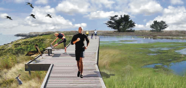
Boardwalk through proposed wetlands
Golden Gate University’s Center on Urban Environmental Law (CUEL) recently sent aletterto Robert Doyle, General Manager of the East Bay Regional Park District (EBRPD); John Russo, Alameda City Manager; and Larry Janes, Capital Assets Manager for the Veterans Administration Sierra Pacific Network commenting on the ongoing discussion about the location of a VA outpatient clinic at Alameda Point and the management of open space.
In the letter signed by co-director Paul Kibel, he states that a “more expansive role for EBRPD at Alameda Point aligns well and advances several of the proposals in CUEL’s September 2011 Flight Park Booklet. First, consistent with the Hannover Principles on Land Use, granting EBRPD authority to manage open space on both the City and federal portions of Alameda Point will help ensure that such management is based on integrated protection of habitats and viewsheds rather than arbitrary jurisdictional boundaries.”
“Second, and once again consistent with the Hannover Principles, allowing EBRPD to plan open space at Alameda Point on this broader geographic scale will facilitate the creation of self-regulating and self-adjusting habitats and landscapes (that require less maintenance costs down the road).”
Perimeter boardwalk (Bay Trail) through park
“Third, the appointment of one qualified agency (EPRPD) to coordinate and oversee all the wetlands at Alameda Point will help streamline the process for establishing a conservation mitigation bank to fund the design, enhancement and expansion of wetlands resources throughout the entire Alameda Point acreage.”
Unresolved issues – alternative site recommendation
Highlighted parcel at Alameda Point that was offered to the Berkeley Lab for a second campus. USS Hornet and Seaplane Lagoon to the left.
While supportive of locating a VA facility at Alameda Point, CUEL questions the wisdom of locating the VA building facilities on the Northwest Territories due to view impairment, earthquake seismic safety, traffic, and transit accessibility concerns. They suggest an alternative site: The one that the city was offering to the Berkeley Lab for its Second Campus.
The borderless ecosystem – On September 1, 2011, Golden Gate University’s Center on Environmental Law published their proposal for a unified planning process and expansive view for open space at Alameda Point. The central theme of their effort is that the true potential for conservation at Alameda Point lies in thinking of the area as one contiguous ecosystem of land and water. In doing so, not only is there benefit to wildlife and the environment in general, there is also benefit to our efforts at economic development by making Alameda Point a highly desirable location with a signature identity – Flight Park.
Perimeter boardwalk (Bay Trail) through park
Flight Park is their suggested name for a unified open space system that would bring to mind larger-scale landmark open space systems like the Golden Gate National Recreation Area. Bringing together regional, state, and federal agencies to adopt and implement conservation efforts will be far more effective in the long run than waiting for, say, the VA to appropriate money for habitat conservation (not their core mission), or the city of Alameda getting enough attention to secure millions in wetlands monies.
Moving the VA facilities – Perhaps the most controversial proposal within the Flight Park concept is moving the proposed VA facilities off of the Wildlife Refuge to a spot further east at Alameda Point. While coming late in the process for transferring land to the VA, it is not without merit. The Golden Gate Audubon Society has long opposed the sighting of VA buildings on the Wildlife Refuge as an intrusion into the habitat of the endangered California Least Tern. The Flight Park designers see the VA buildings as a visual obstruction on an otherwise wild and open bay front parcel.
Boardwalk through proposed wetlands
There is good reason for the VA to work with the City of Alameda on moving their buildings, if not their columbarium, closer to the old “Main Gate” on the north side of Alameda Point. Services will be easier to get to for veterans, and the infrastructure to their site will be less expensive. There is still time – the VA has not spent their $17 million for this year on design, and therefore they have not requested money for the project in next year’s budget proposal.
The East Bay Regional Park District has been ready and willing to take on the management of regional park facilities at Alameda Point for over a decade. In 2009 they set aside $6.5 million for Alameda Point shoreline restoration and the Bay Trail.
Existing wetlands on Northwest Territories
Wetlands Mitigation Bank – Professor Paul Kibel, co-director of the Center on Urban and Environmental Law and leader behind the Flight Park concept, argues that there is also funding potential in the creation of a Wetlands Mitigation Bank such as has been created in many California communities to accumulate funds for creating or restoring wetlands. An experienced environmental lawyer, he has offered to assist the city in any way he can in setting up such a wetlands bank. One of our first contributions would likely come from the Navy, which will owe us some wetlands due to their coming remediation plans for the Northwest Territories. Typically, two acres of wetland must be created for each single acre removed.
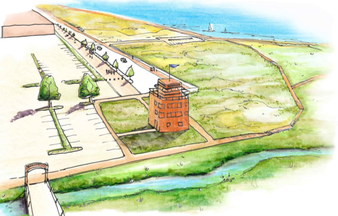
Seaplane Lagoon grassland promenade with Control Tower converted to nature observation center
In Sum – The Flight Park drawings offer an inspiring look at what could be at Alameda Point. It is a vision that merges well with recent sustainability presentations that call for diverting storm water to wetlands and marshes at Alameda Point. Urge our city council to discuss this initiative. It would build on Alameda’s reputation as a city dedicated to environmental sustainability.


 through park")