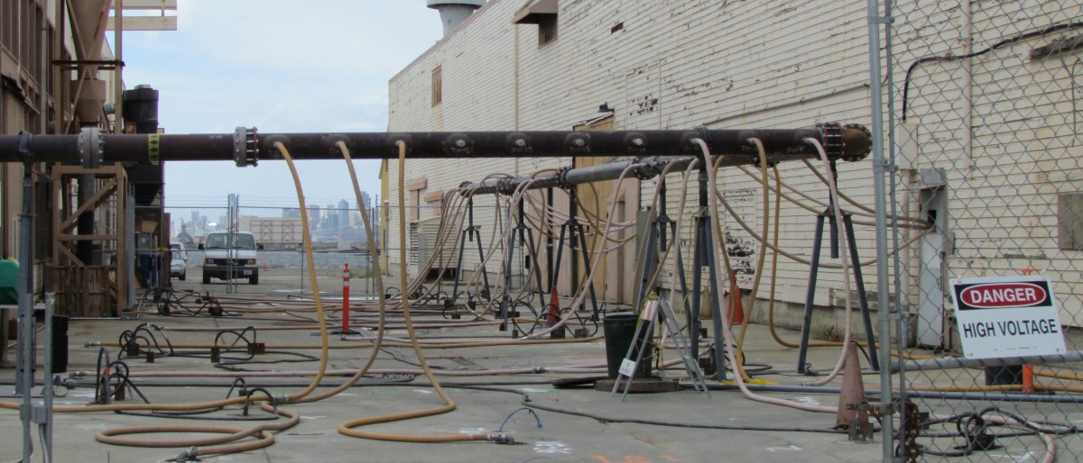
Seaplane Lagoon cleanup dredging completed [video and slideshow]

Dredging northwest corner of Seaplane Lagoon

Environmental cleanup of the Seaplane Lagoon has centered on two areas where storm sewers drain into the lagoon.  It was commonplace to discharge all sorts of chemicals down storm sewer lines prior to the passage of the federal Clean Water Act in the early 1970s.  Contaminants such as PCBs, cadmium, lead, pesticides, and radium have been found in the sediment around the sewer discharge points.

Prior to dredging, sewer lines leading to the northeast and northwest corners were either replaced or flushed out.  An underwater debris pile of metal and wood was also removed at the northeast corner before dredging.

The Northeast Corner

Setup for the 6.5-acre northeast dredging area began in late 2010, and dredging was completed in April of 2011.  The total amount of sediment removed was 75,628 cubic yards.  Even though the contamination depth was three feet, the dredging went to five feet.

Only 1,719 cubic yards of sediment were transported to hazardous waste disposal sites, of which 11 cubic yards went to a low-level radiological waste disposal site because of the radium-226.  The rest of the sediment was determined to be safe enough for reuse, in large part because the contaminants were diluted by the over-dredging of clean sediment.  The clean sediment has been stockpiled on the western end of the Wildlife Refuge for future use in capping the landfill disposal sites 1 and 2.

All of the drying pad materials for the northeast corner have been removed, which will allow for the fence to be moved.

The Northwest Corner

Concrete drying pad installed at northwest corner of Seaplane Lagoon

Setup for the 3.3-acre northwest corner began in October of 2011 with the construction of a concrete, waterproof drying pad.  Prior to dredging, a sunken barge was demolished and removed.  The barge pieces were scanned for radiation, but none was found.  The 66 tons of scrap iron was sent to a recycling facility.

Dredging started on January 16 and ended on February 22.  The dredging at the NW corner went much faster than the early dredging, partly because of the smaller area, and partly because of heftier dredging equipment.

Unlike the NE corner, however, the sediment here is expected to contain higher levels of radium-226 because the sewer line leading here was highly contaminated.  As was the case at the NE corner, this sediment will have to dry out before being tested and disposed of.  The project should be completed and everything removed by December.

The price tag for all of the Seaplane Lagoon dredging and hauling away sediment, when completed:  $46 million.


This slideshow requires JavaScript.

Groundwater cleanup back on track at heat treatment site

The groundwater remediation project between two buildings near the East Gate entrance, in the area known as Operating Unit 2B, finally got underway after a long delay in startup since last spring.  

During set up, one of the 30-foot-long steel electrodes driven into the ground to generate heat struck a plastic sewer line.  The sewer line was not on any maps and was undetectable through scanning since it is not iron.  Operation of the system began last month after a sewer line bypass was installed, and it will continue through May.

Heating and extraction of solvents in groundwater between East Gate entrance and Seaplane Lagoon.

The contamination is from nearby aircraft maintenance operations that resulted in chlorinated solvents, used in cleaning aircraft parts, ending up deep underground in the groundwater.  Of the three most common methods for cleaning up groundwater contaminated with solvents and fuels – pumping in neutralizing chemicals, heating up the ground to vaporize and extract the contamination, and bioremediation using microbes – the heat treatment method was chosen for this site because it is the fastest.

Graphic illustration of heat treatment system. Brown electrodes are heated with electricity, which heats the soil and groundwater, creating steam and toxic vapors that are sucked out into red pipe. Navy graphic.

It takes weeks for the ground to get to the target temperature of 194 degrees, which is the temperature at which the solvent boils and turns to vapor.  Pipes at ground level suck the vapor out of the ground and channel it through a large pipe to the granulated activated carbon filter system.

Granulated activated carbon filter system in tanks. Water vapor and toxic vapors are captured and separated.

Other groundwater contamination nearby will be treated by a different method not yet announced.  The Alameda Point electrical substation is near the other treatment area, and underground electrical lines leading every which way preclude the use of electrodes to heat the groundwater.

See also, “Cleaning up a toxic groundwater plume using heat.”

Click here > for background info on this cleanup area.

March cleanup meeting announced

Restoration Advisory Board

Naval Air Station, Alameda (Alameda Point)

March 8, 2012       6:30 PM

Location: Alameda Point – 950 West Mall Square (Alameda City Hall West) Room 140 – Community Conference Room

Enter from West Midway Avenue at rear of building. 

 Agenda


6:30 – 6:35     Welcome and Introductions    

                              Community and RAB

6:35 – 6:45     Co-Chair Announcements     

                             Navy: Derek Robinson

                             Community: Dale Smith

6:45 – 7:05     Site 17 – Seaplane Lagoon     

                             Dredging Update

                             Navy Project Manager: Mary Parker

7:05 – 7:25     Site 24 – Pier 1 dock area     

                             Dredging Update

                             Navy Project Manager: Lora Battaglia

7:25 – 7:45     Operating Unit – 2B  near East Gate     

                             Underground vapor extraction using heat

                             Navy Project Manager: Curtis Moss

7:45 – 7:55     Update from regulatory agencies     

                             Pankaj Arora, US EPA

7:55 – 8:15     Community and RAB Comment Period

8:15 – 8:30     Approval of Minutes     Review Action Items

                             Dale Smith

8:30                 RAB Meeting Adjournment

Alameda Point Map

Restoration Advisory Board Responds to Navy’s Meeting Cutbacks

Alameda Point RAB meeting

At the October 2011 Alameda Point Restoration Advisory Board (RAB) meeting, the Navy announced that Alameda Point’s monthly RAB meetings would be reduced to quarterly meetings due to budget cutbacks.  The Navy said it would welcome a written response from the RAB on how the Navy might continue to carry out its responsibilities for community dialogue during difficult budgetary times.

On February 22, 2012, the RAB sent a letter to the Navy’s Environmental Coordinator for Alameda Point cleanup, Derek Robinson.  The letter cited the magnitude of the cleanup effort at Alameda Point – 25 percent of the Navy’s nationwide cleanup budget in Fiscal Year 2011 – as justification for having more than four meetings per year.  The RAB offered a reasonable compromise schedule that would add two meetings, bringing the total number of meetings this year to six.  The Navy has already indicated that it would continue to host its annual tour of cleanup sites at Alameda Point, which would be in addition to the six meetings being proposed by the RAB.

The RAB also suggested having more than one cleanup site presentation at a meeting in order to make more efficient use of the Navy’s time and money spent on hosting the meetings.  In past years, multiple presentations were made at meetings, but this practice ended because of the Navy’s concern that the meetings were too long and community members in attendance would leave before the end.

The complete letter is here.

Todd Shipyards copper cleanup

Todd Shipyards/Site 28. Dog Park to left of fence, Port of Oakland on right.

Right next to the Main Street Ferry Terminal, between the Oakland Estuary and the Dog Park, is the Navy’s cleanup Site 28, also known as the Todd Shipyards site.  The contamination at this site — copper and arsenic, and to a lesser extent lead and hydrocarbons — was not the result of Navy activities, even though the Navy owns the property.

Background

Filling in the land with estuary dredge soil contaminated with hydrocarbons from the coal gasification plant that once operated in Oakland was likely responsible for the petroleum-related hydrocarbons in the ground.  The Alameda Mole Railroad operated along this route from 1883 until 1939 and was also a possible contributor to the hydrocarbon residue in the soil.  Non-Navy shipbuilding and repair between 1941 and the 1980s was responsible for lead, arsenic, and copper contamination.

According to the Navy fact sheet, “The property was leased to various entities for non-Navy shipbuilding and repair between 1941 and 1970. The property was purchased from the Navy in 1970 by the Todd Shipyards Corporation, which used the land as an extension of its adjoining shipyard property until 1983, when the property was then sold to Alameda Gateway Limited.  The IR Site 28 portion of the former shipyard reverted to Navy ownership in 1995.”

Paint used on ships

The copper contamination came from paint used on the bottoms of ships.  The paint was an anti-fouling paint that served to prevent the growth of barnacles.  Copper in the paint acted as the biocide, which is why possible leaching into the estuary is a big concern.

Emerging cleanup technology

Todd Shipyard/Site 28 groundwater monitoring well. Alameda Main Street Ferry Terminal in background.

Even though the Navy did not cause the contamination, they are responsible for the cleanup, which it performed in 2010.  They are also responsible for monitoring the groundwater for 10 years to make sure their methods are permanent.  Some of the methods used here were straightforward:  Digging up soil and replacing with new soil.

The copper at groundwater level, however, is being dealt with by an emerging technology called metals immobilization.  In this process a proprietary non-toxic compound is injected into the ground to bind to the copper and cause it to be absorbed into soil particles, which will prevent it from leaching into the estuary and harming aquatic life.  Hence, the term immobilization – the copper is no longer mobile, or able to move.  Water and natural microbes in the ground are what activates this immobilization compound.  A helpful byproduct of this reaction is that food (carbon) for natural microbes is released, further enhancing the effectiveness of this process.

So-called emerging cleanup technologies are halfway between experimental and mainstream.  They have been proven effective in the short term, or in some locations, but have not been in widespread use long enough to be considered 100% effective in every soil type.  No one knows for certain if the binding effect will hold, but pilot lab tests were done on soil from Site 28, and the Navy and regulators fully expect it will work.  If groundwater monitoring indicates that it’s not working, the Navy will have to come up with another plan since there is no statute of limitations on their responsibility for cleanup.

This slideshow requires JavaScript.

Precision Dredging at the Pier Area – with video


Dredging at Pier 1 - Alameda Point

Designing the workplan for dredging toxic sediment next to Pier 1 at Alameda Point required precision so as not to undermine the stability of the concrete posts supporting the roadway that passes along the pier area.  The ground under the water slopes down nearly 40 feet from the cement parking slab adjacent to Wharf Road.  Six-foot sediment core samples were obtained during investigations.  The varying depths of contamination were charted and used to plot a computer program showing a slope profile that not only would accomplish cleanup, but also maintain the stability of Wharf Road.  This means that in some case they are dredging deeper than the contamination.

Dredging toxic mud at the pier area, in what is known as Site 24, got underway in early January 2012.  The Maritime Administration had to temporarily vacate this berth.  Prior Navy activities east of the pier area, which used solvents, paints, sandblasting materials, and hydrocarbons such as fuels and lubricants, led to contamination when waste products, including pesticides, were disposed of down three storm water drains.  The contamination chemicals of concern are cadmium, pesticides, lead, and PCBs.  The dredging process requires two methods – vacuuming mud from under the wharf road that is supported by concrete posts, and dredging with a clamshell scoop in the open water.

Vacuuming mud under roadway

Raft with dredging pump. Hose connects to 4" valve at rear for vacuum dredging under wharf.

The first stage of work, now completed, was vacuuming mud from under the roadway. The specially built dredge pump, equipped with an agitator where the hose contacts the mud, was held in position by a barge-mounted crane that was custom built for this application.  The mud went through a large hose, across the roadway, into a drainage basin and into special geotextile tubes that retain the mud.

The water that drained off of the mud, however, was too muddy to immediately send to a filtration system.  It was first pumped into a large above ground pool of water in order to dilute it.  From there the water was pumped through a series of filtration tanks.  The water is being used for dust control and can also be pumped back into the harbor.

Open water precision dredging

Open water dredging. Sediment deposited into dump truck.

The open water dredging is conducted from a barge using a special clamshell scoop that allows virtually no mud to drip out of the jaws when hoisted out of the water.  This helps to minimize dispersing fine contaminated sediment in surrounding water, which could necessitate repeat dredging.  The scoops of mud are held in the air for about 30 seconds to drain the water before being hoisted over to a dump truck.  The trucks are driven a few hundred yards to a special drying pad to dump the mud.  As the dredge barge moves out of arms length of the wharf, it will have to deposit the mud in a hopper barge that will then be moved next to the wharf where the mud will be unloaded and put into the dump trucks.

Yellow boom holding turbidity curtain to contain disturbed mud, with raft containing turbidity sensors.

The operator of the dredging rig has a real time computer picture of the contour of the underwater ground surface.  The image is aided by positioning sensors on the scoop.  This allows the operator to follow precisely the slope design.  There is also a floating curtain to keep any disturbed contamination within the work area.  At the curtain boom and outside the work area are two floating rafts that detect turbidity, or muddiness, in the water.  These rafts send real time measurements to the dredge operator.  If the turbidity exceeds a certain limit, the dredging is temporarily halted.

Although the Navy periodically dredged the berthing areas for ship and submarine access when the base was open, their dredging was not able to get close to the wharf or under it, leaving the current legacy of contamination.   In the health risk assessment conducted by the Navy, they used the Least Tern as an indicator species since they are the most sensitive birds to forage here, and protecting them would therefore protect all other birds.  Fish consumption by humans was also used to determine that remediation was warranted.  The investigation process that led to this dredging project began with sediment core samples collected in 2005 and 2006.  About 4,000 cubic yards of mud will be dredged.


This slideshow requires JavaScript.