News Release from Alameda Point company Saildrone:
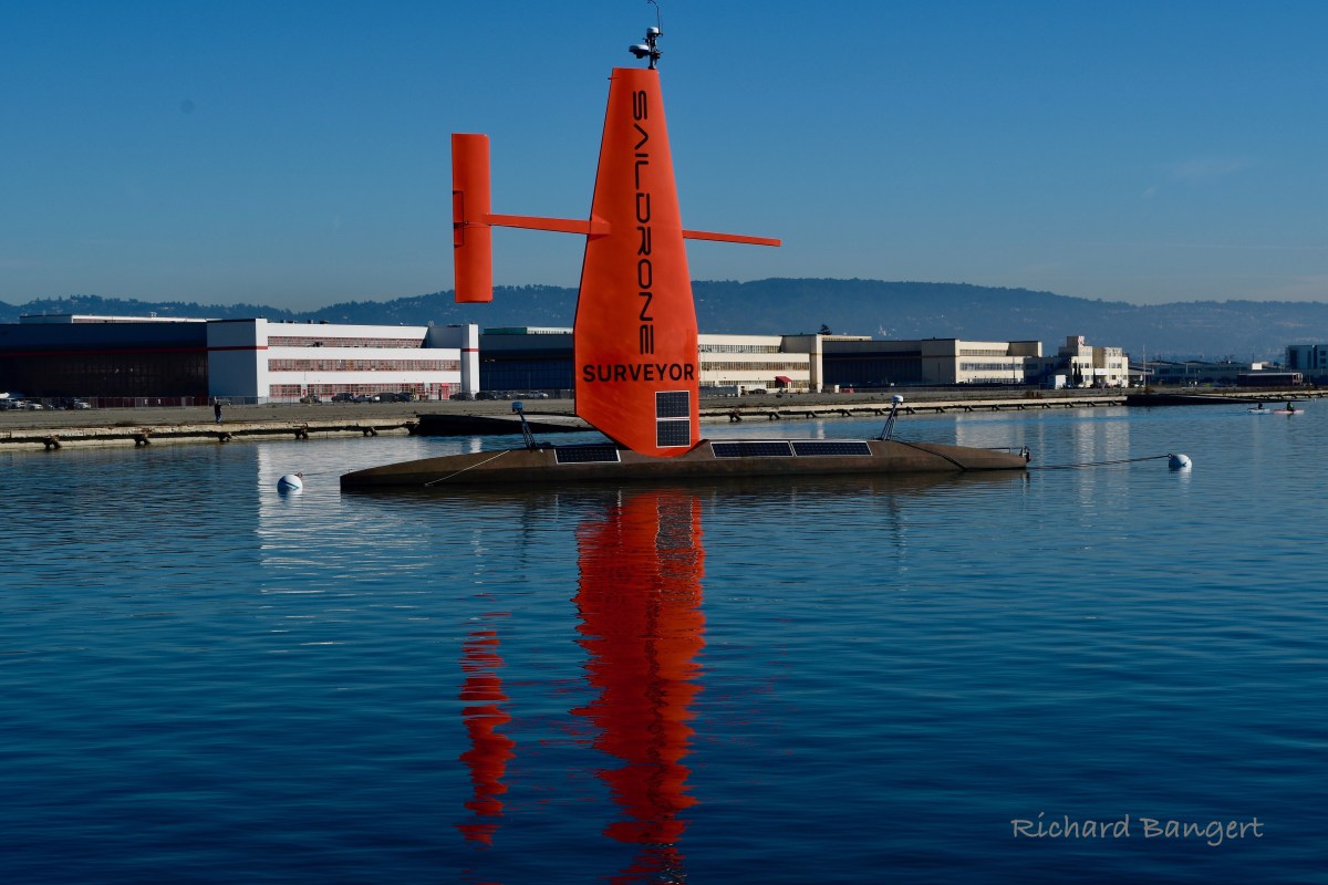
ALAMEDA, Jan 11, 2021 – Saildrone, Inc. has launched a 72 foot (22 m) version of its uncrewed surface vehicles, known as saildrones. Powered by wind and solar energy, saildrones are capable of extreme-duration missions of up to 12 months in the open ocean. This latest and largest version, the first in the Surveyor class of USVs, is called the Saildrone Surveyor, and carries sonar equipment capable of seafloor mapping down to 7,000 m.
Enhanced seabed mapping is vital for the security, safety, and economic health of nation states, and is critical to the growth of the “Blue Economy,” which, according to the Organization for Economic Cooperation and Development (OECD), is valued at $1.5 trillion a year and creates the equivalent of 31 million full-time jobs.
Coinciding with the start of the United Nations Decade of Ocean Science for Sustainable Development, the launch of the Saildrone Surveyor presents a paradigm shift in enhanced seabed mapping, which is currently done with very large and expensive manned ships. The Surveyor, uncrewed and powering its robust sensor suite by harvesting renewable energy, delivers an equivalent survey capability, but at a fraction of the cost and carbon footprint of a traditional survey ship.
With less than 20% of our oceans mapped, we know more about the topography of the Moon and Mars than we do about our own planet. Yet, the shape of the seabed is critical to understanding ocean circulation patterns—affecting climate and weather patterns, tides, wave action, sediment transport, tsunami wave propagation, underwater geo-hazards, and resource exploration.
“We are excited to see the launch of the Saildrone Surveyor,” said Alan Leonardi, director of the NOAA Office of Ocean Exploration and Research. “NOAA is supporting the development and testing of this new uncrewed system because we are confident it will expand the capability of our existing fleet of ships to help us accelerate in a cost-effective way our mission to map, characterize and explore our nation’s deep ocean territory, monitor valuable fisheries and other marine resources, and provide information to unleash the potential of our nation’s Blue Economy.”
The development of this innovative vehicle has been a true partnership. In 2019, NOAA provided a three-year grant through the National Oceanographic Partnership Program to the University of New Hampshire, in partnership with the Monterey Bay Aquarium Research Institute and Saildrone, to integrate and test sensors on the Saildrone Surveyor for mapping the seafloor and revealing life in the water column. While conducting the mapping, samples of DNA, referred to as “environmental DNA,” will be collected to reveal the genetic composition of organisms inhabiting the water.
 “The launch of the Surveyor is a huge step up, not just for Saildrone’s data services but for the capabilities of uncrewed systems in our oceans,” said Richard Jenkins, founder & CEO of Saildrone. “For the first time, a scalable solution now exists to map our planet within our lifetime, at an affordable cost.”
The Saildrone Surveyor leverages the same patented wind-powered technology as the 23 foot (7 m) Saildrone Explorer. The impressive capabilities of Saildrone’s autonomous vehicles have been proven in numerous operational missions for science, ocean mapping, and maritime security, covering over 500,000 nautical miles from the Arctic to the Antarctic. The Saildrone fleet has logged more than 10,000 days at sea in some of the most extreme weather conditions on the planet.
Saildrone is hoping to accelerate many of the global mapping initiatives seeking to give us better insight into our own planet, efforts like The Nippon Foundation-GEBCO Seabed 2030 Project, a collaboration that aims to produce a definitive map of the world ocean by 2030, and the 2019 White House Memorandum on Ocean Mapping that calls for a national strategy for mapping, exploring, and characterizing the US exclusive economic zone.
Quick Facts
- Saildrones are wind and solar powered
- A trim tab on the tail adjusts the wing angle to the wind similar to how an elevator trim tab controls the pitch of an aircraft
- Saildrone has two base vehicles
The Saildrone Explorer – the hull is 7 m (23 ft) long, the wing is 4.5 m (15 ft) tall, the keel draws 1.8 m (6 ft)
The Saildrone Surveyor – the hull is 22m (72ft), the wing is 18m (59ft), the keel draws 4m (13ft) - Saildrone’s current fleet is made up of Generation 5 & 6 saildrones
- Saildrones are designed for missions of up to 12 months
- Saildrone USVs navigate autonomously from prescribed waypoint to waypoint while staying within a user-defined safety corridor, though actively supervised by a Saildrone Mission Control operator
- Saildrone USVs carry approximately 20 science sensors to collect in-situ meteorological and oceanographic data
- Saildrone USVs are not for sale; Saildrone offers mission-as-a-service (MAAS) and data-as-a-service (DAAS) solutions
- Saildrone has operated Arctic, Antarctic, Pacific, Atlantic, and coastal missions collecting data related to weather and climate science, carbon uptake, sustainable fisheries management, animal tracking, satellite calibration and validation, oil detection, and bathymetry

After being employed at the Rework Facility for 33 years as anAvionics Apprentice, Guided Missile Repair, Material
Procurement & Planning, and Weapons Systems Logistics and repair, it is wonderful to see the old Base being used for research & exploration of our oceans and seas. It’s like the old Air Station is “coming of age” a second time.
A facility where, in conjuntion with the ocean cleaning sytems for plastics retreival, is still providing a necessary
operations base for valuable scientific and public information.
“Way to Go”!
LikeLike
Great blog I enjoyeed reading
LikeLike