
The Planning Board and the Recreation and Park Commission will be making comments this week on the first phase of a waterfront park being planned for the north side of the Seaplane Lagoon at Alameda Point. The public is invited to offer comments.

The Planning Board meeting is on Monday at 7 PM at City Hall. The Recreation and Park Commission meeting is on Thursday at 7 PM at City Hall.
Below are excerpts from the city staff report, along with a series of images in an easy-to-examine format excerpted from the complete design proposal. Click on any image to enlarge.
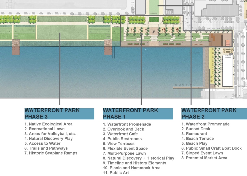
“Alameda Point Partners (APP) has been working with their design consultants, park planners, a Planning Board Subcommittee and City staff to prepare detailed designs for the individual buildings and parks within Site A. APP has submitted an application for design review for a 2.63-acre Phase 1 of the waterfront park along the northern edge of the Seaplane Lagoon that is intended to be constructed concurrent with Block 11.”
“Phase 1 Waterfront Park is designed to provide a variety of public spaces for passive recreation and opportunities for the public to enjoy the waterfront location and special events, and appreciate the views of the San Francisco skyline and the historic row of seaplane hangar buildings at the entrance to the Historic District, along the northern edge of the Seaplane Lagoon.”

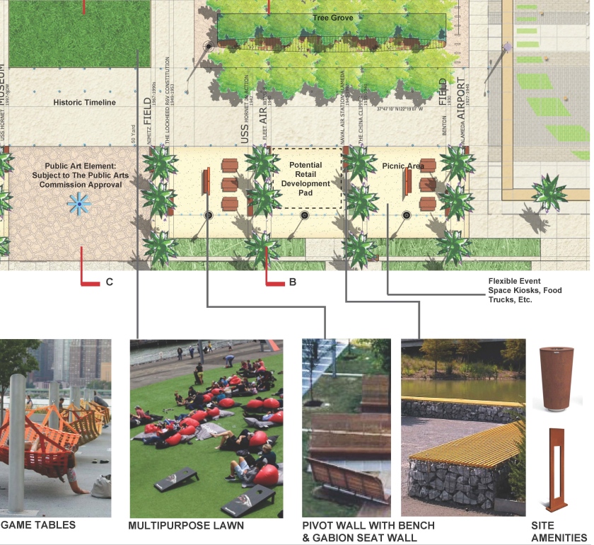
“The 2.63-acre Phase 1 Waterfront Park is designed to create three primary sub-areas (i.e., the Overlook, the Promenade & Terraces, and the Taxiway).”

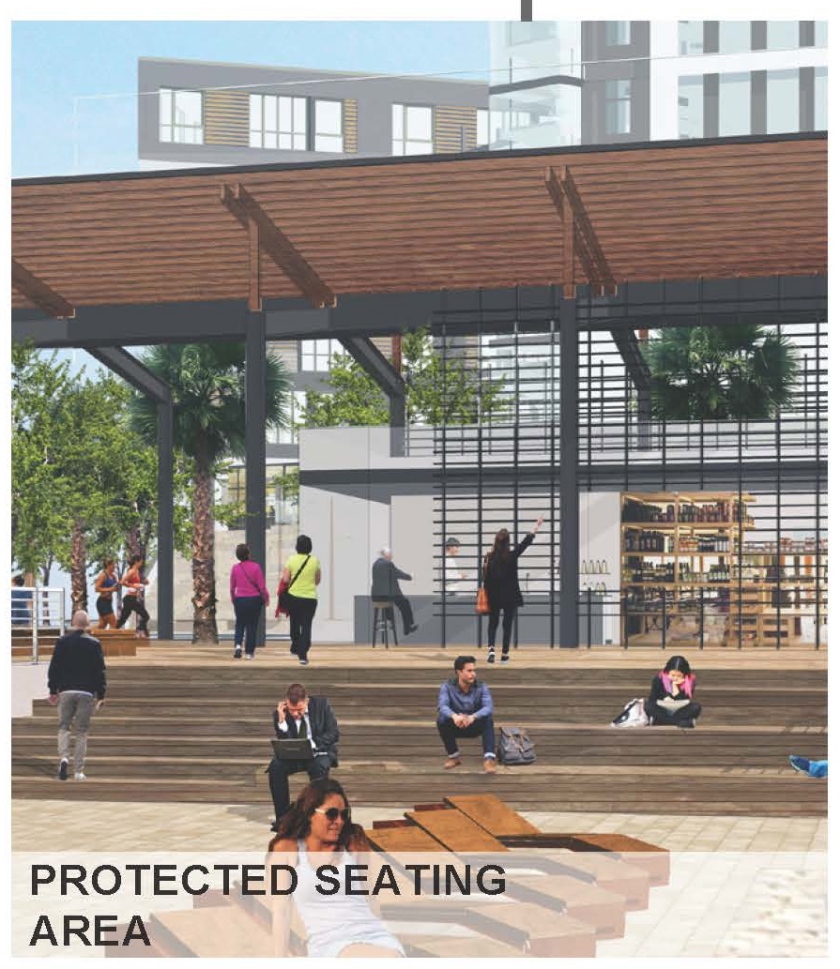
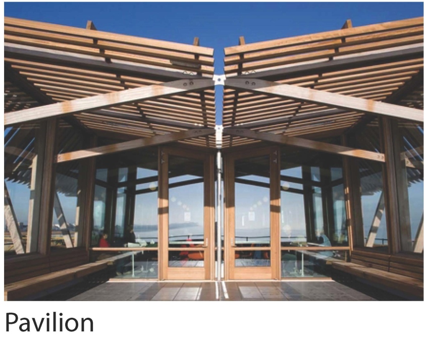
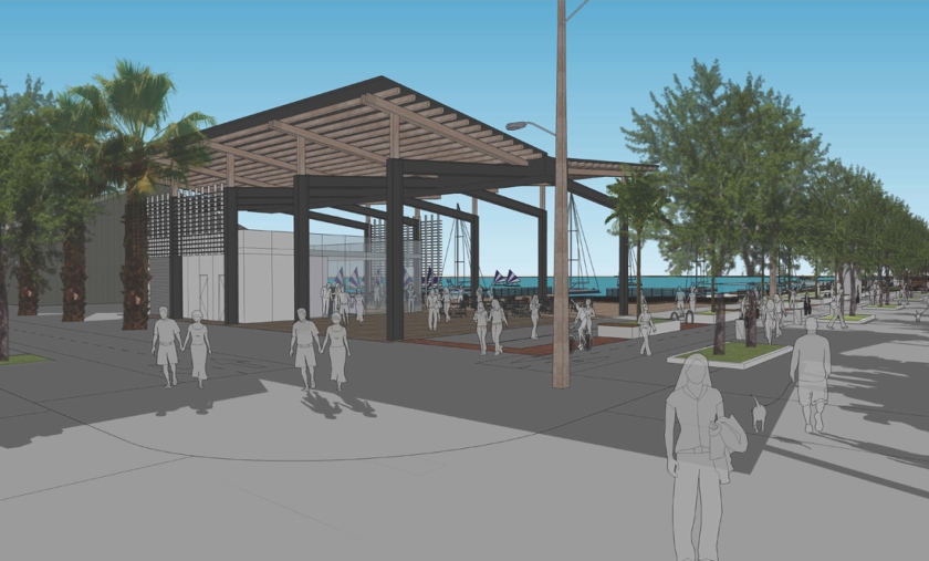
“The Overlook includes a pavilion for a café with outdoor seating and restrooms, as well as an elevated salvaged or reclaimed wood outdoor area for overlooking the promenade at the water’s edge, as well as portions of the promenade adjacent to the water. The Overlook also accommodates flexible event and programmable space.”

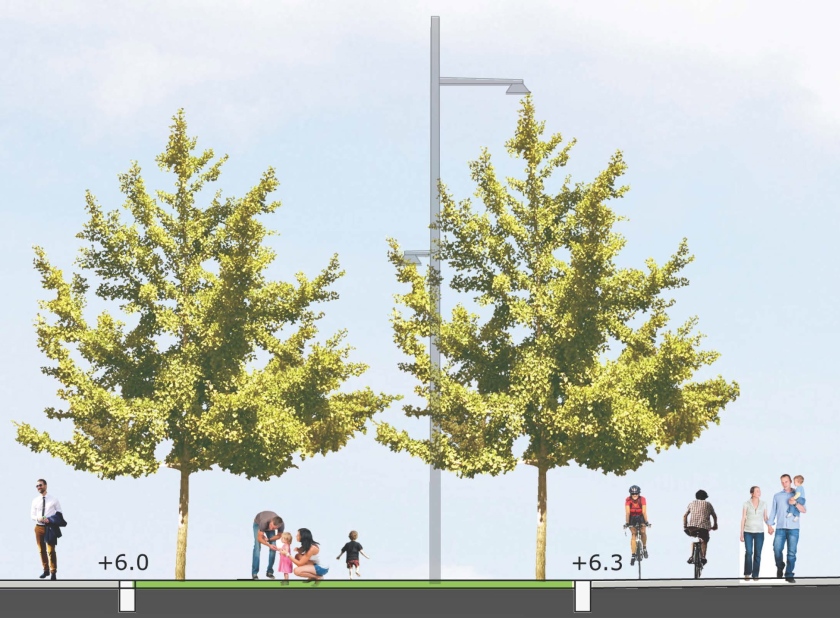
“The Promenade and Terraces consists of a series of terraces and promenade spaces leading down to the water’s edge that provide for a variety of more passive spaces for enjoying and experiencing the waterfront. Access to the waterfront promenade allows for universal design through slightly sloped walkways and seating elements that provide for a variety of all age groups and needs.”

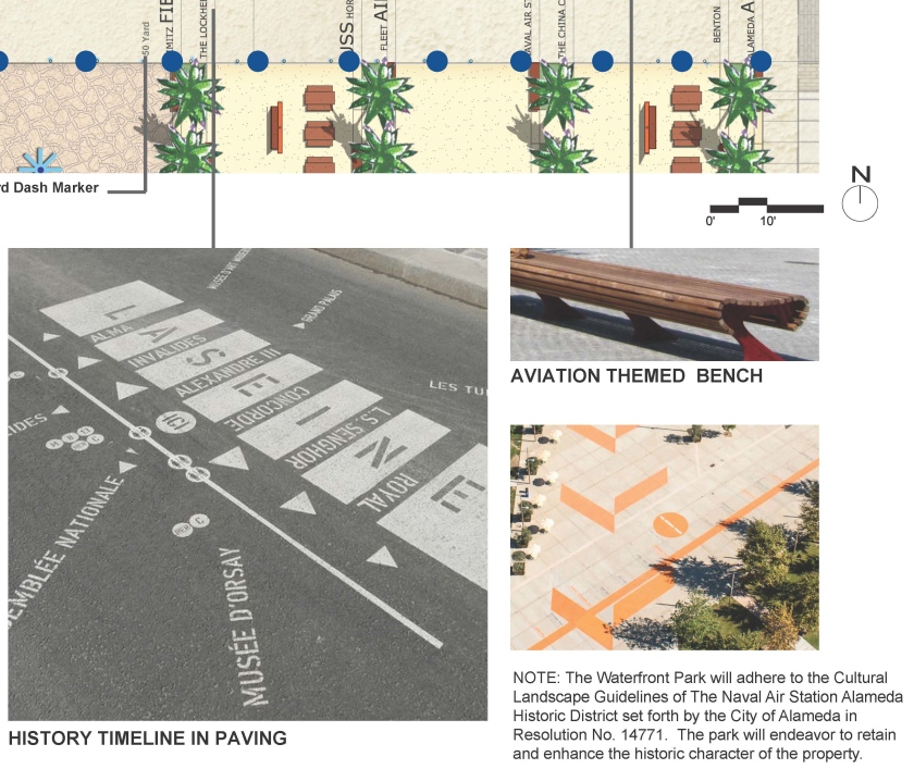
“The Taxiway area is intended to pay homage and respect to the historic elements of the former NAS Alameda by engraving a timeline along the major east west gathering area into the concrete to remind and educate the public about the history of the site and the Historic District, and by minimizing tree plantings and planted areas to preserve the ‘openness’ of the historic taxiways consistent with the Historic District guidelines. This area includes open and unobstructed areas planned for special events and food trucks and future retail buildings as conceived in the Site A Development Plan and a temporary multi-purpose lawn for active recreation uses until future phases of the Waterfront Park are constructed and this area is designed consistent with the areas to the north.”

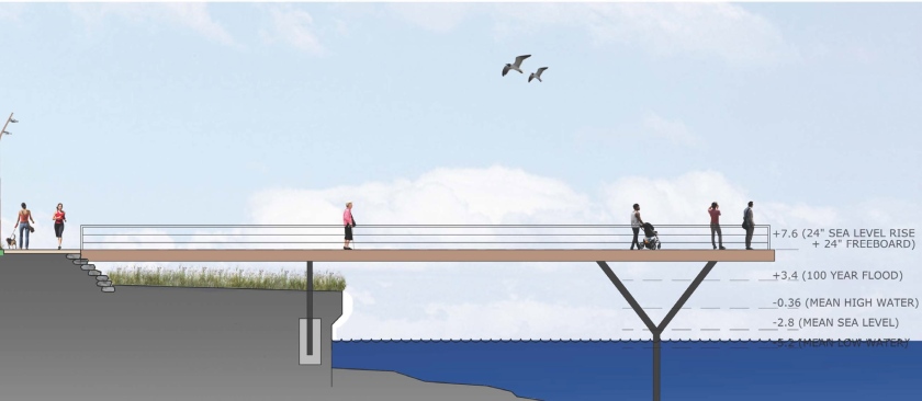
“Address Sea-Level Rise. With anticipated sea level rise, the existing taxiways will flood. Consistent with the approved MIP and San Francisco Bay Conservation and Development Commission (BCDC) policies, the Phase 1 Waterfront Park is designed to address 24-inches of sea level rise and additional sea level rise in future years beyond 24 inches through adaptive management strategies.”
“The Phase 1 Waterfront Park design maintains the “horizontality” of the space and minimizes the use of walls in order to respect the cultural landscape guidelines for the Historic District.
“Additionally, the sea level rise strategy is designed around a series of short terraces spread over a larger space to minimize the impression of changes in elevation. This approach also allows for the preservation of the existing bulkhead, which is a character defining feature of the Historic District. During storm events and “King Tides” (unusually high tides), the bulkhead and adjacent promenade will flood occasionally as the sea level rises over time, but major portions of the public park and Bay Trail will remain above the flooded areas behind the stepped terraces. As such, the design balances the competing needs to address sea-level rise, preserve the bulkhead, and maintain the horizontality of the site.”


It would be fantastic to see more native trees, like the coastal redwood included in the landscaping.
LikeLike
The development is going in the right direction- but I still feel that they need to consult with a better outdoor artistic design group. This is alameda, and this is the point we are talking about, facing SF, and on the water to boot!
The design, although it incorporates much of the old base history, will still feel too much like the old cold base. This should be treated as a jewel in the bay, with Tuscan influences or a more Mediterranean feel to it. Not like Area 51! Where are the pavers and beautiful stone work that incorporate so well with the ocean and greenery?! From what I am looking at- the developer has opted for the very basic setup as far as layout is concern and is trying use a few trees and cheap wooden pagodas to influence this directio, marked by history.
The decomposed granite along the water with the palms is a good start- mediocre to say the least- but more thought and outside assistance, needs to go into the design element of the aesthetics surrounding the water.
LikeLike
Some of us love the “…old cold base”. Because that’s what it is. Rather than disrespect its historical architecture and vital role in Alameda’s history by trying to tart it up with “Tuscan influences or a more Mediterranean feel”, why not make more effort to preserve its authenticity and integrate new structures with the existing architecture?
LikeLike
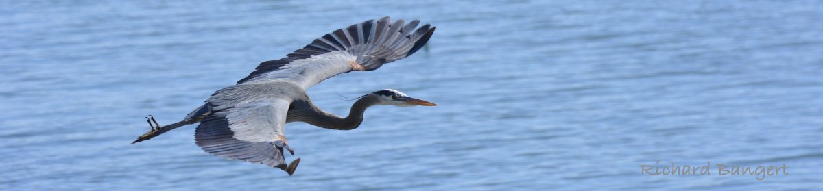
What I would like to see is a larger map showing the extent of the development. Hopefully somewhere on the point there would be a wildlife refuge. It’s nice they have photos of birds, because if we don’t have enough safe space for those birds to nest, that’s the only time you will see them, in photos.
LikeLike
Just another thought. All those green lawns will be brown in the first year. Climate change and reduced water use will see to that. But on a lighter note, the bathrooms aren’t in the first phase, so if you can’t hold it, you might as well water the lawns. 🙂
LikeLike